Hiking Distance: Easy walk from parking area; 2.2 miles for full hike
Cautions: High temperatures during summer; potential for falling rocks if climbers are above you
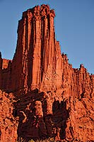 Fisher Towers is one of those places that many travelers stumble upon by accident on their way to or from Moab and say, “Wow…good thing we didn’t miss this!” If you’re headed west towards Moab on Utah SR-128, your first glimpse of these monolithic sandstone pinnacles is one of the most photographed scenes in southern Utah. Fisher Towers is one of those places that many travelers stumble upon by accident on their way to or from Moab and say, “Wow…good thing we didn’t miss this!” If you’re headed west towards Moab on Utah SR-128, your first glimpse of these monolithic sandstone pinnacles is one of the most photographed scenes in southern Utah.
After passing mile marker 25, a small pullout on the right side of the road treats you to an iconic view of the distant Fisher Towers framed by the La Sal Mountains and the Colorado River. From this vantage point, you can see the two largest of the towers: King Fisher and the 900-foot Titan, said to be the largest free-standing sandstone tower in the Western Hemisphere. But that glimpse is just a preview. Once you reach the base of Fisher Towers, you discover that Titan and King Fisher are the tall guardians watching over an entire labyrinth of eroded spires and pinnacles.
Fisher Towers, named after a miner who lived in the area in the 1800s, are the remnants of a floodplain that was deposited from the Uncompahgre highlands in western Colorado about 225 million years ago. Millions of years of erosion wore away the softer layers of sandstone, leaving the more resistant rock that makes up the towers.
The bottom and middle sections of the towers consist of the mudstones of the Cutler Formation, a geologic layer that formed in the arid climate of the Permian Period about 290 million years ago. The darker section at the top of the towers is the more resistant Moenkopi Formation, known for its ripple marks in many locations throughout the Colorado Plateau region.
The rocks in both these formations owe their bright red color to hematite—the mineral form of iron oxide that gives rust its color. One of the most unique things about the towers is their drapery-like appearance, which evolved as rain water percolated down the highly erodible sandstone and left ruts. 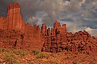
Erosional processes continue to chisel away at Fisher Towers even today. Proof of this came in July 2014 when one of the area’s best-known formations, called the Cobra, came toppling down after a heavy rainstorm. The 40-foot sandstone tower was capped by a rock that looked like the head of a snake and was a popular location for rock climbers. According to the Bureau of Land Management, a lightning strike and/or strong winds likely brought down the Cobra, leaving a pile of rubble where an iconic feature once stood.
Much of the rock at Fisher Towers is loose and crumbly, so this is the last place you might imagine that rock climbers would want to dig their bolts in and ascend 800-900 feet. But in 1962, three ambitious young men from Colorado became the first rock climbers to summit the Titan, which put Fisher Towers on the climbing map. It’s now considered to be one of the classic climbs in North America.
Fisher Towers has also been featured in a long list of films and commercials, including Nurse Betty and City Slickers II. In 2012 Citibank shot an ad here that featured two climbers summiting the precarious “Corkscrew” formation at the top of the Ancient Art Tower. The footage was so spectacular that Citibank received a slew of comments from viewers who thought it had been staged. But no, they didn’t airlift the climbers onto the rock—the climbing was real.
Suffice it to say you shouldn’t consider strapping on climbing gear unless you’re extremely experienced. But if you’re lucky enough to be here when climbers are in the midst of an ascent, it can be a fascinating scene to watch.
If you want to actually step inside the maze of Fisher Towers, you can take the 2.2-mile trail that leads around the base of the towers to a scenic viewpoint of the surrounding valley. The full hike takes about 3-4 hours (with a total elevation gain of 970 feet), and it’s the only way to get a close-up view of the Titan from its base. At the end of the trail, you’ll get panoramic views of Fisher Towers, Onion Creek, Castle Valley, and the Colorado River.
Getting There
From Moab: Drive north from Moab on Hwy 191 and turn right onto SR-128. After about 21 miles, a sign indicates the right-hand turn to Fisher Towers. The 2.2-mile gravel road leading to the parking area is normally passable to most vehicles.
|
 Located in Michigan’s Upper Peninsula, the Copper Harbor Mountain Bike Trails are designated as an International Mountain Bicycling Association (IMBA) Silver Level “Ride Center”, ranking them as one of the top trail destinations in the world.
Copper Harbor hosts some of the county’s most scenic terrain and challenging trails and has been added to a number of riders’ bucket lists. Mountainous by Midwestern standards, a series of rocky, undulating ridges and valleys are highlighted by historic locations, old growth forests, pristine inland lakes and streams, mountain top vistas and rugged Lake Superior’s shoreline. Singletrack winds over bedrock, cobbled rock, hard-packed surfaces, extensive bridges and boardwalks and a total lack of sand. Constant elevation changes provide a Western-like riding experience, with sustained vertical climbs and descents over a variety of purpose built cross-country, flow and gravity trails. And the local bike shop operates a shuttle service for the downhill enthusiasts.
The summer climate in Copper Harbor is ideal for riding, with average highs in the 70’s (think Moab in the spring). Stay cool this summer and make plans for your next mountain bike vacation! More info at www.copperharbor.org
And be sure to mention you read about it in the Moab Happenings
|