Hiking Distance: Varies
Difficulty: Easy to moderate
Cautions: High temperatures during summer; some scrambling and ladders
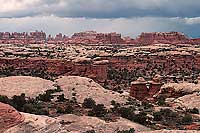 Canyonlands National Park encompasses three districts separated by the canyons of the Green and Colorado Rivers: Island in the Sky, the Needles, and the Maze. Each of these sections has its own unique character, but there’s something special—and otherworldly—about the Needles. Here, the brown waters of the mighty Colorado River join the more mellow waters of the Green River at the Confluence. Majestic red sandstone spires tower above narrow canyons and washes. And untold numbers of Indian ruins and rock art panels lay camouflaged in shaded alcoves. Ask someone who’s visited the Needles to describe what it’s like, and they usually say something along the lines of, it’s like being on another planet. Canyonlands National Park encompasses three districts separated by the canyons of the Green and Colorado Rivers: Island in the Sky, the Needles, and the Maze. Each of these sections has its own unique character, but there’s something special—and otherworldly—about the Needles. Here, the brown waters of the mighty Colorado River join the more mellow waters of the Green River at the Confluence. Majestic red sandstone spires tower above narrow canyons and washes. And untold numbers of Indian ruins and rock art panels lay camouflaged in shaded alcoves. Ask someone who’s visited the Needles to describe what it’s like, and they usually say something along the lines of, it’s like being on another planet.
In parks like Arches and Bryce Canyon, you’re usually in close proximity to lots of other people on the trails. But that isn’t the case in the Needles. In fact, the best way to communicate the remoteness of the Needles is to quote Tug Wilson (son of Bates Wilson, the first superintendent of Canyonlands National Park): No one is going to rescue you. The buzzards will show us where you are.
In other words, this is not the place to venture out on the trails haphazardly. The serpentine canyons in the Needles can be very confusing; one wrong turn and you can easily lose track of the trail. Take a map, a compass, and plenty of water, and make sure someone knows where you’re going.
Short Adventures in the Needles
Most hikes in the Needles are fairly long, requiring a full day or an overnight backpacking trip. If you have the time, these trails are some of the most spectacular in the American Southwest. But because many visitors to the Moab area only have time for a day trip, here are a few shorter trails that will give you a taste of the Needles and probably make you want to come back for a longer stay.
 Cave Spring Cave Spring
This short loop provides a glimpse into the Needles’ cowboy history, with an up-close look at a cowboy camp set in a rock alcove. Back in the late 1800s and early 1900s, cowboys began bringing livestock into the Needles. Because it was so remote and took so long to get there, they would often stay in the backcountry for weeks or months. Cave Spring was one of the most important camps in the area, and what you see there now is pretty close to what it looked like back then—complete with wooden tables, cooking utensils, and other tools. Just beyond the cowboy camp, you’ll pass through two alcoves where you can see handprints and pictographs, evidence that the area was used by Indians before the cowboys arrived. Continuing on the loop, you’ll soon ascend two ladders to the top of the slickrock plateau, where you’ll have nice views of the La Sal and Abajo mountains. The trail returns to the parking area.
Pothole Point
This short hike (.6 miles) takes you over a large stretch of sandstone filled with potholes—natural depressions in the sandstone that collect rainwater. Potholes are home to tiny plants and animals, such as fairy shrimp and tadpoles. These organisms have evolved to survive extended periods of dryness interrupted by short wet periods. During dry times, their microscopic eggs remain dormant in the mud; they then hatch and come to life after the rainstorms that typically occur in spring and summer. Resist the urge to stick your hands in the water, as oils, lotions, and sunscreen can make the water uninhabitable for the tiny life forms. Please don’t walk through dry potholes—your footsteps will crush the tiny, fragile eggs.
“Campground Trail”
This hike takes you on a short loop around Squaw Flat campground, providing superb distant views of the sandstone spires for which the Needles is named. There are several variations you can do from both Loop A and Loop B of the campground. It’s not a trail that’s included on the park’s trail guide, but if you ask nicely at the visitor center, you might be able to score a copy of the “unofficial” map that a visitor sketched of the “Campground Trail.” If you only have time for one short hike, this one gives you the best views.
Getting to the Needles
From Moab:
Head south on Hwy 191 for 40 miles. Turn right onto SR 211 and drive 34 miles to the Needles Visitor Center. Note: About 6 miles before you reach SR 211, you’ll see a signed turnoff to the Needles Overlook. Do not turn here. The Needles Overlook is a worthwhile stop if you have time (the overlook is 22 miles from Hwy 191), but the road will not get you to the Needles section of Canyonlands National Park.
|