Scenic Roads Happenings July 2010
Shafer Trail
Article and photos by Rob Cassingham
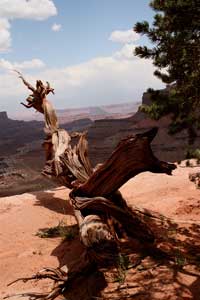 Mile 3.6 A dead pinon still stands above the Shafer Trail. Mile 3.6 A dead pinon still stands above the Shafer Trail. |
The Potash Road/Shafer Trail may be the most fantastically scenic route in the entire Moab region. Sheer cliffs tower above you, the Colorado River far below, a rugged warped and broken landscape, the possibility of spotting some Desert Bighorn Sheep and many more wonders make this trip unforgettable. The route is a moderately easy drive, appropriate for even light-duty SUVs such as Subaru station wagons and Toyota RAV-4s. There are some tight switchbacks to negotiate, so this road is not appropriate for motorhomes or vehicles towing trailers, and standard highway vehicles are not advised. In addition, there are several sheer drop-offs that require the driver to pay close attention to the road. Visitors terribly afraid of heights may not enjoy portions of this trip.
To begin your trip, start at the intersection of Main and Center streets and drive north on Main Street/US Highway 191 4.0 miles, and then turn left on Utah Highway 279 (also known as the Potash Road). Reset your trip meter (if you wish to have more detail of the Potash Road, the route was detailed in the January 2010 issue of Moab Happenings. You may find the article online at http://www.moabhappenings.com/Archives/ScenicRoads1001PotashRoad.htm).
You will now be traveling the Potash Road 15.3 miles to the start of the Shafer Trail road log. Some brief highlights of the Potash Road:
Mile 4.2 You are entering “Wall Street”. The sheer cliffs on the right are frequently scaled by rock climbers. The speed limit over the next mile is 35 mph. Drive carefully!
Mile 5.0 and 5.1 Petroglyphs
Mile 5.9 Dinosaur track
Mile 9.9 Trailhead to Corona Arch. This hike is 3 miles and is moderately difficult. Well worth the effort-bring plenty of water!
Mile 13.4 Long Canyon/Jughandle Arch
Mile 15.3 Potash Plant. Utah 279 ends, and an unimproved road continues past this point. Reset your trip meter.
 Mile 4.3 “Superhuman Rock” Mile 4.3 “Superhuman Rock” |
Mile 0 Potash Plant. The buildings to the right are shipment facilities for the nearby potash mine. This mine has been extracting potash (commonly used in fertilizer) and salt from the subsurface Paradox salt deposits for nearly 50 years. Originally, the salt and potash was extracted conventionally from mine shafts. In 1963, an explosion in the 2,700 foot/823 meter mine (at the time, the deepest mine in the country) killed 18 miners. Since then, potash and salt have been extracted by pumping water into the old mine shafts, then pumping the water to several vast evaporation ponds. After the water evaporates, it leaves behind the salt and potash, which is then scraped up and prepared for market. You will pass the ponds in 4.5 miles.
Mile 1.4 A short spur road to the left leads to the Potash boat ramp. There is a pit toilet near the ramp. Note that this is the last rest room for the next 12 miles (and two or three hours).
Just beyond the ramp, the road becomes dirt and begins to climb above the river.
Mile 1.7 A small road (‘two track’) heads to the right. If you follow this road for 100-200 yards, it peters out on a hard gray bed of limestone. This limestone deposit was once the floor of a shallow tropical sea 300 million years ago. If you search along the right edge of this limestone, you will see fossilized horn and brain corals, crinoid body stems (similar to modern sea lilies), and rarely found sea shells. Please do not attempt to remove the fossils-the limestone is VERY dense.
Mile 3.6 Stop sign. This intersection is at the crossroads with the main road used by the potash mine. Mine traffic has the right of way, so proceed carefully through the intersection.
Mile 3.9 The road climbs steeply upward into a mass of dark reddish deposits of Organ Rock shale.
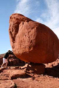
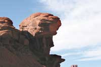 Mile 4.3 “Head of Sinbad” Mile 4.3 “Head of Sinbad” |
Mile 4.3 Above the road to the left is a rock outcropping that resembles the head of Sinbad. To the right side of the road is a large rock precariously balanced, with light visible below the rock. “Superhuman Rock” makes for a good photo, as people can pose as though they were going to shove the rock over. Please note that there are some sheer cliff edges nearby, so watch young children carefully.
Mile 4.5 The first of the large evaporation ponds mentioned at the start of the road log. A blue dye is added to the water to speed up the process of evaporation.
Mile 6.7 You have just crossed a cattle guard and entered BLM lands.
Mile 9.2 The road begins to climb steeply and the road surface is often bare limestone.
Mile 10.0 Thelma & Louise Point |
Mile 10.0 The top of the steep grade and a cattle guard. There is a short spur to the left the leads to a great scenic overlook. This overlook was once known as ‘Fossil Point’, but is now known as ‘Thelma and Louise Point’. If you have seen the movie ‘Thelma and Louise’, you may remember the climax of the film when the women drive their car off of the cliff. This is the location where that stunt appeared.
If you look at the clifftops to the right of the road, you may notice the viewing platform at Dead Horse Point State Park over 1,000 feet above you.
Mile 11.0 The road travels along a narrow bench high above the river. Use caution! There is a blind curve at this point. If anybody in your party finds this drop-off too frightening, know that there are more sheer drop-offs farther down this route.
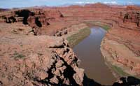
Mile 11.6 Nice viewpoint above the ‘gooseneck’ of the Colorado River.
Mile 12.6 You have just entered Canyonlands National Park. The park is a fee area, and you will need to pay your park admission after this route reaches the pavement inside Canyonlands NP.
Mile 13.3 Rest room.
Mile 14.4 Intersection. The road to the left leads to the White Rim Trail; the road to the right leads to the switchbacks of the Shafer Trail. Reset your tripmeter and turn right.
Mile 0 Start of the Shafer Trail. The Shafer Trail was originally just a narrow path that wildlife (primarily bighorn sheep) would use to travel between the mesa top and the area now known as the White Rim Trail. Later, when cattle ranching was king, the trail was widened and improved in order to drive herds of cattle to Moab. When uranium frenzy gripped the region in the 1950s, the Shafer Trail was further widened and improved to allow the regular travel of 2-ton and 5-ton dump trucks laboring under full loads of uranium ore from the many mines that once dotted the area. Without the uranium industry, this road likely would never have been anything more than a livestock or a hiking trail.
Mile 0.7 The road starts uphill. Over the next two miles, the road climbs up an extremely steep grade, gaining over 1,000 feet in elevation. There are four sharp switchbacks to negotiate. There is an unwritten rule that downhill traffic should yield to uphill traffic, but not every traveler knows this rule. Therefore, try to spot oncoming traffic early and be prepared to use a wide spot on the road to pull over in order to let traffic by.
Mile 2.6 After a blind curve, the road climbs much more gradually and travels along a narrow bench far above the desert floor. The road is much easier-the ‘worst’ is behind you.
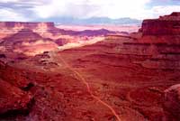 Mile 3.6 The setting sun sets the desert ablaze with reddish hues. Mile 3.6 The setting sun sets the desert ablaze with reddish hues. |
Mile 3.6 There is a broad sandstone ledge on your right that affords a spectacular view. It is well worth stopping here and taking some photographs.
Mile 5.3 You have reached the paved road inside Canyonlands NP-Island in the Sky District. There is a self-pay station here, or you may turn right at this intersection, drive a short distance to the park entrance booths, and pay your admission fee there.
Turning left at this intersection and driving one mile will bring you to the park’s visitor center. There you will find maps, books, water, restrooms and more. If you intend on viewing the rest of the Island in the Sky, the visitor center is where you want to visit for more information.
Once you are ready to return to Moab, please follow the main park road east past the visitor center. In approximately 4.5 miles, you will reach the intersection of Utah Highway 313. If you wish, you may turn right and follow the road another 4 miles to Dead Horse Point State Park. If you choose not to visit the state park, continue east on highway 313 for another 14.5 miles to the intersection of US Highway 191, then drive south on 191 back to Moab.
Moab Happenings hopes that you enjoyed this magnificent drive, and we hope you will return often to enjoy ALL that Moab has to offer! |