Hiking Happenings
October 2006
Getting
Back to Amasa
by Rory Tyler
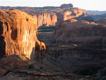
Kane Creek/Colorado
Confluence. Amasa Domes on the left
|
First things first. For fall color,
go to the mountains in early October. Later, try Negro
Bill Canyon, Courthouse Wash, Mill Creek, or the Kane Creek/Colorado
confluence, which takes us to the topic at hand, Amasa
Back. (I’ve heard it pronounced a MAH sah, a MAS
a, AM a see, AM a sah, and so on. Take your pick.)
The proximity of bicyclists and four-wheel enthusiasts
might lead a hiker to underestimate the attractions of
Amasa Back. This is an accommodating place to walk away
the day, offering a full range of hiking opportunities,
from walks-in-the-park to treks-in-the-wilderness.
Amasa Back is a cliff-sided ridgeline that forms a miles-long
gooseneck hundreds of feet above the Colorado River. Its
vistas are among the most diverse anywhere in the canyon
country. Kane Creek borders the east end of the ridge.
All hiking access begins here. Take Main Street (Hwy 191)
south to the 500 West/Kane Creek turnoff. Stay next the
cliff, turning left where Kane Creek Boulevard and 500
West split. The Kane Creek/Colorado confluence is about
three miles up the road, where it changes from pavement
to gravel. At the parking lot, face the river. Jackson’s
Trail begins in the lower left part of the lot.
In the first couple hundred yards, Jackson’s Trail
drops off a ledge, through a tunnel of dense tamarisk brush,
and across Kane Creek (usually a wet crossing). Then it’s
a straightforward climb along a ramp of Kayenta sandstone
that ascends above the river until you reach the top, in
about forty-five minutes. I like this route for casual
hiking. The footing is excellent and it’s not as
long or messy as the main route. Nor are there many bicycles
and you don’t have to walk on the slippery crushed
rock left behind by four-wheelers. At the top of the trail
you’ll come to some power lines. One option here
is to follows the power lines to the left, cross the four-wheel
drive road, and walk across the narrowest part of Amasa
Back where you’ll get a radically different set of
views than the ones that have been astounding you so far.
This is also the trailhead for Jackson’s Hole, which
is another matter entirely. Or, you can make a loop on
the main trail, back to Kane Creek Road and your conveyance.
A more adventurous option is to go under the lines and
forge north, the direction you’ve been going, for
some off-trail exploring. It’s an interesting area,
not too intimidating, and you can turn left and climb out
to the main trail at any time.
The main Amasa Back trail is about a half-mile further
up Kane Creek Road and is clearly marked. From the trailhead
you can see a huge, eye-shaped alcove across the canyon.
There’s some terrific rock art about twenty yards
to the left of the alcove. With binoculars, you can see
it well from the start of the trail. To get there, cross
Kane Creek, take the first side-canyon up to the wall,
then work your way back along the ledge toward the alcove.
It takes about an hour to reach the crest of the ridge
on the main trail and, as noted, you may be sharing it
with bicycles, motorcycles, and jeeps. At the crest, go
cross-country a quarter mile to your left for the views
of Lockhart Basin, Jackson’s Hole, Deadhorse Point,
and the Potash Mine.
About half way up, the main trail rounds a point and heads
toward three distinct towers of sandstone. An interesting
hiking option from here is to leave the main trail, climb
to the saddle on the right, then cross-country out to the
domes above the Cane Creek/Colorado confluence. This is
spectacular stuff, but it’s not for everybody. It
requires some route-finding ability, desert experience,
and physical confidence.
From the point, another option is to round the head of
the canyon on your left and work your way towards a large
Navajo sandstone remnant I refer to as The Whale. This
route takes you to the east end of Amasa Back and the most
spectacular views in the area. Here, Amasa Back is notable
for the large, gently sloping, easily traversed, slabs
and ledges of gray Kayenta sandstone and its exotic crypto
gardens. Above and beyond The Whale you’ll see a
large outcrop of canyon-cut Wingate sandstone comprising
the crest of the ridge. Intrepid, determined, skilled,
and/or foolish hikers will find this an especially inviting
place.
One last thing. There are some archeological remains scattered
here and there on Amasa Back. Anyone who defaces a rock
art panel or steals an artifact is, by definition, Evil
and will spend Eternity manning the drive-thru window at
a fast food joint in Hell taking diabolically distorted
short-orders from ravenous hordes of demented demonry.
Don’t say you weren’t warned!
Rory Tyler is available
for cowboy poetry/campfire song gatherings which include
lore, science, history and lies of the Moab area. (Suitable
for all age groups). Rates are negotiable. Give Rory
a call at 435-260-8496.
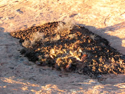
Cryptobiotic soil
garden
|
|