HIKING HAPPENINGS
March 2008
The Moab Rim
- Chasing the Winter Sun
by Marcia Hafner
 After
a long, cold, snowy winter, I am so ready for spring. For
too long most trails have been bogged down with snow, ice
and mush, and many hikers have voiced one big question: Where
can they go for a snow-free walk? The trail that has worked
well for me is the Moab Rim. Angled just right to catch most
of the solar rays, its sun-soaked uplifted ledges of Kayenta
sandstone absorb the heat. The radiant energy quickly melts
that mantle of snow. Except for one small shady spot on the
upper trail, it’s a dry walk on slickrock all the way
to the rim. The short drive from town gives me the option
of a quick hike with plenty of time to spare for other activities.
With a close-by, dry trail, I can’t come up with any
silly excuses for not getting out for some rigorous wintertime
exercise. After
a long, cold, snowy winter, I am so ready for spring. For
too long most trails have been bogged down with snow, ice
and mush, and many hikers have voiced one big question: Where
can they go for a snow-free walk? The trail that has worked
well for me is the Moab Rim. Angled just right to catch most
of the solar rays, its sun-soaked uplifted ledges of Kayenta
sandstone absorb the heat. The radiant energy quickly melts
that mantle of snow. Except for one small shady spot on the
upper trail, it’s a dry walk on slickrock all the way
to the rim. The short drive from town gives me the option
of a quick hike with plenty of time to spare for other activities.
With a close-by, dry trail, I can’t come up with any
silly excuses for not getting out for some rigorous wintertime
exercise.
To get to the Moab Rim trailhead, go south on Main Street
and turn right at McDonald’s on to Kane Creek Blvd.
At the Yield sign (1.5 miles from McDonald’s) go straight
(not right) and stay on Kane Creek Blvd. The trailhead is
3.5 miles from the turnoff at McDonald’s. When you’ve
crossed the cattle guard you’re almost there, so be
on the lookout for the parking lot with a primitive restroom
on the left hand side.
This steep multi-use trail is rated as a moderate to difficult
hike. Locally known as the “Moab Stairmaster,” it
climbs at a heart-thumping rate of 1,000 feet in approximately
one mile. To stay on the trail, follow the painted white
blocks and black tire marks. Near the top the grade is an
unrelenting 25%! It is 1.4 miles to the first overlook and
3.0 miles to the Hidden Valley Trail connection. If you want
to go over the Hidden Valley Pass and down to that trailhead,
plan on a six-mile one-way walk.
 Sheer
cliffs of Navajo sandstone tower above the trail where they
abut against the northeastern boundaries of Behind The Rocks
Wilderness Study Area. This area immediately off the trail
has been closed to off-highway vehicles since 1985 to protect
its outstanding scenic values. All vehicular traffic including
mountain bikes is required to stay on the trail. Sheer
cliffs of Navajo sandstone tower above the trail where they
abut against the northeastern boundaries of Behind The Rocks
Wilderness Study Area. This area immediately off the trail
has been closed to off-highway vehicles since 1985 to protect
its outstanding scenic values. All vehicular traffic including
mountain bikes is required to stay on the trail.
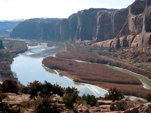
Upward momentum provides increasingly far-stretching, elevated
views of the Colorado River. At the beginning of the trail,
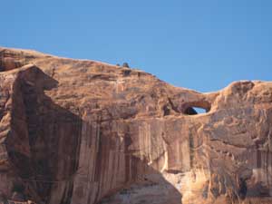
an arch can be seen on the other side of the river. To find
it, let your eyes scroll up on the cliff face almost to the
top of the rim. From this angle the arch looks unapproachable,
but it is a short comfortable walk from the Poison Spider
Trail. As you gain elevation The Portal becomes an impressive
and towering image above the northeast side of the river.
Next to The Portal a huge indentation in the skyline rimrock
that I refer to as “The Notch” shows up in stark
relief. A long glance farther downriver brings into view
the well-known “Wall Street,” which is frequently
used by rock climbers.
Three-fourths of the way to the rim, there’s a short
passage through the Moab Rim Preserve. Purchased by The Nature
Conservancy in late 2005, it is managed in cooperation with
the Bureau Of Land Management (BLM.) The Nature Conservancy
removed the privately run passenger tram operation and closed
the adjoining side roads to motorized vehicles to avoid damage
to the vegetation. The main trail will remain open to the
public as long as everyone respects the land by staying on
the established road.
Sandstone, lack of soil, and aridity force the vegetation
to take a low profile. Stunted, gnarled junipers are few
and far between as each one struggles for its existence in
meager pockets of dirt. In the more fertile areas at the
top where the trail levels out, blackbrush and Mormon tea
do grow and thrive.
Just past an informational sign the main trail goes right
and, for jeeps, dead-ends in a mile. A short spur to the
left ends at a viewpoint. Here’s what you miss if you
pass it by – the Bookcliffs, the wetlands of the
Matheson Preserve, short sections of the river, Arches National
Park, the La Sal Mountains, domes that flank the beginning
of Behind The Rocks, Sand Flats Recreation Area and a deep
gash that belongs to Mill Creek Canyon. All of Moab can be
seen, and most recognizable are Holiday Inn, Desert Bistro,
Pete Byrd’s farm, and the Sunset Grill with the painted
white “Big G” behind it.
The main route continues south through a slickrocked area
located between two large domes of Navajo sandstone. It goes
on along a wash bottom and up a large sand hill where there
are several short spurs to viewpoints of Spanish Valley.
After another portion of foot-dragging sand, it hooks up
with the Hidden Valley Trail.
If you want to enjoy the quietude of a walk on the Moab Rim
Trail, do it now before Jeep Safari starts. Since this is
a multi-use trail, when the weather gets nice especially
on the weekends, you’ll be sharing it with a plentitude
of people. If you’ve never done it before it can be
of interest to watch a skilled driver maneuver his machine
over the ledge obstacles - including the most difficult of
them all, “The Devil’s Crack” and “The
Z Turn.” Be prepared for a lot of drama. Rollovers
do happen, so keep your distance!
It’s no secret to local hikers that the Moab Rim is
at its best in the winter when an afternoon walk on this
trail is a peaceful intermission in their day. In the chilly,
still air I can easily hear the soothing chatter of the chickadee,
the raven and the canyon wren. That’s when I’m
on the Moab Rim chasing the winter sun.
|
Biological
Soil Crust (aka)
Cryptos (krip’ tose):
The surface of
Moab’s desert is held together by a thin
skin of living organisms known as cryptobiotic
soil or cryptos. It has a lumpy black appearance,
is very fragile, and takes decades to heal when
it has been damaged. This soil is a critical part
of the survival of the desert. The cryptobiotic
organisms help to stabilize the soil, hold moisture,
and provide protection for germination of the seeds
of other plants. Without it the dry areas of the
west would be much different. Although some disturbance
is normal and helps the soil to capture moisture,
excessive disturbance by hooves, bicycle tires
and hiking boots has been shown to destroy the
cryptobiotic organisms and their contribution to
the soil. When you walk around Moab avoid crushing
the cryptos. Stay on trails, walk in washes, hop
from stone to stone. Whatever it takes, don’t
crunch the cryptos unless you absolutely have to! |
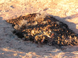
Cryptobiotic soil garden
|
|
|