HIKING HAPPENINGS
May 2008
Klondike Bluffs – An Off Beat Haven in Arches National Park
by Marcia Hafner
 The out-of-place name had grabbed my attention for a long time; it conjured up images of the Far North -- not a desert landscape inside the northwest border of Arches National Park. It is said that Klondike Bluffs was named for the moody extremes of cold temperatures experienced in this area. I finally decided to find out what this mysterious Klondike Bluffs was all about, even if it meant a fifteen-mile detour off pavement, traveling solo on a remote dirt road. The out-of-place name had grabbed my attention for a long time; it conjured up images of the Far North -- not a desert landscape inside the northwest border of Arches National Park. It is said that Klondike Bluffs was named for the moody extremes of cold temperatures experienced in this area. I finally decided to find out what this mysterious Klondike Bluffs was all about, even if it meant a fifteen-mile detour off pavement, traveling solo on a remote dirt road.
The entrance to Arches National Park is just five miles north of Moab on Highway 191. The park is open year round and is least crowded in the winter. A seven-day pass costs $10.00 per vehicle or $5.00 for bicyclists, walk-ins and motorcycles, while an annual pass for Arches, Canyonlands, Hovenweep and Natural Bridges can also be purchased for $25.00. Year round camping is available, but only in the Devils Garden Campground, which has centrally located flush toilets, potable water, picnic tables and grills.
The eerie, other-worldly formations of Arches National Park began their birth process three hundred million years ago - way back when a large sea invaded the Colorado Plateau. As time went on the sea evaporated, depositing huge layers of salt thousands of feet thick. Residue from recurring floods, incessant winds and the rhythmic cycle of ingoing-outgoing oceans persistently covered the original bed of salt and the left- over debris was compressed into rock, possibly as thick as one mile. The tremendous pressure made the salt bed unstable. It consequently shifted, buckled, liquefied and changed position, thrusting the layers of rock upward into domes while other large sections fell into cavities. Surface erosion stripped off the layers around the young rocks. Water seeped into the cracks and froze, and the expanding pressure broke off bits and pieces leaving behind freestanding fins. Then wind and water attacked until the cementing material gave way and chunks of Entrada Sandstone fell out leaving behind the famous arch structure that gave the park its name.
There are over 2,000 arches in Arches National Park, but I have come here to see one very special arch in Klondike Bluffs. To get to the Klondike Bluffs trailhead I drive 16.4 miles from the visitor center and turn left on to the Salt Valley Road. There is no sign for the Salt Valley Road or Klondike Bluffs. You just have to know when to turn. The one and only sign warns travelers that the road is impassable when wet. There is a gate, which may be temporarily closed during inclement weather.
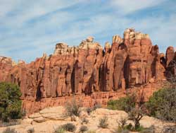
Skyline Arch, east of the main road, can be clearly seen from various spots along the Salt Valley Road. This narrow arch doubled in size in 1940 when a large chunk fell out from its window. At various points the whitish cap rock layered on top of the red Entrada sandstone of the Klondike Bluffs formation is also easy to pick out.
It is 7.2 miles on the Salt Valley Road to the one-mile marker sign for the trailhead. I make sure to take the second left-hand turn, not the first, which is a clearly marked four-wheel drive road. The last mile is a rough, washboardy ride. At the small trailhead, which has a pit toilet, I take care to park out of the path of others before gratefully getting out to unkink my torqued body. While stretching, I read the available information.
 Klondike Bluffs spurred the original inspiration for special protection of the region. Hungarian-born prospector Alexander Ringhoffer became the prime mover in establishing Arches as a national monument after exploring Klondike Bluffs in 1922, and his name is inscribed under Tower Arch. Ringhoffer invited officials from the Denver and Rio Grande Western Railroad to check out the area in hopes of inciting an interest in tourism. One of those railroad men, Frank Wadleigh wrote an encouraging letter to Stephen Mather, the first director of the National Park Service, convincing Mather to push for national monument status. By executive order, it received that designation in 1929 and became a national park in 1971. Klondike Bluffs spurred the original inspiration for special protection of the region. Hungarian-born prospector Alexander Ringhoffer became the prime mover in establishing Arches as a national monument after exploring Klondike Bluffs in 1922, and his name is inscribed under Tower Arch. Ringhoffer invited officials from the Denver and Rio Grande Western Railroad to check out the area in hopes of inciting an interest in tourism. One of those railroad men, Frank Wadleigh wrote an encouraging letter to Stephen Mather, the first director of the National Park Service, convincing Mather to push for national monument status. By executive order, it received that designation in 1929 and became a national park in 1971.
The moderately strenuous, well-marked Tower Arch Trail is 1.7 miles one-way. The first short section climbs steeply up a staircase of rock. On the slickrock I pay close attention to the well-placed piles of rock, called cairns, to guide me along the trail. Gaining elevation I experience increasingly broad views of Salt Valley and the Bookcliffs on the northern horizon.
When the trail flattens out to minor ups and downs, I feel encased by the odd-shaped stone-pillared landforms that surround me. The greenness of pinyons, junipers, cliffrose and Mormon tea contrast strongly against a reddish backdrop. To my right I’m looking at huge flattened rock structures that are stacked up like a deck of cards. I get peek-a-boo views of the La Sals Mountains as I wander between massive slabs of stone.
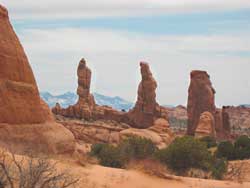
Over the first hump, I feel like I have just crossed the divide between the east and the west side; for now I can see The Abajo Mountains, traffic whizzing along on Highway 191, the Moab Airport and all the mesas and plateaus going on beyond to the western edge. After the next little hiccup in the trail, I am on a steady downhill roll with the three separate pillars of the Marching Men to my left standing guard. Crossing a wash I begin the final thrus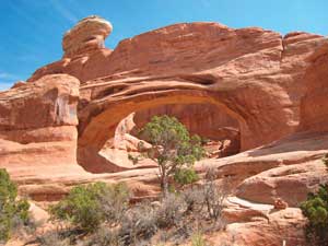 t of hard work up a sandy, uphill slug. The reward for all this effort is reaching Tower Arch. Nestled within a fractured area of rocks and named for the large rock buttress above the arch that looks like a tower, it stands 101 feet wide, 45 feet high. t of hard work up a sandy, uphill slug. The reward for all this effort is reaching Tower Arch. Nestled within a fractured area of rocks and named for the large rock buttress above the arch that looks like a tower, it stands 101 feet wide, 45 feet high.
Sitting under the arch, I take a long lunch break as I peer through a windowed, clear-blue sky. All is silent except for a pair of softly spoken white-breasted nuthatches communicating with each other as they search over crevices in the arch for insects, and the piercing voices of white-throated swifts making their theatrical aerial dives above the arch.
I kick back in contentment. Driving in on a rough road has been a small price to pay for this unique and peaceful off the beaten path place.
|
Biological Soil Crust (aka)
Cryptos (krip’ tose):
The surface of
Moab’s desert is held
together by a thin skin of living organisms known as cryptobiotic
soil or cryptos. It has a lumpy black appearance, is very
fragile, and takes decades to heal when it has been damaged.
This soil is a critical part of the survival of the desert.
The cryptobiotic organisms help to stabilize the soil, hold
moisture, and provide protection for germination of the seeds
of other plants. Without it the dry areas of the west would
be much different. Although some disturbance is normal and
helps the soil to capture moisture, excessive disturbance
by hooves, bicycle tires and hiking boots has been shown
to destroy the cryptobiotic organisms and their contribution
to the soil. When you walk around Moab avoid crushing the
cryptos. Stay on trails, walk in washes, hop from stone to
stone. Whatever it takes, don’t crunch the cryptos
unless you absolutely have to! |
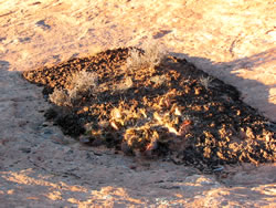
Cryptobiotic soil garden
|
|
|