HIKING HAPPENINGS April 2010
Mesa Arch – Waiting For Spring
by Marcy Hafner
 On my last outing in late February to the Island In The Sky district of Canyonlands National Park, I gazed out at a serene Siberian scene of white that stretched from horizon to horizon. The huge amount of snow that remained on the ground caught me by surprise, and with it came a sinking feeling that I wouldn’t be hiking here any time soon. On my last outing in late February to the Island In The Sky district of Canyonlands National Park, I gazed out at a serene Siberian scene of white that stretched from horizon to horizon. The huge amount of snow that remained on the ground caught me by surprise, and with it came a sinking feeling that I wouldn’t be hiking here any time soon.
This area lies within the rain shadow of the western mountains where, as a general rule, snowfall is light with an annual accumulation of 22.9 inches. The most snowfall recorded in one year was 47.4 inches in 1975 and the highest amount in one month was 27 inches in January 1978. Curious about this year’s snow pack, I called the National Park Service; during that conversation it was revealed to me that Island In The Sky has received more than three feet of snow this winter.
I asked about trail conditions at the visitor center and the park ranger informed me that he’d been using snowshoes on the Lathrop Trail. Snowshoes in the desert?! That’s when I realized it was going to be a long wait for spring when normal hiking activities could be resumed.
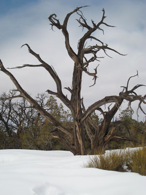
The big exception was the trail to Mesa Arch - a popular, well-used half-mile loop that had been packed down into a do-able, though somewhat slippery walk. I, however, quickly discovered that if I took a detour off the beaten path, I floundered in knee deep, heavy wet snow. Under normal conditions, with an elevation gain of just 100 feet, this is an extremely easy trail of sand with short sections of slickrock that leads to one of the most scenic and accessible arches on the Island In The Sky mesa.
To get to Mesa Arch, drive ten miles north out of Moab on Highway 191 and turn left on Highway 313. Then proceed another 25 miles to the park’s entrance station. The Mesa Arch trailhead is about five miles beyond the visitor center.
Situated within the geologic region called the Colorado Plateau, the Canyonlands National Park system encompasses 527 square miles of canyons, mesas, buttes, fins, arches and spires. It is segmented into three distinct areas – Island In The Sky (north), The Needles (south) and The Maze (west). Two major rivers, the Colorado and the Green cut through the heart of the park, carving out 2,000-foot canyons, which act as major barriers between the three districts. Horseshoe Canyon - a detached segment of the park -contains some of the most significant rock art in North America. Island In The Sky and The Needles are easily accessible with any vehicle, but to visit The Maze, a high clearance, four-wheel drive is essential. There are no roads that directly link the different sections of the park, which means traveling that distance between them requires two to six hours by car making it impractical to visit more than one area in a single trip.
Before it was awarded park status, few except Native Americans, cowboys, river explorers and uranium prospectors entered this rugged and remote corner of southeast Utah. Even today the majority of the park is a wild untamed territory where coyote, deer, kit fox and desert bighorn sheep have enough undisturbed space to freely roam. Only a remnant of ancestral desert bighorn sheep remain in this country and the park habitat is crucial to their survival.
In the late 1950’s and early 1960’s, Bates Wilson, superintendent of nearby Arches National Monument, led groups of scientists and government officials into the canyonlands. In the evenings around the campfire the talk would turn to the idea of designating this area as a national park, and that happened in 1964. United States Senator Frank E. Moss, who represented Utah, introduced park legislation saying “I will never lose sight of the fact that the most important thing for Utah and the United States is to set aside (and) preserve this beautiful area as a great national park in the tradition of Yellowstone, Grand Canyon, and Yosemite.”
As the name suggests, Island In The Sky rests on a high wide plateau surrounded like a floating island by a far-reaching landscape below. Filled with oddly shaped rock formations, it has commanding, almost overwhelming views in all directions, across many miles of spectacular, uninhabited land.
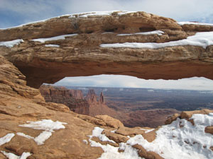 The smooth rounded rock along the trail to Mesa Arch is composed of Navajo Sandstone, which is actually petrified sand dunes. Oceans, lakes, streams, tidal flats, wind and water deposited these sand dunes; over millions of years, distinctive layers of sediment were left behind. As the sands drifted with the whims of the wind, they etched a series of mystifying diagonal lines into the rock, known as cross-bedding, that can easily be seen in the slickrock along the trail. The smooth rounded rock along the trail to Mesa Arch is composed of Navajo Sandstone, which is actually petrified sand dunes. Oceans, lakes, streams, tidal flats, wind and water deposited these sand dunes; over millions of years, distinctive layers of sediment were left behind. As the sands drifted with the whims of the wind, they etched a series of mystifying diagonal lines into the rock, known as cross-bedding, that can easily be seen in the slickrock along the trail.
Eroding at varying rates, a softer layer below a span of harder sandstone can create an opening, and Mesa Arch, with a 90 foot-span and a height of ten feet, is a perfect example of a cliff-hanging arch that was formed in this way. Perched high on the canyon rim atop a 500-foot vertical drop, the arch frames spectacular views of the La Sal Mountains and a vast tangle of seemingly endless canyons. Through this sweeping open-air window Washer Woman Arch stands out in the left foreground, a large pinnacle called Monster Tower strikes a pose to the right and the isolated butte of Airport Tower promenades behind them. Dropping perspective 1,200 feet to the next level is the extensive flat bench of White Rim, appropriately named for its distinctive whitish colored sandstone.
The air is sharp, crisp and clean as the wispy clouds billow out against a cold, pale blue sky. In the open areas, especially on the rim, it is bitter, and I seek refuge on a bare rock in a protected spot close to the arch where solar radiation has slowly melted the snow away. Its warmth invites me to sit down for a while, and this perch is a perfect spot to study this highly photographed geologic icon in its wintry setting. It’s a scene of white against deep brown sandstone, white against the soft greenness of pinyon pines and junipers, and for me, a season of solitude, as the land lays protected under its deep blanket of snow: a unique desert winter wonderland with a sparkling beauty all its own.
But now after an unusually harsh, cold winter I’m ready for a change and anxiously wait for the warmer days of another season, when I can reap the benefits of a stupendous crop of spring wildflowers. Only in the wet years does this happen and that spectacular event will be worth waiting for! Snow, however, does have its rewards and for now I am happy for the opportunity to witness Mesa Arch in her rare winter wardrobe.
|
Biological Soil Crust (aka)
Cryptos (krip’ tose):
The surface of
Moab’s desert is held
together by a thin skin of living organisms known as cryptobiotic
soil or cryptos. It has a lumpy black appearance, is very
fragile, and takes decades to heal when it has been damaged.
This soil is a critical part of the survival of the desert.
The cryptobiotic organisms help to stabilize the soil, hold
moisture, and provide protection for germination of the seeds
of other plants. Without it the dry areas of the west would
be much different. Although some disturbance is normal and
helps the soil to capture moisture, excessive disturbance
by hooves, bicycle tires and hiking boots has been shown
to destroy the cryptobiotic organisms and their contribution
to the soil. When you walk around Moab avoid crushing the
cryptos. Stay on trails, walk in washes, hop from stone to
stone. Whatever it takes, don’t crunch the cryptos
unless you absolutely have to! |
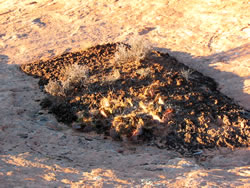
Cryptobiotic soil garden
|
|
|