HIKING HAPPENINGS October 2010
Upper Porcupine Rim – Panoramic Views of Castle Valley
by Marcy Hafner
 Emerging from beneath the slopes of the La Sal Mountains, the Porcupine Rim extends approximately twelve miles in a northwesterly direction before ending dramatically at the Colorado River. Most of its uplifted 2,000-foot backbone abuts the west side of Castle Valley - a sheer cliff wall of Kayenta Sandstone with a long distance drop to a steep slope of gigantic boulders and rubble that stretches to the edge of the valley floor. From a razor edged overlook on the Porcupine Rim Trail, the observation of Castle Valley and beyond is stunning. Emerging from beneath the slopes of the La Sal Mountains, the Porcupine Rim extends approximately twelve miles in a northwesterly direction before ending dramatically at the Colorado River. Most of its uplifted 2,000-foot backbone abuts the west side of Castle Valley - a sheer cliff wall of Kayenta Sandstone with a long distance drop to a steep slope of gigantic boulders and rubble that stretches to the edge of the valley floor. From a razor edged overlook on the Porcupine Rim Trail, the observation of Castle Valley and beyond is stunning.
The difficult challenge of these old jeep roads and trails have since been adopted and made popular by mountain bikers, but don’t let that reputation fool you. It’s a great place for hikers, too. Adjacent to a wilderness study area, the first 11.2 miles are open to motorized vehicles. After that it departs from the dirt road to become a single track suitable only for mountain biking and hiking. The uphill portion of the trail is a 900-foot ascent to the Castle Valley viewpoint. After that it is a 2800-foot descent to the Colorado River near the mouth of Negro Bill Canyon. The total distance of the trail is 14.4-miles and is most heavily used from March through late October. Due to the rim’s higher elevation (6800-feet), snow, rain and cold temperatures may occur during early spring and late fall and through the winter snow accumulates on its upper regions.
On the mesa leading up to the rim, early settlers observed an abundance of porcupines, hence the odd name for this spectacular landmark – a fact that surprised me immensely. Attracted by the pinyon pines, these slow moving quilled rodents gnawed off the outer bark to access the edible inner bark. If they girdled the trunk, the tree died.
To get to the Upper Porcupine Rim trailhead, turn east off Main Street at the Moab Information Center on to Center Street. At the stop sign on 400-east, take a right. Then drive a few blocks and turn left at Dave’s Corner Market on to Mill Creek Drive. At the three way stop – go straight on the Sand Flats Road, which will take you to the entrance station of the Sand Flats Recreation Area. From there it’s seven more miles to the trailhead, which is situated across from several cattle watering troughs. When the limited parking area is full, park along the north side of the main road.
 On a tempestuous partly cloudy, windy day at the very end of August, I start the three-mile ascent to the Castle Valley overlook. Despite the deceiving appearance of the various spurs that take off from the main trail, many are dead-ends. The main route, however, is well marked and easy to follow. This well-used segment of the trail, often visible for a long distance, is an obvious highway of buckled slickrock - a challenging obstacle course for bikers and jeepers. The ledges, however, present no difficulty for hikers. Negro Bill Canyon runs a parallel course directly below the trail and on this overly warm day, the cool looking cottonwoods and other water loving vegetation are so alluring. On a tempestuous partly cloudy, windy day at the very end of August, I start the three-mile ascent to the Castle Valley overlook. Despite the deceiving appearance of the various spurs that take off from the main trail, many are dead-ends. The main route, however, is well marked and easy to follow. This well-used segment of the trail, often visible for a long distance, is an obvious highway of buckled slickrock - a challenging obstacle course for bikers and jeepers. The ledges, however, present no difficulty for hikers. Negro Bill Canyon runs a parallel course directly below the trail and on this overly warm day, the cool looking cottonwoods and other water loving vegetation are so alluring.
The pinyon pines and juniper trees thrive at this elevation. The singleleaf ash happens to be a common species, too, but because of its diminutive small size, it is usually overlooked. These deciduous native trees, which only grow up to thirteen feet, are unique within the ash family because their smooth, oval-shaped leaves are single instead of compound. The contrasting colors of Indian paintbrush and goldenrod grab my attention because they are among the very last bloomers of the summer. The small yellow flowers of the broom snakeweed, which is arranged in a flat-topped broom-like cluster, are also a strong reminder that fall is on the way. It fascinates me that this perennial shrub was actually used as a broom by southwestern Indians and Mexicans.
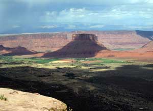
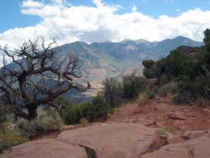
After a while the steady climb up on a 90-degree afternoon wears me out. The rim looks so tantalizingly close; yet feels so elusively far away and I wish I could fly as effortlessly as that turkey vulture circling above me! Eventually a glimpse of the high country convinces me I must be getting close. The road keeps swinging and swinging towards the rim until finally I am there!! Now I am more than ready for a long break to appreciate this fantastic view. At the valley’s upper end a few homes remain in Castleton, which had been an old mining camp and supply town for Miners Basin. In 1895 its population exceeded Moab and at that time it had been considered for the county seat of Grand County. The gray volcanic plug called Round Mountain protrudes sharply from the valley floor. Situated directly below me is Porcupine Ranch and looking further south I am observing the heart of picturesque Castle Valley with its homes, ranches and farms, which is bordered on the northeastern end by Parriott Mesa; named for Tom Parriott, the mail carrier for Castle Valley around the turn of the twentieth century.
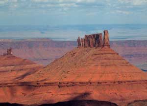 The striking rock formations of the Priest and Nuns and Castle Rock (also known as Castleton Towers) stand out in sharp relief above the valley floor while in the far background the indentation of the Colorado River corridor can be seen as it wanders through the Richardson Amphitheater. Glancing southeast are the prominent peaks of the northern range of the La Sal Mountains and the La Sal Loop Road below. The striking rock formations of the Priest and Nuns and Castle Rock (also known as Castleton Towers) stand out in sharp relief above the valley floor while in the far background the indentation of the Colorado River corridor can be seen as it wanders through the Richardson Amphitheater. Glancing southeast are the prominent peaks of the northern range of the La Sal Mountains and the La Sal Loop Road below.
When I finally tear myself around in a westward direction, I am gazing down upon a portion of Moab and the rugged outline of Behind The Rocks. Beyond that is the broad vistas of a canyonlands wilderness, which stretches out for miles and miles clear to the faint silhouette of the Henry Mountains on the far distant horizon.
The longer I stay, the windier it gets. This spot has turned into a hang on to your hat and everything else viewpoint. The dark angry thunderheads highlight the many red rock spires. The flickering of lightning sends off an ominous signal. I quickly get the lightning rod message that I shouldn’t dally any longer. Hastily I load up my pack and hot foot it down to a less exposed location. As I try to out run the rain, I keep thinking – what a sensational view I had just witnessed – that unique opportunity to be perched so high above Castle Valley.
|
Biological Soil Crust (aka)
Cryptos (krip’ tose):
The surface of
Moab’s desert is held
together by a thin skin of living organisms known as cryptobiotic
soil or cryptos. It has a lumpy black appearance, is very
fragile, and takes decades to heal when it has been damaged.
This soil is a critical part of the survival of the desert.
The cryptobiotic organisms help to stabilize the soil, hold
moisture, and provide protection for germination of the seeds
of other plants. Without it the dry areas of the west would
be much different. Although some disturbance is normal and
helps the soil to capture moisture, excessive disturbance
by hooves, bicycle tires and hiking boots has been shown
to destroy the cryptobiotic organisms and their contribution
to the soil. When you walk around Moab avoid crushing the
cryptos. Stay on trails, walk in washes, hop from stone to
stone. Whatever it takes, don’t crunch the cryptos
unless you absolutely have to! |

Cryptobiotic soil garden
|
|
|