The expansive, untamed landscape of Canyonlands National Park encompasses 527 square miles within the heart of the Colorado Plateau. Before park status, few except Native Americans, cowboys, river explorers and uranium prospectors entered into this rugged section of southeast Utah. Even today the majority of the park covers a wild, remote territory where bighorn sheep, coyote, deer and kit fox have enough undisturbed space to freely roam. 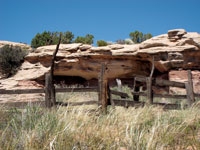
The Colorado and Green Rivers run through this dry desert land and their surging waters have carved out two large canyons - major barriers segmenting the park into three distinct areas – The Needles (south), The Maze (west) and Island In The Sky (north).
Island In The Sky, with an average elevation of 6,100 feet, is the highest district within the park. Situated like a desert island, this sheer-walled plateau is surrounded by a far-reaching, isolated landscape that drops 2,000 feet to the banks of the Colorado and Green. From a good vantage point, a person can cast his vision across miles 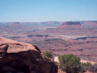 and miles of a tangled web of canyons, mesas, buttes, fins and spires. This wondrous horizon-to-horizon view is climaxed by three distinct mountain ranges - the La Sals to the east, the Abajos to the south and the Henry Mountains to the west.
When I was visiting the park last winter, a ranger told me that her favorite viewpoint is Murphy Point Overlook - a name given to a mile long promontory of land that is situated on the western end of Island In The Sky. Murphy Overlook is unusual, because it’s a walk-in instead of your typical quickie drive-in. This, however, is an easy-going 1.8 mile hike to the overlook, which gains only 100 feet – a comfortable stroll that provides me the opportunity to relax and observe nature’s pleasures up close for a more rewarding experience.
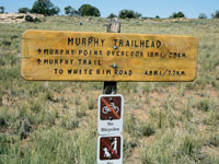 To get there, drive ten miles north of Moab on Highway 191. At Highway 313, turn left and drive another 25 miles to the park’s entrance station. After the visitor center, drive approximately five more miles. Then go straight at the stop sign towards Grand View Point and continue 2.5 more miles to the Murphy Trailhead.
The Murphy Point Trail used to be the Murphy Point Road – a sandy two-track, which was originally built by the ranching brothers, John and Otho Murphy in 1917. About two-tenths of a mile before the observation point the trail reaches the spot where drivers parked their vehicles for the short walk to the overlook. In 1996 the National Park Service proposed converting the road into a trail, which didn’t happen until a few years ago.
 From the late 1800’s until 1964 when Canyonlands became a national park, the shortage of water and forage made ranching in this land of minimal precipitation a difficult way of life. To keep their stock fed and watered, ranchers were forced to constantly rotate their cattle up and down steep canyons, such as Horse Thief Trail, Upheaval Canyon and Murphy Trail. This was a hard way to make a frugal living, but for those who endured, it became a place referred to as home.
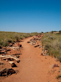
Shouldering my pack, I head out through the wide-open, windswept grassland on a trail lined with old cedar posts, which were put in by the park service for the purpose of clearly marking the route. I’m barely in my walking rhythm when I’m stopping to investigate an old corral. Built in the 1930’s by cowboys who spent their summers on this mesa, it has been left in arrested decay as a reminder of the park’s heritage.
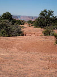
Walking through an abundance of Mormon tea, perennial grasses, sagebrush, blackbrush, yucca and Indian rice grass, I slow down to savor the wildflowers - yellow crypanth, pepper plant, silvery townsendia and the captivating lavender blooms of the Whipple’s fishhook cactus. Half a mile later, I arrive at the fork for the Murphy Hogback - a drop of 1,000 feet to the White Rim, which is still 4.2 miles down the trail. I happily swing right knowing that I only have a little over a mile left to my destination.
 |
 |
Eventually the logs lining the trail are replaced with cairns (piles of rocks), which guide me over the final portions of slickrock. Now I am traipsing past a stunted forest of pinyons and junipers. In this land of little water and fierce winds, these tenacious trees somehow manage to survive.
At the edge of the precipice, I stop for a blustery break to observe an overpowering view. Even though I am battered by the wind, I am still determined to stay long enough to absorb this extensive landscape.
While the wind tries to grab my hat and toss it away, I am scanning an overwhelming territory of sharp edges, abrupt drops and oddly shaped rock formations. Directly below, I am peering down on the White Rim – an obvious wide bench of sandstone at the top of the Cutler Formation, which was deposited 225 million years ago. The perceptible indentation of the White Rim Road wanders almost 100 miles over that sandstone bench. Another notable landmark is the Murphy Hogback - a long tongue of Moenkopi Shale that rises 200 feet above the White Rim Plateau.
Down in Stillwater Canyon, I am observing the Green River as it makes a loop around Turk’s Head. Above that, my eyes dwell on the unique formations of Candlestick Tower, Junction Butte and Ekker Butte. Looking straight across I recognize the well known figures of Chimney Rock in the midst of the Maze, and Cleopatra’s Chair above it to the north. Then further to the left, I can pick out the needle-point spires of Cedar Mesa Sandstone, which are characteristic of the Needles section of the park.
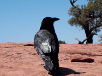
Gusts of wind keep threatening to throw me overboard. I’ve finally had enough! The time has come to move out of the way and find a more sheltered spot. Now I can eat my lunch without having to anchor everything down. While I’m enjoying a peanut butter and jelly sandwich, a trail mooching raven moves in to check out what’s for lunch! His beak is huge and I’m glad I’m not listed on the menu!
I shared this remarkable spot with a handful of people, who had left their vehicle and covered the distance. During my conversations with them, I was impressed with the freshness of their appreciative reactions to the overwhelming vastness and beauty of Canyonlands National Park.
