HIKING HAPPENINGS SEPTEMBER 2012 Clark’s Lake – An Idyllic Day The clanging of the alarm jars us out of bed - no sleeping in today! After a quick breakfast, we’re out the door. The race is on to beat the afternoon thunder boomers! Then cruising up the La Sal Loop Road, an unexpected event happens as we watch a full-grown mountain lion dart across the road directly in front of us! His shape and distinctively long tail was unmistakable.
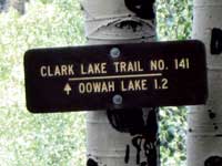
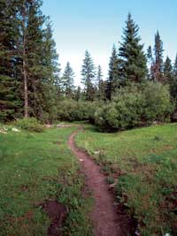
Many trails eventually lead to Clark’s Lake. The shortest route, however, is accessed from the Geyser Pass Road - 8/10ths of a mile beyond the turn off for Gold Basin. After the cattle guard, a large sign on the left prominently marks the trailhead. Clark’s Lake Trail # 141 is an old road that has been closed to motorized vehicles, but it remains open to hikers, horseback riders and mountain bikers. Within sight of the first sign, a second one informs me that it is 3.1 miles to Oowah Lake, which is two miles beyond Clark’s Lake, my goal for the day. On this heavily cloaked, moody-sky morning, an overnight shower has left the air with a lingering pungent dampness that hangs heavily on the lush green undergrowth. Within the wooded darkness, the accumulation of moisture steadily drips from the firs and spruce as a red squirrel belts out his loud screechy disapproval of my trespass on his property. Solitary and very territorial, his rapid-fire scolding is accented with violent jerks of the entire body and tail, which I find very amusing.
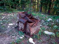
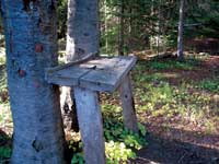
A cabin obviously stood in this appealing spot. Poking around I examine the remnants of an abandoned dwelling – scattered timbers, boards, rusty cans, a gasket, broken glass, mattress springs, wood stove, handmade tables and the likelihood of an old corral. As I search through the left-overs from a bygone era, I’d very much like to know - Who lived here and what story did they have to tell? Back on the trail sunshine is breaking through the clouds gradually erasing the morning chill. Now I’m sharply descending to a swift-moving creek, which has an old log for an easy crossing. Soon after that, I’ve reached the signed junction for the Moonlight Meadows Trail – right for Moonlight Meadows, left for Clark’s Lake.
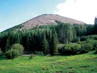
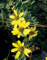
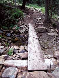
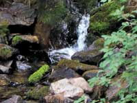
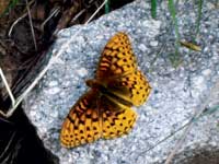
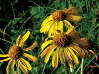
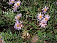
Continuing my stroll through a series of flower-filled meadows, the rounded hump of Haystack Mountain is now a steady vision to the north. Before long a wooden plank provides a “piece of cake” crossing over the next stream, where I pause to enjoy the lively rhythmic beauty of a small waterfall. The gradual descent now carries me through firs, spruce and aspens interspersed with a steady procession of meadows. The last stream crossing is dry – when flowing, it is bridged by a series of flat rocks. Eventually Upper Mill Creek - the source of Clark’s Lake - is directly below the trail where a rush of water produces a wealth of wildflowers. Nearby a fritillary butterfly rests on a rock waiting for the slow warmth of the sun to revitalize him – a golden opportunity to gaze very closely at his rich orange-brown coloring overlaid with a complex pattern of black stripes, bars and chevrons.
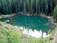
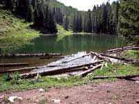
The trail continues above the creek until I’m peering down on the emerald green waters of the lake, which was named for Robert C. Clark. As an ambitious entrepreneur, he opened the first butcher shop in Moab with baked pies and homemade bread provided by his wife, Elberta - and the first ice delivery business in Moab using blocks of ice from the Colorado River. Clark was also one of the principals of the Moab Garage Company founded in 1917 - the first car agency in the valley selling Maxwells, Buicks and Chevrolets. If that wasn’t enough, he and Elberta operated the Ides Theater, which originally showed silent movies. At the yellow cattle-guard, I wander down the short trail to the lake - a perfect spot for a long break. I, however, keep a wary eye on the sky as I watch the turbulent clouds flow together in a passionate embrace, and then sever the relationship by splitting apart. I am fascinated with their constant transformation into puffballs, streamers and lacy curtains. In their expansiveness they gradually fill the sky as they develop into the dreaded thunderheads. But after awhile, those somber-looking clouds gentle out into more friendly ones – the danger of lightning has passed!
Now I can concentrate on what’s going on elsewhere - a dragonfly hovering above the water, small fry fish making tremendous jumps and butterflies languidly drifting from flower to flower. Comfortably relaxed I tune in to the rocking lullaby breeze that’s rustling the aspen leaves, the squawk of a Steller’s jay and mountain chickadees communicating their trademark “dee-dee-dee” calls.
|
|||||||||||||||||||||