HIKING HAPPENINGS April 2013
The Lazy-EZ Loop – Two Trails Wrapped Up Into One
by Marcy Hafner |
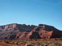 The big attraction for hiking the Moab Brand trails is the irresistible call of the wide-open big sky country - boundless miles of sweeping vistas flowing over a vast uplifted rocky land. In this immense landscape the Bookcliffs stretch endlessly along the northern horizon, while in the southeastern corner the dynamic wintry image of the La Sal Mountains is silhouetted against a deep blue sky. Looking westward, powerful Navajo Sandstone walls tower above Moab Canyon, followed by a continuous parade of intriguing book-ended cliffs promenading toward the western skyline. The big attraction for hiking the Moab Brand trails is the irresistible call of the wide-open big sky country - boundless miles of sweeping vistas flowing over a vast uplifted rocky land. In this immense landscape the Bookcliffs stretch endlessly along the northern horizon, while in the southeastern corner the dynamic wintry image of the La Sal Mountains is silhouetted against a deep blue sky. Looking westward, powerful Navajo Sandstone walls tower above Moab Canyon, followed by a continuous parade of intriguing book-ended cliffs promenading toward the western skyline.
The Bar M, Circle O, Rocking A and Bar B are the cattle brand names for these original four trails, and the single letters have been cleverly arranged to spell MOAB. Adding more spice to this nostalgic cowboy lingo, the sidekick trails of the Lazy-EZ, Killer B, Long Branch, North 40 and Deadman’s Ridge provide an extensive network of nine interconnecting non-motorized routes, which were recently completed by the Moab Trail Mix Committee, a volunteer group sponsored by Grand County.
To get to the Moab Brand trailhead, drive north out of town on Highway 191 for nine miles and turn right at the signs for the Bar M Chuckwagon and Bar M Trails. Then, swing a sharp right to go directly south on a graveled dirt road that has a speed limit of ten mph. In about a half mile, the paved Colorado River-Gemini Bridges bike/pedestrian pathway comes in under the highway through a culvert and continues its course alongside the dirt road. As bike path and road run their parallel course, only a wire fence separates them, and at this merger the road has narrowed down to one lane, with strategically placed pullouts to avoid oncoming traffic.
 It is interesting to note that the dirt road I am driving on was the old highway to Moab. In the 1880s, it took eight hours by wagon trail over this dirt track to deliver mail and supplies from the railroad stop in Thompson. The first long distance travelers by automobile – a trek that started in Nebraska - arrived in town in 1909 over a road that was nothing more than a wagon trail! Despite it being designated a state highway in 1910, conditions didn’t change until 1919, when federal funds became available to improve the “post” roads for the delivery of the US Mail. In the early 1920s, 25 prisoners blasted out the current route through Moab Canyon - “improved” then meant graded dirt or gravel – a huge contrast to the paved highway we so easily and quickly travel on today. It is interesting to note that the dirt road I am driving on was the old highway to Moab. In the 1880s, it took eight hours by wagon trail over this dirt track to deliver mail and supplies from the railroad stop in Thompson. The first long distance travelers by automobile – a trek that started in Nebraska - arrived in town in 1909 over a road that was nothing more than a wagon trail! Despite it being designated a state highway in 1910, conditions didn’t change until 1919, when federal funds became available to improve the “post” roads for the delivery of the US Mail. In the early 1920s, 25 prisoners blasted out the current route through Moab Canyon - “improved” then meant graded dirt or gravel – a huge contrast to the paved highway we so easily and quickly travel on today.
After two miles the roadways split and the 8.5 mile pathway continues into Moab Valley, while the dirt road turns east. Soon after, a four-wheel drive high clearance vehicle is needed to negotiate a short steep segment of jumbled rocks, but parking is available before that at the bulletin board, with overflow parking immediately to the left.
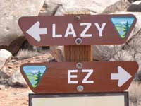 At last the snow and mud are gone, a quagmire no longer exists, and I am in the mood for an easy-going hike on The Lazy-EZ, a 2.75 mile loop that was designed for beginning mountain bikers. This loop is uniquely divided into two separate trails as the EZ runs a parallel course directly west of the Lazy. To access it, I walk a short distance east on the Bar M trail. Passing up the sign for the EZ, I continue a little further to start the counterclockwise loop on the Lazy, a northerly course that gently wanders upward through a series of mini-ridges in a landscape dominated by junipers, blackbrush and Mormon tea. At last the snow and mud are gone, a quagmire no longer exists, and I am in the mood for an easy-going hike on The Lazy-EZ, a 2.75 mile loop that was designed for beginning mountain bikers. This loop is uniquely divided into two separate trails as the EZ runs a parallel course directly west of the Lazy. To access it, I walk a short distance east on the Bar M trail. Passing up the sign for the EZ, I continue a little further to start the counterclockwise loop on the Lazy, a northerly course that gently wanders upward through a series of mini-ridges in a landscape dominated by junipers, blackbrush and Mormon tea.
On this gentle-on-your feet uphill stroll, I gradually reach a crest in the trail where those telltale sights of the modern world disappear. As I step down to the less civilized side, I am transported to another dimension as the magical profiles of The Windows and Balanced Rock in Arches National Park pop into view. In this setting of incredible depth and beauty, highlighted by the La Sal Mountains, the corridor of Courthouse Wash can also be seen, and it is worth the short walk over gray slickrock to peer down on the sheer walls that enclose the width of this canyon.
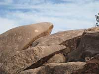
On this mostly cloudy sun-filtered day a scene this spectacular deserves a more concentrated look, and a slanted rock provides a comfortable backrest. Cherishing this undisturbed time of contemplation and relaxation when the trails are still relatively empty, my attention now turns to the limitless land of rocks - a gigantic playground of rocks, rocks, and more rocks – up-ended rocks, sharply pointed rocks, little rocks, big boulder-size rocks and huge piles of rocks that cover an expansive terrain of rich brown-colored earth.
With the promise of spring in the air I have no desire to leave, and so linger for as long as I can, savoring these changing-of-the season days - looking forward to warmer temperatures - blooming wildflowers - the big spring migration – more daylight - and the raucous 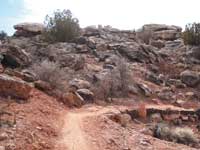 chorus of birds, all of which is just around the corner. chorus of birds, all of which is just around the corner.
With a sigh, I finally push myself up to what remains on the rest of the trail as it slowly pokes down to the lowlands. It doesn’t take long before I’m at the sign for the switchover from the Lazy to the EZ. Now, changing course from north to south it is smooth sailing all the way back to the trailhead where I am greeted by the heavenly blue of a small flock of mountain bluebirds. A chance meeting with these lovely thrushes, charming cousins of the robin, provides a gratifying bird watching experience for the ending of this delightful hike.
|
Biological Soil Crust (aka)
Cryptos (krip’ tose):
The surface of
Moab’s desert is held
together by a thin skin of living organisms known as cryptobiotic
soil or cryptos. It has a lumpy black appearance, is very
fragile, and takes decades to heal when it has been damaged.
This soil is a critical part of the survival of the desert.
The cryptobiotic organisms help to stabilize the soil, hold
moisture, and provide protection for germination of the seeds
of other plants. Without it the dry areas of the west would
be much different. Although some disturbance is normal and
helps the soil to capture moisture, excessive disturbance
by hooves, bicycle tires and hiking boots has been shown
to destroy the cryptobiotic organisms and their contribution
to the soil. When you walk around Moab avoid crushing the
cryptos. Stay on trails, walk in washes, hop from stone to
stone. Whatever it takes, don’t crunch the cryptos
unless you absolutely have to! |
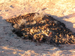
Cryptobiotic soil garden
|
|
|