HIKING HAPPENINGS June 2013
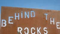
Behind The Rocks - Another Tale Of Two Arches
by Marcy Hafner |
When I get up in the morning and look across the floor of Spanish Valley, the jagged profile of the Moab Rim is always there to greet me - a geological wonder that never ceases to amaze me. After all, how could I possibly get bored with the powerful stance of this 1800 foot Navajo Sandstone precipice dominating Moab’s southwestern skyline? Beyond the walls of this formidable fortress, known as Behind The Rocks, is a remote and rugged wilderness – a precious resource in which 12,635 acres have been designated as a Wilderness Study Area - a mysterious maze spanning miles and miles of slickrock, fins, domes, hidden gardens, giant caverns, deep pools, sharply cut canyons and numerous arches.
On this beautiful spring day I am raring to be off for an invigorating hike in the southern end of this spectacular region to visit two uniquely different arches – Moab Rim Arch and Tukuhnikivista Arch. Arches are fascinating geological creations and water erosion is usually the main factor in their formation. It all begins at weak points within the sandstone when chemicals in the water dissolve the cement that was binding the rock particles. Then expanding pressure from water and ice slowly breaks off pieces of stone until many of the fins collapse. But some with the right balance and hardness have survived as arches, and geologists believe that most of them were created within the last million years.
 My access point is 12 miles south of Moab on Highway 191. When the road starts uphill, I take a right on a dirt road just before mile marker 114. After driving a very short distance, I conveniently park at the Behind The Rocks jeep trail sign. My access point is 12 miles south of Moab on Highway 191. When the road starts uphill, I take a right on a dirt road just before mile marker 114. After driving a very short distance, I conveniently park at the Behind The Rocks jeep trail sign.
Another well-used entrance at the top of Blue Hill is 1.4 miles further down the highway. Heading north this dirt road, which will get you very close to the arches, eventually requires a high clearance four-wheel drive vehicle. I, however, prefer to walk, rather than jounce around, and this route I am taking is the shortest, least crowded and most direct for a hiker.
Grabbing my pack, I start walking over a very extreme – How they do it? - jeep trail, but the path of black over the rock ledges proves it’s been done many times! Traipsing through the pinyons, junipers, blackbrush, cliffrose and rabbitbrush, I stroll past the nostalgic remnants of a fence line as I tune into a very vocal pair of house finches.
Gradually the road ends at an intersection, and I take a right following the Behind The Rocks sign. At the beginning of this undulating section the lofty snow-covered silhouette of the Abajo Mountains, on the southwestern horizon, and the distinctive outline of Black Ridge, to the southeast, suddenly pop into view.
 Staying on the main road I pass by a fork until I reach another intersection, where I continue straight on a dead end road rather than hang a left, skirting the boundary of the Behind The Rocks Wilderness Study Area. Now the road drops steeply as it snakes a course along the rim, where rock formations of all sizes and shapes engulf me - protruding towers - hefty blocks – sharp jagged edges - rounded monoliths - and an endless series of lumpy, bumpy rocks. Staying on the main road I pass by a fork until I reach another intersection, where I continue straight on a dead end road rather than hang a left, skirting the boundary of the Behind The Rocks Wilderness Study Area. Now the road drops steeply as it snakes a course along the rim, where rock formations of all sizes and shapes engulf me - protruding towers - hefty blocks – sharp jagged edges - rounded monoliths - and an endless series of lumpy, bumpy rocks.
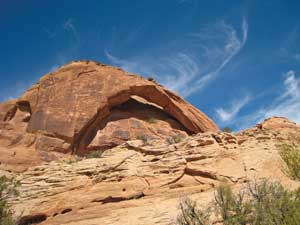
Finally the Moab Rim Arch: At first glance it looks like a huge alcove - but when I see daylight pouring through, it dawns on me I am standing beneath a monster-sized arch. Now that I have achieved my first goal I am ready for a break, and I plop down to give this massive span my undivided attention. Gradually the thick veil of cottony clouds drifts away leaving behind a peaceful blue sky that contrasts sharply with the warm brown richness of this arch. Sitting under this immense opening savoring the scene, I am treated to the enchanting three note song of a black-throated sparrow.
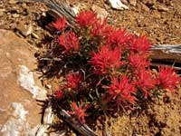 After that refreshing interlude, I continue down the road pausing often to soak in the brilliant red beauty of Indian paintbrush. Before long I’m staring at the odd shape of Tukuhnikvista Arch on the skyline - a curvature above the rock wall that has the striking appearance of a bent over finger - so small and fragile looking, I feel like a brisk wind could knock it over. After that refreshing interlude, I continue down the road pausing often to soak in the brilliant red beauty of Indian paintbrush. Before long I’m staring at the odd shape of Tukuhnikvista Arch on the skyline - a curvature above the rock wall that has the striking appearance of a bent over finger - so small and fragile looking, I feel like a brisk wind could knock it over.
The road ends, and seeking the best route to this arch I pick my way over a faint trail of footprints angling to the right through some fins. At a wall of steep slickrock, I lose the trail and just keep heading for the ridge. After a lot of exertion, the top looks so close and yet it feels so far away! Step by step, however, I forge on, following the course of least resistance, where two rock cairns offer hope I’m still on track, even though the arch has disappeared from view. Suddenly it shows up again, and from this particular angle it resembles a horse’s head.
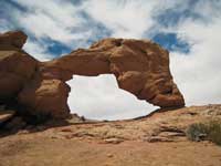 Finally, I’m on the skyline. After a short stroll south, I’m standing next to this teeny-weeny arch. Wow! Determination has paid off! I feel like celebrating with a glass of champagne! Settling down for a long lunch break in the embracing arms of this small opening I can picture-frame Mt. Tukuhnikivatz, the feature that gave this arch its curious name. Finally, I’m on the skyline. After a short stroll south, I’m standing next to this teeny-weeny arch. Wow! Determination has paid off! I feel like celebrating with a glass of champagne! Settling down for a long lunch break in the embracing arms of this small opening I can picture-frame Mt. Tukuhnikivatz, the feature that gave this arch its curious name.
Content on my bird’s eye perch I survey my surroundings, where to the east I am peering down on the Ken’s Lake campground, the road to Flat Pass, Mill Creek Canyon, the La Sal Mountain range, Pack Creek Ranch and the busy ribbon of traffic on Highway 191. Shifting my gaze west, no long distance view: instead my vision bumps up against the next rock wall with its crevices, indentations, the defining edges of its rough texture.
This scene atop the backbone of Behind The Rocks is too special to be rushed, and so I linger awhile contemplating the tale of two very different arches – the shy hidden giant versus the cocky midget that jauntily stands out on the skyline. Each has its own special personality and appeal, which is what has made this journey so intriguing.
|
Biological Soil Crust (aka)
Cryptos (krip’ tose):
The surface of
Moab’s desert is held
together by a thin skin of living organisms known as cryptobiotic
soil or cryptos. It has a lumpy black appearance, is very
fragile, and takes decades to heal when it has been damaged.
This soil is a critical part of the survival of the desert.
The cryptobiotic organisms help to stabilize the soil, hold
moisture, and provide protection for germination of the seeds
of other plants. Without it the dry areas of the west would
be much different. Although some disturbance is normal and
helps the soil to capture moisture, excessive disturbance
by hooves, bicycle tires and hiking boots has been shown
to destroy the cryptobiotic organisms and their contribution
to the soil. When you walk around Moab avoid crushing the
cryptos. Stay on trails, walk in washes, hop from stone to
stone. Whatever it takes, don’t crunch the cryptos
unless you absolutely have to! |
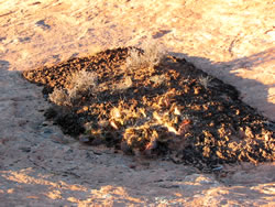
Cryptobiotic soil garden
|
|
|