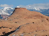
 On this foot-stomping, finger-numbing morning, it is hard to believe that approximately 150 million years ago during the Jurassic period the Colorado Plateau was situated near the equator! Yes, on this wintry day I am finding it difficult to wrap my head around the fact that where I am now standing used to be a Sahara-like desert, an empty land filled with shifting dunes of sand. Then over a long geologic span those restless grains of sand petrified into Navajo sandstone, leaving behind the rounded slickrock that is so characteristic of what we see here today in the Sand Flats Recreation Area.
Even though it is famous for the Slickrock and Porcupine Rim bike trails, as well as almost 40 miles of jeep trails, don’t let that biker-jeeper perception mislead you. The hiking opportunities, especially in the quietude of winter, shouldn’t be overlooked.
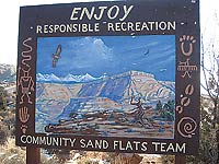
 Touching its borders with two wilderness study areas – Negro Bill to the north, Mill Creek to the south – this popular playground receives over 100,000 visitors a year. Responding to the recreational overload, in 1995 the community, AmeriCorps, Grand County and the Bureau of Land Management (BLM) collaborated to protect this vital resource. Consequently an unusual partnership was formed between the county and the BLM so they could maintain, manage and rehabilitate its 7,320 acres.
To get there, turn east off of Main Street at the Moab Information Center on to Center Street. At the stop sign on 400 East, go right. Then drive five blocks and turn left at Dave’s Corner Market on to Mill Creek Drive. At the three-way stop, go straight and drive 1.7 miles on the Sand Flats Road to the entrance booth.
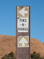
 The entire Fins & Things jeep trail is 9.4 miles long, but since it parallels the Sand Flats Road you can enter and exit at various intervals for a much shorter hike. On a brilliantly clear day in early January I am embarking on a hike on the north loop of Fins and Things, which starts 1.5 miles beyond the entrance station.
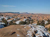
At the trailhead marked with a “you are here” map I can’t help myself – despite the chill - from pausing to behold an engulfing panoramic picture postcard scene - the mystic vision of the snowy cloud-covered La Sal Mountains - the jagged outline of Behind The Rocks - the notch-shaped indentation on the Portal’s cliff-face - a bumpy-edged, flat-topped formation that reminds me of a necklace - the long sweep of the Porcupine Rim and South Mesa – the deep canyon on the north end of Moab Valley - and the far reaching undulating slickrock hills.
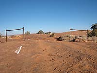
 It is, however, a tad too cold to stand around. Unless the temperature swings up dramatically, this particular hike is not going to be a leisurely stroll! And thus at an opening in the barbed wire fence I start to prance through patches of snow following the alternating white Vs, white dots and white dinosaurs painted on the slickrock.
I haven’t gone far when unexpectedly over the first hump there they are - those tremendous fortress-like formations in Arches National Park! Soon after covering more ground I am able to pick out the cavernous gap of Abyss, a side canyon of Negro Bill.
At the first two forks I take a right upon discovering that the snowy steep grades on the left forks are too treacherous to walk on. If I’ve guessed correctly I will eventually end up at the radio tower. I can see this familiar landmark directly ahead, tantalizingly close as the crow flies, but jeep trails seldom have the option of taking the most direct route. This one in particular has a bad case of the loop-de-loops! When I start going backwards, I wonder if I am really on the right track.
I constantly remind myself not to turn back - just be patient and keep on going! Eventually my persistence pays off. After a whole maze of loop-de-loops, the road does straighten out – at last, it is going in the right direction!
 And now - way off yonder – almost like a mirage – there’s an amazing sight - The Three Gossips in Arches National Park. That name, those distinctive shapes, always stir my imagination.
Before long another uphill jaunt leads me to the boundary of the Negro Bill Wilderness Study Area, and shortly after that I wind up at the final junction with no signs and numerous choices. By now I am so close to the radio tower it feels like I can almost reach out and touch it; instinctively I veer off in that direction.
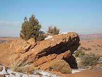
Now on the home stretch it has finally warmed up enough – just barely! - for me to take a very late lunch break. Hunkering down in a slight depression I greedily soak up the solar rays, while trying hard to ignore a chilling breeze. Underneath the ceiling of a deep-blue-winter sky I snuggle up amidst the pinyons and junipers savoring the coziness of this sheltered spot. In my tiny haven I can relish the perception of being far, far away from civilization in a place where precious solitude is so soothing – no traffic – no voices – no intrusions. The only sounds to be heard are the booming voices of ravens, the titillating chatter of juncos and the distant barking of a dog - a perfect place to enjoy a wonderful off-season interlude.
 The penetrating cool air eventually sends me on my way, but I don’t have far to go as
I start pacing up the final hill to the tower. A short downhill and I’m on the main road, with just a half-mile left to get to my car completing a loop of approximately three delightful, refreshing miles.
A quick ten minute drive out of town makes this year round treasure ideal for spontaneous outings. Overly crowded in the spring, still wildly popular in the fall, Sand Flats shows its most welcoming face during the off-season serenity of winter, when it transports the solitude-seeking hiker to a dramatic big picture perspective that extends for miles and miles in all directions.