|
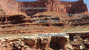 |
| Resistance to erosion is always relative. Here harder (White Rim and Wingate sandstones) and softer (Moenkopi and Chinle formations) in Canyonlands National Park. Thin sandstones in the Chinle hold up vertical ledges. |
Within its overall theme of canyons and cliffs, the landscape of southeastern Utah has a great deal of diversity. Arches National Park is different from Canyonlands National Park, which in turn is distinct from Bryce or Zion. Even at finer scales, there is variation in the scenery and landforms of any given location and even within a single cliff face or rock spire.
What all these places and landforms have in common is that they are the product of arid-land erosion. Erosion consists of the processes that loosen and wear away rock material and then transport them. Weathering (rock decay) is in situ (in place) disintegration and chemical breakdown of rock that often precedes erosion or happens concurrently with it. In an arid environment like near Moab, weathering rates are often low, whereas erosion rates may be relatively higher, especially on steep slopes and during storms and flash floods.
However, these processes do not occur at the same rates on different rock types; if they did, the landscape would be much more uniform. For example, cliffs and ledges wouldn’t break up slopes, and intricately carved hoodoos and pedestal rocks would not exist.
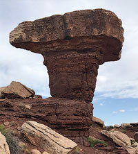 |
| Harder White Rim Sandstone caps pillars of the relatively softer Organ Rock Formation forming a mushroom or pedestal rock. |
Differential erosion is erosion that occurs at varying rates depending on the characteristics of the rocks that it is acting upon. Erosion works more slowly on rocks that are harder and more resistant. It proceeds more rapidly on rock types that are softer or less resistant. Hence, the variety of the rock types present in southeastern Utah and how they respond to weathering and erosion is responsible for much of the variation of the landforms here.
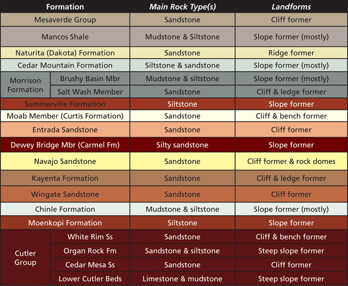
Almost all of the rocks exposed throughout canyon country are sedimentary. As a general rule, sandstones and limestones are more resistant to erosion and erode away more slowly than shale, mudstone, or siltstone, which are more erodible. Harder rock types hold up cliffs, and form ledges or broad benches. Softer mudstones or siltstones form slopes.
Each of the different rock layers (formations to geologists) present in southeastern Utah tends to form its own characteristic style of landforms depending on its predominant rock type(s), along with other features such as how thick its bedding (internal layering) is and its overall thickness.
Massive sandstones like the Wingate, Entrada, or Navajo are resistant to erosion and form cliffs and rock domes. Layers that include a lot of siltstone or mudstone make slopes. The Moenkopi and Chinle formations and the Mancos Shale are among the major slope formers here.
Some rock layers contain multiple rock types and this variability can change its geomorphic expression (e.g., the shape of the landforms it creates). For example, the Chinle Formation consists mostly of siltstone and mudstone, but it also contains some thin sandstone beds. These thin sandstones make abrupt ledges that breakup the slopes made by the Chinle mudstones and siltstones.
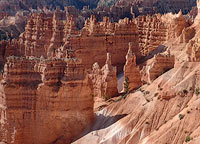 |
| Hoodoos in Bryce Canyon National Park. |
The White Rim Sandstone is one of the hardest rock layers in southeastern Utah. The broad bench known as the White Rim in Canyonlands National Park is held up by this rock layer. The much softer the Moenkopi and Chinle Formations above it have been removed by erosion except where they have been protected from erosion by harder layers above them (Wingate Sandstone and Kayenta Formation) that hold up the Island in the Sky mesa. The White Rim and then the slopes and cliffs of the Island in the Sky result from the varying resistance of the rock layers that make each part of this canyon stairstep.
Slight variations in the hardness of beds within a single formation can yield create undulating rock spires known as hoodoos. The hoodoos in the Claron Formation in Bryce Canyon National Park are classics of the form: minor differences in the hardness or softness of the Claron’s thin beds have yielded fanciful columns that create a wonderland of rock.
It is said that variety is the spice of life. In the evolution of canyon landscapes, variety in rock types and minor differences in their resistance to erosion provides much of the interest and beauty of this area’s scenery. Given the overall high elevation and the major rivers incising into the land, there would still be deep canyons here. But without alternating harder and softer layers, there would just be monotonous canyon walls from river to rim.
|
 A self-described “rock nerd,” Allyson Mathis is a geologist, informal geoscience educator and science writer living in Moab.
 Spend the weekend in scenic Green River, Utah, for the sixth annual Green River Rocks! Hosted by Epicenter on the grounds of the John Wesley Powell River History Museum from April 5th-7th, the festival is free and open to the public, and will feature expert-led natural history field trips, rock and mineral vendors, educational activities, and fun for the whole family. Green River Rocks brings awareness to and fosters appreciation of rural places, wilderness, unique sites, and overlooked histories. Specifically, the festival seeks to highlight the area around Green River, Utah, and the stories of this remote place, its people, and cultures; and nearby significant geological, paleontological, and archeological sites. The weekend-long festival, is hosted by Epicenter and the Bureau of Land Management.