In and around Moab, rocks are one thing that no one can miss. Moab itself is surrounded by rock walls in two lines of cliffs that stretch from the northwest to the southeast. Nearby, Arches and Canyonlands national parks feature more rock sculptured into fantastic forms and displaying a wide array of color from white to red to orange to pink to gray and even to green. From Dead Horse Point, we look down on a whole tableau of rock surrounding the Colorado River below.
 This is, in short, a landscape of rock. And much of the human history of southeastern Utah has been shaped by geology. The literature of the region is likewise based on geology. Edward Abbey wrote at the start of Desert Solitaire of watching sunrise over Balanced Rock in Arches, and the geology of the park is arguably the second most important character in his memoir beyond himself. Among the greatest challenges that pioneers and early settlers in southern Utah faced were ones made of rock. Geology determined where the roads and travel routes were, where water was found, and even the location of towns and settlements. The Hole-in-the-Rock expedition serves as a prime example of the influence of geology on historic events.
Perhaps the most apt written description of this area goes back to geologist and explorer John Wesley Powell who completed the first descent of the Green and Colorado rivers in 1869, when much of the area was still the “great unknown.” Describing the landscape in what is now Canyonlands National Park, he wrote:
“The landscape everywhere, away from the river, is of rock—cliffs of rock, tables of rock, plateaus of rock, terraces of rock, crags of rock—ten thousand strangely carved forms; rocks everywhere, and no vegetation, no soil, no sand.”
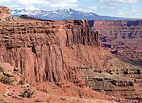 True, Powell exaggerated somewhat as he was wont to do. There may easily be ten thousand strangely carved forms, but vegetation, soil and sand all are present. Vegetation dots the landscape, although it tends to be limited and somewhat subdued compared to that found in wetter climes. Unlike the scenery of prairies, valleys and mountains (except above tree line) where plants predominate, exposed bedrock is the defining feature of almost any scene in canyon country, with the exceptions of a colorful spray of wildflowers or a lone juniper tree emerging from a crack in slickrock. Soils are present in many areas, but are usually thin. And there is most certainly sand, as anyone who has experienced a windy spring day can attest.
We don’t have to consult a dictionary or a geology textbook to know what rock is. It is the solid mineral material that makes up Earth’s surface. Geologists study rocks, tracing the planet’s history and processes that shape it, ranging from slow events like weathering and erosion to rapid ones such as volcanic eruptions and earthquakes. 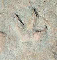
Rocks are the building blocks of the spectacular red rock desert surrounding Moab, but they are also history books, habitats for plants and animals and the source of raw materials that we use in our daily lives.
The physical characteristics of rocks determine the shape of the landscape. These characteristics include how resistant the rocks are to erosion, and whether they are cut by fractures or joints, displaced by faults, or have been tilted or folded. In the Moab region, harder layers of sandstone such as the Wingate Sandstone sit atop softer siltstones and shales of the Chinle Formation. The hard Wingate Sandstone stands up vertically, forming mile upon mile of canyon rim, while the slopes of the Chinle Formation are usually obscured by debris produced from rock falls that likely initiated on vertical joints in the Wingate Sandstone.
Rocks also hold clues that tell geologists how they were formed. Author John McPhee described rocks as “windows into the world as it was at other times.” Geologists look through these windows by studying fossils or intricate patterns within rocks that act as detailed codes that yield insights into the deep history of our planet. The rocks around Moab hold evidence of ancient environments ranging from large sand dune systems like the modern Sahara Desert to immense river systems that transported large quantities of logs that became buried and, over eons, fossilized into petrified wood. Tracks left millions of years ago on beaches or riverbanks tell us that what is now the high desert was once the home of dinosaurs. Desiccation cracks preserved in rocks tell the story of environmental change millions of years ago.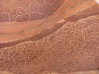
The study of geology allows us to travel back millions of years in time and understand geologic processes that we may not witness on a day-to-day basis. In many ways, geology is the fundamental science for this landscape of rock. This new Geology Happenings column will hopefully serve as a guide to this amazing place. Each month we will examine an aspect of the local geology with the goal of telling geologic stories while explaining how the science of geology works. We will cover a diversity of topics, sometimes focusing on a single rock layer or geologic site, while other columns may overview large complex topics such as the uplift of the Colorado Plateau. The canyon country is a delight to geologists and non-geologists alike, and I am thrilled to have this opportunity to explore this landscape and its rocks with you.
You can read more geology articles from Allyson HERE
A self-described “rock nerd,” Allyson Mathis is a geologist, informal geoscience educator and science writer living in Moab.
A flat-lander by birth from where everything was covered with vegetation, Allyson is much happier exploring deep time in Moab and beyond. |
 |
.