|
|
Geology HAPPENINGS April 2019 |
Earthquakes and Moab
by Allyson Mathis |
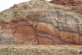 |
| Minor splays or branches of the Moab Fault near the Arches Visitor Center. |
At 10:22 am on Monday, March 4, 2019, the ground shook in Moab, something that doesn’t happen often in this mostly seismically-sleepy section of the Colorado Plateau. Many Moab residents felt movement from the 4.5-magnitude earthquake located approximately 35 miles to the southeast near Bedrock, Colorado. While the cause of this particular earthquake was likely due to injection of brine from the Bureau of Reclamation’s desalination plant near the epicenter, it provides a good opportunity to explore the subject of earthquakes and why they are rarely felt in the Moab area.
Earthquakes are sudden motions or tremblings in the earth, caused by abrupt movement along faults or by movement of magma underneath volcanoes. Faults are fractures where blocks of the earth’s crust have moved relative to one another. Faults may have displacements ranging from a few inches to hundreds of miles. Earthquakes may occur anywhere, but large quakes are generally located at the boundaries between tectonic plates (large rigid pieces of the earth’s outer layer) where plates slide past one another (such as at the San Andreas Fault in California) or slip underneath one another (such as in Japan where the 2011 Tohoku earthquake caused a catastrophic tsunami and the meltdown of the Fukushima nuclear plant).
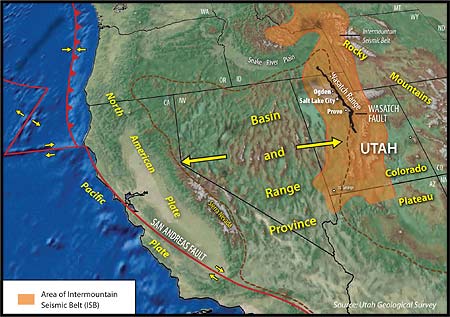 |
| The Intermountain Seismic Belt is on the eastern boundary of the Basin and Range. Image slightly modified from original by the Utah Geological Survey |
Some areas located far from plate boundaries also can be tectonically active, either because of current strains and stresses acting on the crust or in areas where the crust has otherwise been weakened. The New Madrid Seismic Zone in Missouri is one place where large intraplate earthquakes have occurred. A series of quakes in 1811 and 1812 with magnitudes as large as 7.7 were felt over broad swaths of the central United States and even caused a “fluvial tsunami” which made it appear as if the Mississippi River was flowing upstream for several hours.
The Wasatch Front is a good example of a tectonically-active intraplate area far from the plate boundaries on the west coast. The Wasatch Fault is part of the Intermountain Seismic Belt that 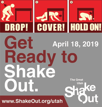 extends north-south from Montana to northern Arizona and is related to the stretching of the North American continent that formed the Basin and Range Province in Nevada and western Utah. Geologists think that earthquakes as large as 7.5 magnitude may occur in the Intermountain Seismic Belt in Utah, creating significant risk to the approximately 2.3 million Utahns who live close to the faults. extends north-south from Montana to northern Arizona and is related to the stretching of the North American continent that formed the Basin and Range Province in Nevada and western Utah. Geologists think that earthquakes as large as 7.5 magnitude may occur in the Intermountain Seismic Belt in Utah, creating significant risk to the approximately 2.3 million Utahns who live close to the faults.
If (when) a large earthquake occurs in the Intermountain Seismic Belt, some shaking may be felt in Moab, but Moab is far enough away from the Intermountain Seismic Belt that direct impacts in our immediate area will be minimal. For example, a magnitude 5.3 earthquake in August 1988 in the San Rafael Swell with an epicenter near Castle Dale in Emery County was felt in southeastern Utah, but caused no reported damage here although rockfalls did occur.
Because of the risk that exists from damaging earthquakes in the state, the Great Utah ShakeOut, an earthquake preparedness drill, will take place at 10:15 am on Thursday, April 18. 2019. During the ShakeOut, individual participants will practice how they will Drop, Cover and Hold On during a quake, and agencies, organizations, schools and businesses will take part in more extensive earthquake scenarios. Nearly a million people in Utah participated in the 2018 Great Utah ShakeOut. To learn more and to register for the 2019 event, visit https://www.shakeout.org/utah/.
The March 4 - Bedrock, Colorado Earthquake
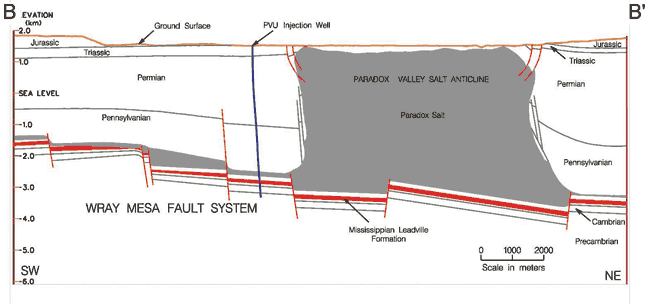
The recent Bedrock earthquake was most likely not tectonic in origin, but instead caused by deep injection of brine as part of the effort to keep salt out of the Colorado River. The Bureau of Reclamation injects extremely saline groundwater from the Paradox Valley approximately 16,000 feet deep into the Leadville Limestone near the Wray Mesa Fault System.
Some injection wells, such as the one at Paradox, can cause earthquakes by increasing pore pressure on nearby faults thereby weakening them, making them more susceptible to slippage. Many injection wells that have caused induced earthquakes such the recent ones in Oklahoma (a state that has very low natural seismic hazard) dispose of wastewater from oil and gas production (fracking itself is much less likely to induce earthquakes because the lesser volumes involved and shorter durations of the operation).
Through 2016, more than 6,400 shallow earthquakes had been recorded near Paradox Valley since 1991 when brine injection began, with no earthquakes recorded during the six previous years. If the March 4 earthquake is related to brine injection (as is very likely), it will be the largest quake associated with the Paradox site to date. The largest previous quake was magnitude 4.4 in 2013. The 2019 quake was followed by 20 smaller aftershocks with magnitudes between 1.4 and 2.4 in the following two weeks that were recorded by University of Utah seismometers including one in the Grand County Courthouse. Numerous smaller aftershocks also likely occurred.
|
 |
| |
Image is from Bureau of Reclamation Technical Memorandum TM-85-833000-2017-22 |
|
You can read more geology articles from Allyson HERE
A self-described “rock nerd,” Allyson Mathis is a geologist, informal geoscience educator and science writer living in Moab.
A flat-lander by birth from where everything was covered with vegetation, Allyson is much happier exploring deep time in Moab and beyond. |
 |
|
|
|
|
|
|
|
© 2002-2024 Moab Happenings. All rights
reserved.
Reproduction of information contained in this site is
expressly prohibited.
|
|