-paradox-Joel-Pederson-photo.jpg) |
| The Paradox Formation exposed adjacent to the Kane Creek Road. photograph courtesy of Joel Pederson, Utah State University |
The ancient geologic past relates to aspects of the canyon country surrounding Moab in so many ways. It determines where we live or camp, where wildlife is found, and the locations of springs, those rare desert water sources. Despite the prevalence of geologic controls on the landscape, one of the most direct and obvious linkages between geologic past and present in the Moab area is the occurrence of mineral resources, such as those mined by Intrepid Potash at a site approximately 15 miles south of Moab.
Potash is a generic term for any potassium salt. Intrepid Potash mines potassium chloride (the mineral sylvite) from the Paradox Formation that was deposited approximately 310 million years ago. Although there are only limited surface exposures of the Paradox Formation in southeastern Utah, it is one of the area’s most significant rock layers, and it has an essential role in many features found throughout canyon country. Of key importance are the unit’s thick deposits of evaporate minerals including salt (sodium chloride; the mineral halite) and potash.
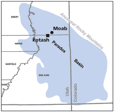
The Paradox Formation was deposited in the Paradox Basin, a restricted marine basin southwest of the Ancestral Rocky Mountains. The Paradox Basin was a deep asymmetric downwarping that was formed by the same tectonic forces that raised the Ancestral Rockies. The Paradox Basin shallowed to the southwest before connecting to the open ocean, during The Pennsylvanian Period, a warm interval of geologic history when sea levels were generally much higher than today.
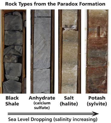
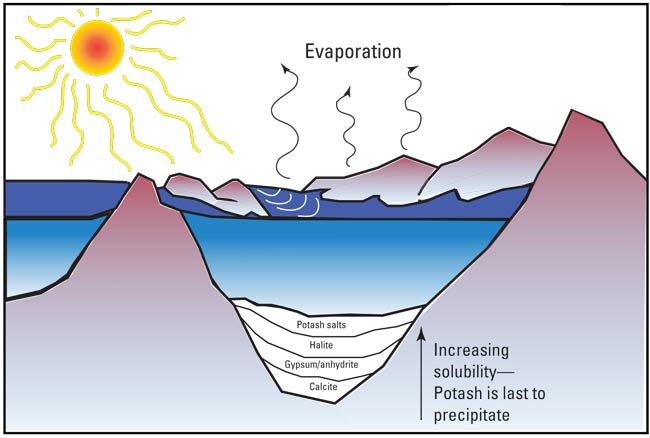
Restricted basins have only limited connectivity with the open ocean, and they can become hypersaline due to evaporation. During periods of higher sea level, seawater in the Paradox Basin had normal salinity as water flowed freely between it and the surrounding seas. Typical sedimentary rocks like limestone and shale were deposited during these times. When the sea level was lower, likely during periods of glaciation, the Paradox Basin was cut off from the larger ocean. Then, as evaporation progressed, salinity increased and concentrations of calcium, sodium, potassium and other ions increased to the point where they became supersaturated and began to precipitate. Minerals precipitate from seawater in order based on how soluble they are. The least soluble minerals like calcite, precipitate first. Then gypsum and anhydrate, both forms of calcium sulfate, precipitate. Halite precipitates next if ion concentrations continue to increase, and finally potash. By the time potash deposits form, potassium concentrations are approximately 90 times that of normal seawater.
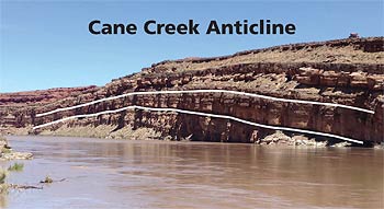 |
| The Cane Creek anticline. The Honaker Trail Formation, which is located above the Paradox Formation, is exposed at the surface along the Colorado River at Potash. |
The Paradox Formation contains at least 29 sedimentary cycles where normal marine rocks like limestone and shale transition to evaporate deposits after sea level had dropped, and the Paradox Basin was cut off from open water. Potash is not present in every sedimentary cycle because incursions of fresh seawater sometimes occurred before salinity increased enough for sylvite to precipitate. The next cycle began when sea level increased enough to flood the Paradox Basin again.
In many areas in southern Utah, the Paradox Formation is only found beneath the earth’s surface buried beneath younger rock layers like the Moenkopi Formation or Entrada Sandstone. Typically, the Paradox Formation is only exposed at the surface or is present at shallow depths along the axis of anticlines, which are upwarps or concave folds in the rock layers. The Intrepid Potash mine actually sits on top of one of these folds,
 |
| Core samples from the Cane Creek #1 well, which was drilled for potash exploration in the 1950s. USGS Central Region Core Research Center Administration Photograph |
the Cane Creek anticline. Salt anticlines are a unique type of anticline found in parts of the Paradox Basin where salt thicknesses are greatest. The folding at salt
anticlines was caused by movement of the salt itself. Salt can flow plastically when under great pressure when buried by overlying sediments. Since salt is less dense than other types of rock, it flows up, doming the layers above it. The Moab-Spanish Valley is a salt anticline that collapsed after salt was dissolved by shallow groundwater. Outcrops of the Paradox Formation can be found at some salt anticlines, such as on the flank of the Moab-Spanish Valley. Salt and potash are not present in these outcrops because the climate in southern Utah is too wet.
Overall, thousands of feet of salt were deposited in the Paradox Basin, although original thicknesses are difficult to determine given the flowage of salt into and out of some areas. Potash is only a minor constituent in the Paradox Formation, but the economic value of this commodity means that it has an outsized importance within the Paradox’s geologic history.
Next month, Geology Happenings will explore the geology of potash in further detail, along with an overview of how Intrepid Potash takes advantage of the high solubility of sylvite to produce this important fertilizer. And understanding this geologic backstory is helpful in understanding the current mineral production at Potash.
 |
| Core samples from the Cane Creek #1 well, which was drilled for potash exploration in the 1950s. USGS Central Region Core Research Center Administration Photograph. |