 |
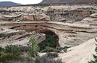
| The Cedar Mesa Sandstone in Natural Bridges National Monument. Photo by James St. John |
At first glance, the Cedar Mesa Sandstone is just like other prominent sandstone layers (formations to geologists) found in canyon country. Like the Wingate, Navajo, and the Entrada sandstones, the Cedar Mesa is eolian in origin, meaning it was deposited by wind. In southeastern Utah, eolian sandstones dominate the scenery. They make up the cliffs towering above Moab and rimming most mesas and buttes in the area. Eolian sandstones are also sculpted into rock domes and spires, as well as natural bridges and arches.
While the Cedar Mesa Sandstone shares many features with other eolian units, it has its own distinctive character and geologic story. It also makes up some of the most iconic scenery found on the Colorado Plateau from the Needles of Canyonlands National Park to white sandstones in Natural Bridges National Monument.
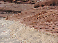 |
| Eolian crossbedding in red and white Cedar Mesa Sandstone in the Needles District of Canyonlands National Park. |
The Cedar Mesa Sandstone was deposited in and along the margins of a massive sand dune system, or erg (“sand sea”), approximately 280 million years ago. The heart of the Cedar Mesa dunefield was in the Cedar Mesa area, in the general vicinity of Natural Bridges, where the sandstone attains a thickness of more than 1,200 feet. The Cedar Mesa is about 650 feet thick in the Needles District, which was closer to the northern margin of the field. It pinches out (or thins to a feather edge and then to no thickness whatsoever) just north of the Needles. It is not present underneath the Island or the Sky or Lockhart Basin, much less further north near Moab.
By studying the Cedar Mesa (along with rocks of the same age) across a large regional area, geologists are able to reconstruct the paleogeography at its time of deposition. When the Cedar Mesa dune system was active, the Ancestral Rocky Mountains were present in western Colorado. Rivers flowing from them dumped red sediments in the Moab area and further south towards the dunefield. Ocean waters lapped to the west, and an arid mudflat was present near where the Four Corners now meet.
Like other eolian sandstones, the Cedar Mesa is characterized by crossbedding, which are inclined layers formed by moving dunes or ripples. As a general rule, eolian crossbedding is at a much steeper angle and at a larger scale than crossbedding formed by rivers or ocean currents. The prevalence of large, steep crossbedding in the Cedar Mesa Sandstone provides some of the most direct evidence that these sands were deposited by blowing winds.
Further study of the crossbedding and other aspects in the Cedar Mesa has allowed geologists to infer detailed information about the ancient erg. For example, the direction that the crossbedding dips (or slopes downward) indicates that the prevailing wind direction was to the southeast, and that the source of the sand was the shoreline to the west.
Careful examination of outcrops of the Cedar Mesa in three dimensions (such as the Needles District’s sculpted landscape allows) has led to the identification of the type, shape and size of dunes and the overall topography of the dunefield. Features indicating sand sheets (flat, gently undulating sand surfaces), barchan (crescent-shaped) dunes, and even transverse (linear) draa (megadunes) have been described. Evidence of interdune ponds and the root systems of vegetation growing in areas between the dunes has also been recorded.
In addition to angled crossbedding, the Cedar Mesa contains prominent horizontal layers that are one of its most obvious features. Many of these horizontal layers are flood surfaces, or erosional surfaces that formed during short
breaks in eolian deposition due to fluvial (river) flooding of the sand sea.
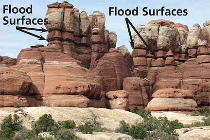 |
| With the exception of the labeled flood surfaces and a few of the other horizontal laminations, the light red and white sandstones in this photo are eolian in origin. |
Flood surfaces are usually thin dark red layers that are softer and less resistant to erosion than the eolian layers, forming overhangs and recesses in the cliffs. Other horizontal layers (super surfaces) are also present indicating longer periods of erosion.
Even though the Needles District area is near the northern boundary of the dunefield, the Cedar Mesa Sandstone in Canyonlands consists mostly of eolian beds. The eolian sandstones are generally white to light red in color with the colors resulting from bleaching by fluids that moved through the sediments as they turned into stone. However, the more mud-rich flood surfaces retained their dark red color because they aren’t as porous.
It is easy to imagine that a past environment such as an erg was monolithic, e.g., “just sand,” without any variation within it nor signs of life. But detailed exploration of the Cedar Mesa Sandstone can reveal details of ancient topography and environments as varied as those encountered in modern landscapes like Great Sand Dunes in Colorado or one of the many dune system found along the coast.
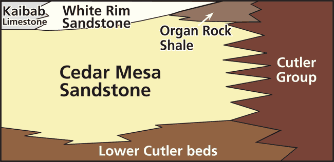 |
| The Cedar Mesa Sandstone is part of a larger part of sediments called the Cutler Group. Closer to the Ancestral Rocky Mountains (on the right side of the diagram), the Cutler Group can’t be broken up into individual formations, but further away, such as where Canyonlands National Park is now, the Cutler can be divided into different formations, including Cedar Mesa Sandstone present in the Needles District, and the White Rim Sandstone below the Island in the Sky. |