GEOLOGY HAPPENINGS November 2020 |
||||||||
| Moab’s Geology: Not Always on the Level, Major Types of Geologic Foldsby Allyson Mathis | ||||||||
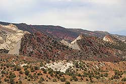
The geology of the Moab area is largely characterized by flat-lying sedimentary rocks. Despite the predominance of horizontal rock layers, there are places where the rocks have been tilted or folded. Sometimes the tilt (dip) is subtle, being only a few degrees from horizontal. But in other areas, the dip is dramatic, even approaching vertical. These dips and folds are important parts of southeastern Utah’s geologic story as they are integral to some of canyon country’s most striking landscapes.
According to the Law of Original Horizontality, sedimentary rocks are deposited in flat layers. Most sediments are deposited at or near sea level. For example, near Moab, the Entrada Sandstone formed in coastal sand dunes. After burial by additional sediments and lithification (the processes that turn sediment into stone), the Entrada and other rock layers were uplifted and then eroded to form the landscapes that we see today near Moab.
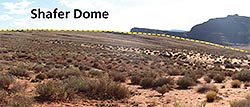
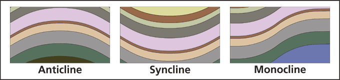
Geologists classify folds on the basis of their shape. The three major types of folds are anticlines, synclines, and monoclines, with the root “-cline” coming from the Latin word clinare “to bend or slope.” Anticlines are folds that are convex upwards (or concave downwards). To use a silly analogy, an anticline can be visualized as being formed by rock layers draping over a massive hippopotamus rising from the geologic depths. Synclines are the opposite, being convex downwards, as if bending underneath the weight of a geologic hippo above the rock layers. An anticline that is roughly circular or oval in shape (versus being elongated) is termed a dome, whereas a basin is a circular or oval syncline.
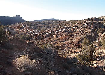
A monocline can be thought of as half of a fold, as it is a single steeply-dipping limb in an area of otherwise gentle dips. Monoclines typically are bounded on one side by an anticline and a syncline on the other. Anticlines and synclines make characteristic patterns as seen on the ground, although topography does not always follow the structural bend of the rock layers. Actually, the opposite happens often enough that geologists have a term for it: inverted topography to describe a valley that sits over an anticline or a highland situated over a syncline.
Folds are more than just structures that geologists study. They impact human life in many ways. For example, oil and gas deposits are found in anticlines, monoclines can create barriers to travel, and synclines can host important aquifers. In southeastern Utah, large anticlines are inherent to iconic places such as the San Rafael Swell and the Circle Cliffs anticline. Even Canyonlands National Park is in a large anticline, although the tilting there is minimal. The park is on the northern end of the Monument Uplift that extends north from Arizona. Comb Ridge and the Waterpocket Fold are two prominent monoclines in southeastern Utah. Both are on the eastern limb of large anticlines, and their steep ridges have presented challenges to road builders and travelers. Comb Ridge is just west of Bluff on the flank of the Monument Uplift. The Waterpocket Fold makes up the heart of Capitol Reef National Park. The total amount of vertical displacement across these structures is substantial. For example, rocks exposed at the surface near the Capitol Reef Visitor Center are about 6,000 feet below the Earth’s surface in the Henry Basin east of the park due to the downwarping across the fold. Here in southeastern Utah, our eyes are accustomed to following horizontal strata on mesa edges and in canyon walls. Yet becoming attuned to the warps and bends present in the rocks can enrich appreciation of canyon country. Anticlines, synclines, and monoclines are as much of Moab’s geologic heritage as the ancient geologic history recorded in the rock layers, the uranium and potash deposits, and the spectacular scenery of arches, fins, and cliffs. |
||||||||
|
||||||||
|
.jpg)