 |
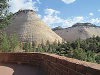
Zion National Park
NPS Photo by Caitlin Ceci |
The Navajo Sandstone is one of the most spectacular rock layers (formations to geologists) in canyon country. It is responsible for much of the superlative scenery found across southern Utah. The Navajo Sandstone is perhaps best known for being the “rock star” in Zion and Capitol Reef national parks with their soaring white- to orange-colored cliffs and domes. It is also largely responsible for Glen Canyon’s picturesque canyon walls. Rainbow Bridge is also made of Navajo Sandstone.
The Navajo is also prominently exposed along Highway 12 between Boulder and Escalante, making up a key element of what is considered to be one of the most scenic drives in the country. In Grand Staircase-Escalante National Monument, the Navajo makes up the White Cliffs.
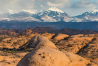
 Near Moab, the Navajo plays more of a supportive role in the area’s scenery. Or perhaps the rock layer is better viewed as is a member of an ensemble cast since so many different rock layers are integral to landscape near Moab. For example, most of the arches in Arches National Park are in the Entrada Sandstone, and the prominent cliffs at Dead Horse Point State Park and above Moab are made up the Wingate Sandstone capped by the Kayenta Formation. Yet, the Navajo is responsible for many important landmarks. On the mesa top of the Island in the Sky in Canyonlands, Mesa Arch and Aztec Butte are in the Navajo, as are the Petrified Dunes in Arches. The Slickrock Bike Trail along with the Fins and Things 4WD route at Sand Flats and Corona Arch are all in the Navajo Sandstone. Imagine what canyon country would be missing without all of these places. Near Moab, the Navajo plays more of a supportive role in the area’s scenery. Or perhaps the rock layer is better viewed as is a member of an ensemble cast since so many different rock layers are integral to landscape near Moab. For example, most of the arches in Arches National Park are in the Entrada Sandstone, and the prominent cliffs at Dead Horse Point State Park and above Moab are made up the Wingate Sandstone capped by the Kayenta Formation. Yet, the Navajo is responsible for many important landmarks. On the mesa top of the Island in the Sky in Canyonlands, Mesa Arch and Aztec Butte are in the Navajo, as are the Petrified Dunes in Arches. The Slickrock Bike Trail along with the Fins and Things 4WD route at Sand Flats and Corona Arch are all in the Navajo Sandstone. Imagine what canyon country would be missing without all of these places.
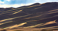 |
| Modern dunes in Great Sand Dunes National Park -
NPS photo by Patrick Myers |
While the Navajo Sandstone appropriately deserves many accolades for its contribution to southern Utah’s iconic scenery, its origin and geologic history is just as spectacular, albeit in different ways. The Navajo Sandstone was deposited in a massive sand dunefield that was, in fact, the largest dunefield in North America’s history. Approximately 185 million years ago, most of what is now the state of Utah and parts of adjacent states was covered by sand dunes. Geologists use the terms erg or sand sea to describe such dune systems. Erg comes from the Arabic word for sand dune, and sand sea describes the appearance of dunes separated by troughs that may resemble storm waves in a body of water but that have been solidified or frozen in place.
 Sand dunes are eolian in origin meaning that they are made up of grains predominately transported and deposited by the wind. Sand can be made up of any rock material (although it is usually quartz, i.e., silicon dioxide), but with specific size between 0.0625 mm to 2 mm (a mm is 0.04 inches). Eolian sandstones like the Navajo, Entrada, and Wingate are usually very fine grained as wind generally only has the ability to transport smaller particles as compared to beach or river sands transported by water. Sand dunes are eolian in origin meaning that they are made up of grains predominately transported and deposited by the wind. Sand can be made up of any rock material (although it is usually quartz, i.e., silicon dioxide), but with specific size between 0.0625 mm to 2 mm (a mm is 0.04 inches). Eolian sandstones like the Navajo, Entrada, and Wingate are usually very fine grained as wind generally only has the ability to transport smaller particles as compared to beach or river sands transported by water.
 |
| Petrified Dunes - NPS Photo by Neal Herbert |
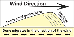
One of the primary eolian features of the Navajo Sandstone is cross bedding,
which is also called cross stratification. There are many different types of cross stratification depending on the type of dune and other factors, but the overall concept is more or less the same. As wind blows across a dune, sand is picked up on the windward side, and then is deposited on the leeward side where the wind speed drops, forming layers parallel to the dune surface.
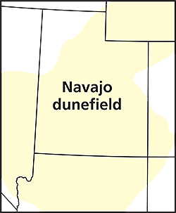
The Navajo Sandstone and its equivalents such as the Nugget Sandstone in Dinosaur National Monument in northeastern Utah are exposed today in an area of approximately 230,000 square miles. But sandstones that were deposited in the original Navajo erg have been removed by erosion in many areas. The entirety of the Navajo erg may have covered as much as 850,000 square miles in an area from southern California and north to Idaho and Wyoming. The Moab area was near the eastern margin of the dune system, which is why the Navajo Sandstone is only a few hundred feet thick here. The Navajo is thicker to the west, and is about 1,000 feet thick in Capitol Reef, and 2,000 feet thick in Zion closer to the heart of the dunefield.
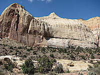 |
| Capitol Reef National Park |
The dune system into which the Navajo Sandstone was deposited was much more than a desolate expanse of sand completely devoid of life. Dinosaurs lived among the dunes, as evidenced by both bones and tracks that have been preserved as fossils. Interdune lakes likely provided oases where trees and other vegetation grew.
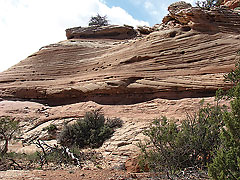 |
| Aztec Butte cross bedding |
The high desert of southern Utah is graced by sheer cliffs and bare sandstone surfaces, a landscape much different than a massive sand sea. The Navajo Sandstone serves as an important link between the geologic past and present. With the passage of geologic time, the blowing sands of an ancient erg gave rise to modern slickrock domes.
|