GEOLOGY HAPPENINGS July 2021 |
||||||
| More Beautiful Then a Sore Thumb: Southeastern Utah's Laccolithic Mountain Ranges by Allyson Mathis |
||||||
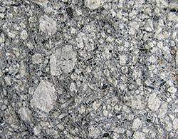
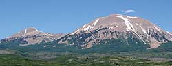
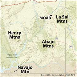
Three isolated mountain ranges, the La Sals, the Abajos, and the Henrys, stand over southeastern Utah, a striking contrast to the red rock deserts below them. In fact, these mountains are in so different to the rest of the Colorado Plateau landscape that they stick out like a proverbial sore thumb. These mountains are so distinct from canyon country—characterized by striated rock walls and bare sandstone domes—because their geology is different. To many people, the most obvious divergence between the mountains and the desert is the vegetation. Sage, blackbrush, prickly pear cactus, and sparse desert grasses are found in the dry canyons and desert flats. During the summer, the higher elevations feature cooler temperature and riots of lush green vegetation including aspen groves and pine forests. But the bedrock that makes up the highest peaks in these mountains is also completely different. Instead of the red sandstones and mudstones found in the canyons, the mountains are made of crystalline rocks showcasing white and black crystals. These crystalline rocks are igneous in origin and they hold clues as to how these isolated mountain ranges were formed. Igneous (“fire-born”) rocks are formed by the solidification of magma (molten rock). Intrusive rocks are crystallized within the Earth, in contrast to volcanic rocks that are erupted onto the surface or into the atmosphere.
The igneous rocks in the La Sals and the other isolated ranges almost appear to be intermediate between typical intrusive rocks and volcanics: they have large crystals like intrusive rocks, but also a very fine-grained groundmass as in volcanic rocks. And in some ways, they are close to being intermediate as the magma they crystallized from was intruded very close to the surface. The igneous rocks in these mountains solidified at depths between one and four miles. The larger crystals grew while the magma resided at deeper levels of the crust, and the groundmass formed from rapid cooling once it was near the surface. These intrusions were so shallow that it is possible some volcanic activity may have accompanied their formation, but any evidence of that hypothetical volcanic activity has been eroded away. 
The La Sal, Abajo, and Henry Mountains, as well as other isolated peaks in the Four Corners region including Navajo Mountain, Sleeping Ute Mountain, and, the Carrizo Mountains are laccoliths. The term describes their shape and is derived from the Greek words for “pond” and “stone.” Laccoliths are domed or mushroom-shaped intrusions with flat bottoms and rounded tops. Laccoliths form when magma is injected between flat layers of sedimentary rock and force the overlying layers to bulge above it. The laccolithic mountain ranges in southeastern Utah and the larger Four Corners region were emplaced at the same time as the Ignimbrite flareup, a period of intense volcanic activity between about 36 and 18 million years ago that stretched from Nevada, across Utah, and into southwest Colorado. Ignimbrites are a type of volcanic rock that is made up of volcanic ash and rock fragments erupted during extremely explosive volcanic eruptions. During the Ignimbrite flareup, supervolcanoes erupted great quantities of volcanic ash that formed pyroclastic flows. Pyroclastic flows are fast-moving density currents of ash, other volcanic ejecta, and superheated volcanic gases that can travel many tens of miles from volcanoes and obliterate everything in their paths.
None of the supervolcanoes that erupted during the Ignimbrite flareup were located in southeastern Utah. With the exception of the laccoliths that formed the Henry, La Sal and Abajo mountains, where only small volumes of magma were intruded, the period of intense magmatism during this time period was located to the east and west of the Colorado Plateau. This east-west gap in volcanic activity may be because of the thick continental crust underneath the Colorado Plateau. All geologic landscapes hold evidence of how they formed. Rocks contain features that reveal how the environments in which they were deposited (in the case of sedimentary rocks), or how they were crystallized (for igneous rocks). Careful observation of the shape of the igneous bodies exposed in the highest elevations of the La Sals and other ranges, as well as the way the sedimentary rocks around them have been warped and folded around them, provide information about the dynamics of how they were intruded. Analyses of minerals found in the igneous rocks have revealed when and the depths at which they were crystallized. While a simple glance of the alpine peaks of these isolated range suggests that their story must be different than that of the canyons and cliffs below them, careful geologic investigation has revealed the details of what, when, and how, as well as their relationship to geologic events in the larger region. |
||||||
|