 |
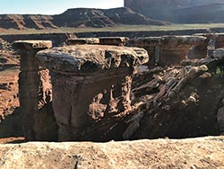
| The White Rim Sandstone capping the Organ Rock Formation |
Sandstone is a fact of life in Canyon Country. True, other types of rock are found near Moab. A variety of other sedimentary rocks, including siltstone, mudstone, and some limestone, are present in some of the region’s rock layers (formations to geologists), and the La Sal, Abajo, and Henry mountain ranges are cored by igneous rocks that crystallized from molten material (magma). But sandstone is so much at the heart of this landscape that the nearby national park could arguably be known as Sandstonelands versus Canyonlands.
Out of the 15 or so most prominent rock layers exposed in southeastern Utah, six are sandstones. Quite simply, sandstone is a rock made of sand grains that have been cemented together. Specifically, this region’s prominent sandstones are eolian sandstones, meaning that the sand grains in them were transported and deposited by the wind in vast sand dune fields knows as ergs (sand seas).
The White Rim, Cedar Mesa, Wingate, Navajo, and Entrada sandstones were all deposited in eolian systems as was the Moab Member of the Curtis Formation. (A member is a subdivision of a formation).
 Eolian sandstones are made of very fine sand grains, versus coarser sand grains that can be transported by flowing water. Most of the sand grains in eolian deposits are made up quartz, which is a very durable mineral that doesn’t break down into clays like some others. Eolian grains have been rounded and even frosted by being bounced along the surface of dunes by blowing winds. Eolian sandstones are made of very fine sand grains, versus coarser sand grains that can be transported by flowing water. Most of the sand grains in eolian deposits are made up quartz, which is a very durable mineral that doesn’t break down into clays like some others. Eolian grains have been rounded and even frosted by being bounced along the surface of dunes by blowing winds.
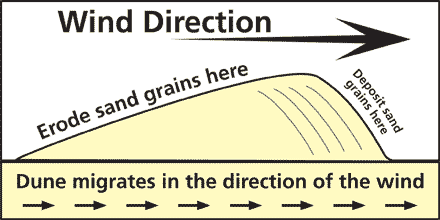
One of the most noticeable characteristics of eolian sandstones is the presence of cross bedding. Cross bedding is a type of layering within a layer (bed) that is at an angle to the main bedding. It forms as wind picks up sand on the windward side of a dune and transports it to the leeward side, where it is deposited, forming layers parallel to the moving dune surfaces.
While the six eolian sandstone rock layers in Utah share similarities in rock type, size and type of sand grains, and erg depositional environments, each is unique in terms of time and place. Two of the layers (the Cedar Mesa and the White Rim sandstones) were formed during the Permian Period before the Age of the Dinosaurs, and the others formed during the Mesozoic when dinosaurs walked the earth. In fact, dinosaur tracks have been documented in at least two eolian layers (the Navajo Sandstone and the Moab Member).
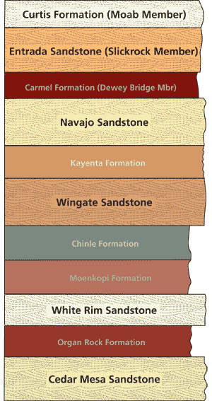 |
| Rock layers showing cross-bedding symbols are eolian in origin, and layers without symbols were deposited in other types of environments. |
Although each of the eolian layers were deposited in sand dune fields, there were large differences in the sizes of these ergs, and where they were located. The Navajo was deposited in the largest sand dune system in North America’s history; one that covered an area of approximately 230,000 square miles in most of what is now the state of Utah and parts of adjacent states. On the other hand, the Moab Member erg was only present in a small region centered around Moab with an area of a little more than 1,000 square miles.
The Cedar Mesa Sandstone was only present in far southeastern Utah (extending north to about the location of the Needles District of Canyonlands National Park), while a short time later, the White Rim erg was located a little further north of that. Neither of these two units are found in the immediate vicinity of Moab.
The eolian sandstones of southeastern Utah range in color from white to a yellowish hue to orange and brown. The quartz sand grains themselves are white in color as is evident in the White Rim, Navajo, and Moab Member sandstones. The colors of the other layers come from miniscule amounts of iron oxide (rust-like) minerals that coat the sand grains. The ancient sand dunes themselves likely had a pink to orange color from the iron oxide coatings on the grains, but these coatings were later bleached by fluids circulating in the subsurface at some point after deposition.
All of the eolian layers form expanses of slickrock (smooth exposed rock surfaces), except for the Wingate Sandstone. One of the main reasons that the Wingate Sandstone forms sheer cliffs instead is because it overlies softer rock layers that more readily erode to undercut it and cause rock falls.
Since southeastern Utah’s eolian sandstones are a defining feature (if not the defining feature) of canyon country, getting to know them and ultimately learning to tell them apart can add to the appreciation and enjoyment of this landscape. While similar, each of these sandstones contribute distinctive features to the land: the slickrock spires of the Cedar Mesa, the broad bench of the White Rim, the soaring cliffs of the Wingate, the rounded rock domes of the Navajo, the especially smooth and steep slickrock slopes of the Entrada, and its sheer white cap of the Moab Member.
Perhaps one of the life lessons that resides within Moab’s eolian sandstones is to recognize the beauty that can be found in something that is made of a material as simple as sand.
 |
 |
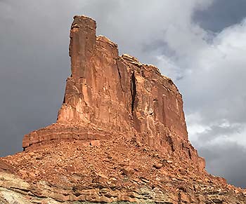 |
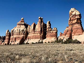
| The Cedar Mesa Sandstone |
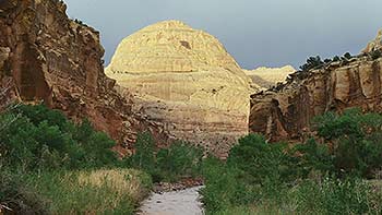
The Navajo Sandstone in Capitol Reef National Park. NPS photo. |
Vertical walls of the Wingate Sandstone with rock fall debris at the base of the cliffs |
|
 A self-described “rock nerd,” Allyson Mathis is a geologist, informal geoscience educator and science writer living in Moab.