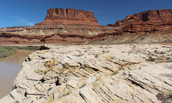
White Rim Sandstone along the Green River in Canyonlands
National Park.
Nearly every bit of public information about the geology of the canyon country near Moab and in the neighboring parks (Arches, Canyonlands, Dead Horse Point, and Utahraptor) includes descriptions of rock layers that are identified by name: Chinle Formation, Wingate Sandstone, Navajo Sandstone, Entrada Sandstone, and Morrison Formation to name a few. If you know the geography of the Southwest, particularly of the Colorado Plateau (the Four Corners region around where Utah, Colorado, New Mexico, and Arizona join), the linkages to place names are obvious: Chinle, Arizona; Fort Wingate, New Mexico; and the Navajo Nation (reservation). Some layers reflect places that are less known, like Entrada Point in the San Rafael Swell west of Moab, or are further afield like Morrison, on the outskirts of Denver, Colorado.
As should not be surprising given that geology is a scientific endeavor, a set of guidelines dictate the naming of rock units in the field of stratigraphy (the study of strata [e.g., rock layers]). The North American Stratigraphic Code provides the standards for naming rock units, like the codes that define the systems of scientific binomial nomenclature for plants and animals.
One difference is that in geology there are no separate common or scientific names; a single name defines each rock unit. Geologic names consist of two parts: the first reflects the place where the rock layer was scientifically described, and the second part either gives the main rock type (lithology; e.g., sandstone, limestone, shale, etc.) or uses a term like group, formation, or member to give stratigraphic rank, which is somewhat akin to the biological ranking system of genus, species, and subspecies.
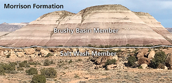
The Brushy Basin Member overlying the Salt Wash Member of the Morrison Formation near the Salt Wash type section near the
Blue Hills.
The fundamental unit in stratigraphy is a formation (like a species is in biology). Formations are commonly known as rock layers. At least here in canyon country where there is nearly 100% exposure of bedrock and there are rock layers with distinctive rock types, color, and other characteristics, formations can be widely recognized by hikers and travelers. Different layers form different types of landforms (cliffs or slopes), contain different suites of fossils (like the dinosaurs of the Morrison Formation), or are likely to host natural arches (like the Entrada Sandstone).
In biology, a type specimen (or holotype) for each species (or subspecies) is kept in a museum facility to be a reference for study by other researchers. Geologists use a similar reference system for rock layers. However, since formations consist of sequences of rocks that may be hundreds of feet thick, there is no way to house reference specimens in a museum drawer.
Instead, geologists define type sections (also known as stratotypes) for each named rock unit. These are specific exposures of a rock layer that was studied when it was first scientifically defined. Per the stratigraphic code, a rock layer named based on the geographic location of its type section. Once a type section is defined, it never changes, and serves as a permanent reference for all future study.
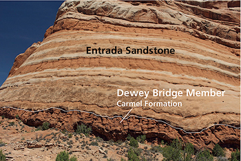
Outcrop of the Dewey Bridge Member of the Carmel Formation near the Dewey Bridge type section near the Dolores River. The Dewey Bridge Member is characterized by contorted bedding.
Sometimes rock units, particularly ones that were designated in the pioneering days of geologic exploration, do not have specific type sections identified, but are defined on a broader basis. For example, the Navajo Sandstone, the rock layer that makes up Mesa Arch in Canyonlands National Park and the Petrified Dunes in Arches, was named for exposures on the Navajo Nation, but no exact type section exists.
The lexicon of geologic nomenclature for rock layers found near Moab reflects the history of scientific research in Southwest. Many units were named for places in northern Arizona and New Mexico due to the work of early geologists in those areas.
Many other rock layers were named for exposures in southeastern Utah. For example, the Cedar Mesa Sandstone of Natural Bridges National Monument is named for the eponymous tableland of the Bears Ears region, and the White Rim Sandstone for the distinctive white bench in Canyonlands between the Green and Colorado Rivers. The Cedar Mountain Formation, which was not described until 1944, was named for Cedar Mountain, located northwest of Moab and southwest of Price, Utah.
Members (subdivisions of formations) are subject to the same naming conventions, and type sections for several members are found in southeastern Utah, including those for the Morrison Formation.
The presence of geologic type sections located throughout canyon country is another way that this area is a vast, grand geologic museum. The rocks exposed near Moab are part of the scientific record of our planet with its changing landscapes, climates, and history of life.
The type section of the Cedar Mountain Formation.
Photo by Kenneth Carpenter, CC BY-SA 4.0
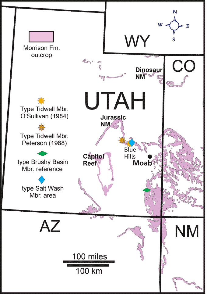
Map showing the outcrop area of the Morrison Formation and location of type sections for three of its members. Two researchers designated type sections of the Tidwell Member (named for Tidwell Bottoms on the San Rafael River). Modified from Figure 1 in The Morrison Formation and its Bounding Strata on the Western Side of the Blanding Basin, San Juan County, Utah by James Kirkland et al. Used with permission.
A self-described “rock nerd,” Allyson Mathis is a geologist, informal geoscience educator and science writer living in Moab.
To learn more about Moab’s geology, visit the Geology Happenings archive online at https://www.moabhappenings.com/Archives/000archiveindex.htm#geology
-sharpened.jpg)
 A self-described “rock nerd,” Allyson Mathis is a geologist, informal geoscience educator and science writer living in Moab.