If any interval of the geologic time scale is known to the general public or within pop culture, it is the Jurassic because of the famed Steven Spielberg movie Jurassic Park. Like all periods in the Geologic Time Scale, the Jurassic was named for a region where rocks bearing certain fossils of a specific age were first described; in this case, the Jura Mountains of the France-Switzerland border. In the geologic time scale, periods are major subdivisions that span tens of millions of years and that are characterized by rocks with distinctive fossils.
Like most movies, Jurassic Park took some artistic licenses and did not adhere to strict scientific facts. It is true that dinosaurs were particularly abundant and diverse in the Jurassic, but many of dinosaurs depicted in the movie had fictional characteristics and most of them more closely resembled dinosaurs from a later geologic period, the Cretaceous.
The Moab area is a better place to learn about what the Earth was like during the actual Jurassic than the scenes depicted in the movie. A huge proportion of the rocks exposed in the canyon country surrounding Moab were deposited during the Jurassic between about 201.4 and 145 million years ago. These rocks contain evidence of ancient sand dunes, river systems and fertile floodplains, and yes, of dinosaurs. Jurassic-aged rocks are also found in other parts of Utah; notably in Jurassic and Dinosaur National Monuments. But overall, the Jurassic rock record in the Moab area is particularly significant and scenic.
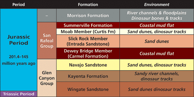
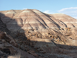
Three main packages of Jurassic rocks are found in southeastern Utah. From oldest to youngest, they are the Glen Canyon Group, the San Rafael Group, and the Morrison Formation. Groups consist of multiple rock layers (formations to geologists) that are related to one another in their geologic history.
The Glen Canyon Group contains some of the most scenic rock layers in all of canyon country. The oldest layer (which actually began to be deposited in the Triassic Period, prior to the start of the Jurassic), the Wingate Sandstone, combines with the overlying Kayenta Formation to hold up the red rock cliffs along the Colorado River and above Moab and in Canyonlands National Park. The Wingate is also the oldest of four sandstone layers that were deposited in sand dune systems during the Jurassic in what is now southeastern Utah. The climate in the Jurassic was warmer than it is today, and the Utah area experienced either arid or semiarid conditions, although other parts of the globe had more humid climates.
The Navajo Sandstone, the uppermost layer of the Glen Canyon Group, reveals the largest sand dune system in North America’s history. It covered an area of approximately 230,000 square miles. Rocks deposited in these sand dunes are seen not only in Canyonlands and Arches National Parks near Moab, but also in Capitol Reef and Zion as well as in Glen Canyon National Recreation Area.
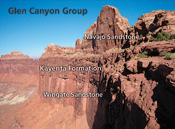
The San Rafael Group is named for rocks exposed in the San Rafael Swell area west of Moab. These rocks have distinctive facies (different rock types) or members (subdivisions of a rock layer) here in southeastern Utah and they make up much of the iconic scenery of Arches National Park. The Dewey Bridge Member of the Carmel Formation and the Slick Rock Member of the Entrada Sandstone combine to form most of the arches and windows found in the park. Additionally, the rocks of the San Rafael Group are more colorful here in southeastern Utah, featuring dark reds, vibrant oranges, and stark whites.
During the time when San Rafael Group was deposited a narrow shallow seaway extended from the north through central Utah. Unlike the marine and tidal flat facies deposited to the west, sediments were deposited on land in southeastern Utah: in coastal sand dune fields for the Slick Rock Member of the Entrada Sandstone and the Moab Member of the Curtis Formation, and in mud flats for the Dewey Bridge Member of the Carmel Formation and the Summerville Formation.
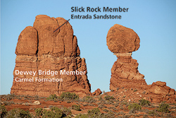
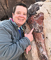
The Morrison Formation is the main dinosaur-bearing rock layer exposed in southeastern Utah from the Jurassic. Other Jurassic rock layers in the Moab area do contain dinosaur fossils, but mostly their footprints and trackways, such as at the Dinosaur Stomping Ground, which is in the Moab Member of the Curtis Formation. The Morrison contains both bone and track fossils, with some bone fossils being viewable along the Mill Canyon Dinosaur Trail.
The Morrison Formation records the lushest environment of any of the Jurassic rock layers found near Moab. The climate was still semi-arid, but rivers flowed into eastern Utah from highlands to the west, and lakes were plentiful due to a high water table. Dinosaurs, reptiles, and even tiny mammals were also abundant, living along the rivers and on their floodplains. Allosaurus, Camarasaurus, Apatosaurus, Stegosaurus and other dinosaurs would have inhabited the basin where the Morrison Formation was deposited.
 The Glen Canyon Group in Canyonlands National Park.
 Two formations in the San Rafael Group in Arches National Park.
 An outcrop of the Morrison Formation. The colorful bands are formed by ancient soil horizons.
|
 A self-described “rock nerd,” Allyson Mathis is a geologist, informal geoscience educator and science writer living in Moab.