|
|
Motorized HAPPENINGS May 2019
|
| Seven Mile Rim |
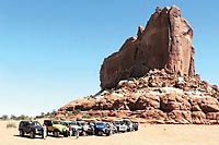 The Sevenmile Rim trail leaves Highway 191 just north of Highway 313, about 11 miles north of town. It passes the old Cotter uranium mine and switches back to reach the cliff rim above the mine and Highway 191. The intense mining activity left a maze of core-drilling roads on the mesa top, and the trail seeks the most interesting of these. At the southern end of the rim it turns west to parallel UT 313. Along the way, Uranium Arch is visited. The trail joins other roads in the vicinity of Merrimac Butte and Monitor Butte before tucking up near Big Mesa. It passes near Determination Towers before using Tusher Pass to dip into Tusher Wash and the interesting environs beyond. Approximate mileages: 51 total, 21 off highway. The Sevenmile Rim trail leaves Highway 191 just north of Highway 313, about 11 miles north of town. It passes the old Cotter uranium mine and switches back to reach the cliff rim above the mine and Highway 191. The intense mining activity left a maze of core-drilling roads on the mesa top, and the trail seeks the most interesting of these. At the southern end of the rim it turns west to parallel UT 313. Along the way, Uranium Arch is visited. The trail joins other roads in the vicinity of Merrimac Butte and Monitor Butte before tucking up near Big Mesa. It passes near Determination Towers before using Tusher Pass to dip into Tusher Wash and the interesting environs beyond. Approximate mileages: 51 total, 21 off highway.
Scenery
The trail route is near the Moab Fault, a geological fracture that left the trademark rocks of Canyonlands standing higher than the surrounding colorful Morrison formation. Entrada Sandstone cliffs are constantly in view. The rim views include Sevenmile Canyon, the Arches National Park area, and the Book Cliffs to the north.
Surface
There is considerable two-track dirt trail, lots of slickrock, some sandy sections, a sandy washbottom, and a sandy hill near the end.
Trail Details
The cliff rim portions are mainly scenic. Uranium Arch can be walked across. The south side of Merrimac Butte has exciting sidehill slickrock driving and is near Wipe Out Hill, which can be visited if there is time. The last part of the trail, if used, runs the reverse direction of the Wipe Out Hill Trail in the Tusher Canyon system, and finds easy hills of that trail to be hard, and vice versa.
|
Trail Difficulty Ratings are for Moab area roads in dry conditions. The effects of snow or rain varies greatly depending upon the altitude of the roads and the type of soil.
NOTE: The Red Rock 4 Wheelers Club attempts to keep the trail ratings current. However weather and usage constantly alters the routes. Heavy but localized rains can change Kane Creek from a moderate trail to impassable in an afternoon. It is always wise to obtain the most up-to-date information prior to departing for a trip, and be prepared. Remember, turning back is usually an option as well.
For more information see the Red Rock 4-Wheeler website, www.rr4w.com, where the entire Easter Jeep Safari magazine is online. |
|
 Trail consisting of loose rock, dirt, and sand with some slickrock surfaces. Some erosion; washes, gulches and rock steps no higher than 18”. Tall tires(33” plus) and limited slip would be a plus. 4WD is required. Enhanced suspension travel and good ground clearance are helpful. Good driving skills a plus.. |
|
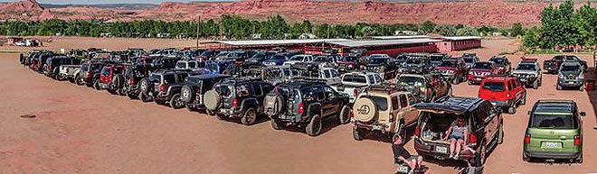
| Gone Moab April 30 - May 4 |
The Gathering of Nissan Enthusiast in Moab, UT, or goneMOAB as we like to call it, is the premier Nissan-oriented off-roading event in the country. This is our 18th year of the event and we’ve grown to about 130 vehicles and over 200 attendees. The event itself focuses on responsible off-roading in the Moab area, letting everyone enjoy the incredible scenery, fun trails, and general camaraderie that comes with our community. This volunteer-run event includes a meet and greet event, 3 provided meals, a raffle night, and up to 5 days of guided trails - ranging from easy to difficult. We welcome people of all ages, families, and skill levels - our trail selection will support all of the above. For those of you who might not own a Nissan, no worries - we welcome all vehicle types as long as they’re 4WD.
Please check us out at goneMOAB.com and get all of the details - it’s still not too late to register!
|
|
|
|
|
|
|
© 2002-2026 Moab Happenings. All rights
reserved.
Reproduction of information contained in this site is
expressly prohibited.
|
|