|
|
Motorized HAPPENINGS September 2019
|
| 3-D |
The 3-D Trail tours the vicinity of colorful Hidden Canyon and Brink Spring, northwest of Moab. It visits the canyon bottom and canyon rim, and, finally, a higher overlook of the area (hence the name 3-D). A few of the hills have been known to challenge stock vehicles, but most of the tour is pleasant, scenic, family four-wheeling. Approximate mileages: 59 total, 28 off highway.
Please note: the BLM depiction of the trail on the map below(and on their website) does not show the first 1/3 of the route used at Easter Jeep Safari and Labor Day. 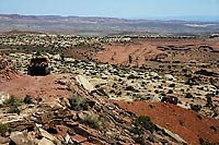
Scenery
This canyon country is unlike the Moab Valley with its sheer Wingate Sandstone rimmed cliffs; 3-D visits canyons that are a few hundred feet deep in the smooth, red-and-white layers of Entrada Sandstone, and the slickrock areas are made up of the white layer that caps the Entrada. Vistas are to the north toward the Book Cliffs.
Surface
There are some two-track dirt sections, a little slickrock, a sandy and maybe wet wash bottom, and some rock/dirt mixtures with a few ledges.
Trail Details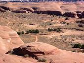
Not far from the beginning is “Airport View Hill” where a few stock vehicles with highway tire pressure may have to try more than once. Hidden Canyon bottom is very sandy but usually not difficult. The climb out of the upper canyon first encounters “The Wall” which looks like a wall to the uninitiated but is usually climbed easily by stock vehicles. Just past this is “Mean Hill’ which climbs about 200 feet in two steep sections. The first section starts with a shelf followed by a loose red dirt hill. The final climb looks worse than it is because it is on a “hogback” with a dropoff on both sides.
Length: 59 total, 28 off highway
Min Tire Size: 33+ inches
Winch: No
Front Locker: No
Rear Locker: No
|
Trail Difficulty Ratings are for Moab area roads in dry conditions. The effects of snow or rain varies greatly depending upon the altitude of the roads and the type of soil.
NOTE: The Red Rock 4 Wheelers Club attempts to keep the trail ratings current. However weather and usage constantly alters the routes. Heavy but localized rains can change Kane Creek from a moderate trail to impassable in an afternoon. It is always wise to obtain the most up-to-date information prior to departing for a trip, and be prepared. Remember, turning back is usually an option as well.
For more information see the Red Rock 4-Wheeler website, www.rr4w.com, where the entire Easter Jeep Safari magazine is online. |
|
 Trail consisting of loose rock, dirt, and sand with some slickrock surfaces. Some erosion; washes, gulches and rock steps no higher than 18”. Tall tires(33” plus) and limited slip would be a plus. 4WD is required. Enhanced suspension travel and good ground clearance are helpful. Good driving skills a plus. |
|
| |
Responsible Recreation
Red Rock 4-Wheelers, Inc.
www.rr4w.com
435-259-rock |
 Each year we lose a few more roads/trails. Closed to us forever! It’s a horrible thought, but reality! Take a minute and think about what it would mean to you to have your favorite trail closed. One of the best ways to fight this is to practice responsible Each year we lose a few more roads/trails. Closed to us forever! It’s a horrible thought, but reality! Take a minute and think about what it would mean to you to have your favorite trail closed. One of the best ways to fight this is to practice responsible
4-wheeling.
Stay on the trail. Don’t be tempted to try a new route or obstacle. Someone will follow your tracks and soon we’ll have another unauthorized road. Go over the bumps and mud, not around them. That’s what 4-wheeling is all about.
Pack out what you pack in. If you see litter on the trail, pick it up and take it out with you. Most of all, take care of and respect this land that we love to play on.
Responsible 4-Wheeling will make a difference. Please join with the Red Rock 4-Wheelers and practice responsible
4-wheeling every day. Let’s show them that we care.
|
|
|
|
|
|
|
© 2002-2026 Moab Happenings. All rights
reserved.
Reproduction of information contained in this site is
expressly prohibited.
|
|