If you visit Arches National Park during the busy tourist season, you’ll inevitably have a moment where you ask yourself if there’s anywhere you can go without feeling like you’re on a hiker highway at rush hour. The surprising answer is yes, there is.
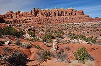 Accessible only via dirt roads and biking trails, Klondike Bluffs is located in the remote northwestern corner of Arches National Park. Even though Klondike Bluffs is only about eight miles from the main park road, you’ll feel like you’re worlds away from the rest of Arches National Park—and in many ways, you are. So be prepared and carry more water than you think you’ll need, especially in the summer. Accessible only via dirt roads and biking trails, Klondike Bluffs is located in the remote northwestern corner of Arches National Park. Even though Klondike Bluffs is only about eight miles from the main park road, you’ll feel like you’re worlds away from the rest of Arches National Park—and in many ways, you are. So be prepared and carry more water than you think you’ll need, especially in the summer.
At 43 feet high and 92 feet wide, Tower Arch is the crown jewel of Klondike Bluffs—and the reason most people venture out to this isolated district of the park. The first section of the trail requires a steep climb up the rock wall, and you’ll have to do some minor scrambling here. But once you’re at the top it’s relatively easy walking through open desert. As you cross the valley, following rock cairns for much of the way, you’ll be surrounded by panoramic views of sandstone fins and towers in all shades of orange.
After about a mile, the trail veers to the right and you’ll make your way up a long sandy hill. From here, you’ll have a good view of the Marching Men—a row of sandstone pinnacles that looks like men marching in a line. At the top of the hill, the trail heads north and takes you through a labyrinth of sandstone fins before finally reaching the arch.
You may not see Tower Arch until you’re practically right in front of it, as the red rock behind it camouflages the opening. But you’ll be able to spot the arch’s signature tower from a distance, which will orient you to the arch’s location.
Location, Location, Location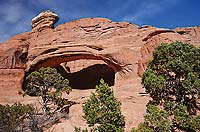
Klondike Bluffs was actually the area that first inspired the creation of a national park at Arches. Alexander Ringhoffer, a Hungarian immigrant who was drawn to southeast Utah in 1917 by mining and prospecting opportunities, began exploring the area now known as Klondike Bluffs sometime around 1922. Spellbound by the towering red sandstone pinnacles, Ringhoffer decided that the area would make an ideal tourist destination for passengers on the Denver and Rio Grande Western Railroad (DRGWR), which stopped at a station a few miles north at the town of Thompson.
Ringhoffer contacted the DRGWR to share his idea, and the following summer he escorted railroad officer Frank Wadleigh to the area, which he had named Devils Garden. Wadleigh was equally impressed with the scenery and wrote to the National Park Service (NPS) to suggest that the area be considered for a new national monument. Intrigued by the descriptions of the unique red rock, the NPS sent a surveying crew to Utah. But this was still a frontier in the early 20th century, and folks did their exploring without the aid of high-tech maps or GPS. So, in 1924 when the NPS surveyors attempted to follow the directions they were given, they actually ended up in another area, now known as The Windows.
They soon became aware of their mistake, and in 1925 a new survey party was sent. This time, they landed in a vast maze of fins and arches near Salt Valley. They still weren’t in the right place, but the name given by Ringhoffer stuck, and this area became the present-day Devils Garden.
In 1929 President Herbert Hoover signed the executive order to create Arches National Monument. Ironically, Klondike Bluffs, which had first inspired the creation of the park, was not included. In 1938 President Franklin Roosevelt approved an expansion of the monument’s area, and Klondike Bluffs was finally included within its boundaries. Arches became a national park in 1971.
Had the original surveyors gotten the directions right, you might be driving a paved road to Klondike Bluffs today and dodging baby strollers on a busy trail to Tower Arch. Consider the mistake a stroke of good luck that leaves us with a section of the park that still retains its isolated and rugged character.
Hiking Distance (round-trip): 3.4 miles–Difficulty: Moderate–Cautions: Remote location; steep rocky section at beginning of trail
Getting There
From Arches National Park Visitor Center:
Follow the main park road for 16 miles to the turnoff for Salt Valley Road, a short distance past the parking area for Sand Dune Arch. Take the unpaved road for about 7 miles to a junction, where you’ll have the option of turning left. Do NOT turn here, as this is a technical 4-wheel drive road. Instead, continue straight for another 50 yards or so to the next left turn, which is the road that leads 1 mile to the small parking area for the Tower Arch trail. Be sure and stop at the visitor center to ask about Salt Valley Road, as the park sometimes closes the route due to hazardous conditions.
|
 It’s that time of year where everyone preaches to you about drinking plenty of water, wearing hats and sunscreen, and not going hiking or biking or anything strenuous in the middle of the day. And it’s that time of year, where many people ignore such advice and end up with heat exhaustion, with heat stroke, or dead.
Visitors don’t want to waste a minute of their recreation time to enjoy Moab--we get it! But, we have daylight from 5 am to 9 pm, with the hottest time of day between noon and 4 pm. Do NOT go hiking or biking between the hours of 12 noon and 4 pm. Just don’t. There are seven hours of daylight during NON-peak heat between 5 am and noon. There are another five hours daylight and non-peak heat between 4 pm and 9 pm. Be heat smart!
Visitors to the desert Southwest don’t realize that “it’s a dry heat” is a real thing. It makes 100ºF (38ºC) feel like 80ºF (27ºC) in climates with an average humidity, but our dry desert air is quickly sucking the moisture out of your body. The problem is that you don’t realize you are sweating profusely, because it is usually evaporating off your skin faster than it can drip down your skin.
 Is heat illness limited primarily to the hiking and biking crowd? Nope. We recently encountered a family with a dead UTV on a trail only five miles from the main road and their tow rig. It was 5 pm and they had been sitting out there for 3 hours waiting for their friends to come help them. The whole family was flushed pink, and had long-since finished off their small supply of water. We helped them get back safely, but the dad kept saying “We had plenty of water for a short trip.” As long as nothing went wrong.
Same thing goes for 4wd vehicles. You might think you are safe since you have a vehicle in top condition with great air conditioning and gallons of water on board. But have you ever had a flat tire or got stuck in extreme heat? Even a healthy adult is at risk of heat illness with fifteen minutes of exertion in extreme heat.
My advice is to find other things to do during that noon to 4pm heat wave. Have a leisurely lunch at one of Moab’s delightful and air conditioned dining establishments. Take a dip in the pool at your hotel or the Moab Recreation Center, or find one of Moab’s shady swimming holes. Take a nap or read up on other great activities in the area in your air conditioned hotel room.
Exerting yourself outdoors in the hottest part of the day if you have a choice otherwise does not make you tough--it makes you a statistic. Keeping yourself and your family cool and safe is smart.Barlow Jeep Adventures can assist in planning a fun, safe adventure. Located at 1805 S. Hwy 191 (435) 259-3195. |