Hiking Distance (round-trip): Sipapu Bridge 1.2 miles, Kachina Bridge 1.5 miles, Owachomo Bridge .4 miles
Difficulty: Easy to moderate
Cautions: Steep drop-offs, some ladder climbing required
Even in the vast expanses of the western U.S., there are few places where you can see the dim glowing band of the Milky Way Galaxy without a telescope. In its remote location far removed from city lights, Natural Bridges National Monument sits under one of the darkest skies of any national park. In fact, in 2007 it was officially designated as the first International Dark Sky Park by the International Dark-Sky Association. But the dark sky is not what draws most people here. Despite the fact that it’s a bit off the beaten track, nearly 100,000 visitors come to see the park’s three mammoth natural bridges each year.
Natural bridges are created by the abrasive action of running water, and the three bridges here owe their existence to the streams that flowed through White Canyon and its tributary Armstrong Canyon. As flowing water erodes a stream’s outer banks, large looping bends develop in the stream channel. Sometimes, these meandering turns become so tight that the two sides of a loop eventually meet, leaving only a thin rock wall between them. As erosion continues to chip away at the wall on both sides, the water eventually breaks through and begins to take the shorter route rather than traveling around the loop. The opening in the rock wall gradually gets larger, and a natural bridge is born.
Hiking the Bridge Trails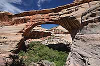
All three bridges can be viewed from the overlooks along Bridge View Drive, a 9-mile loop that circles through the park, but to appreciate their grandeur, you really need to stand beneath them and view them up close.
Towering 220 feet above the floor of White Canyon, Sipapu is the largest of the three bridges. This is also the steepest of the three bridge trails, and you’ll have to negotiate stairs, wooden ladders, and switchbacks. Descending the last part of the trail requires down-climbing steep slickrock using ladders and metal handrails. You’ll have excellent views of the bridge from a ledge just before this section, so if you’re skittish about doing the final descent, that’s all the farther you need to go.
The next bridge along the loop drive is Kachina, which is nearly the same height as Sipapu but has a smaller horizontal span. Geologically speaking, Kachina is the youngest of the three bridges. In 1992 a rock fall gouged out about 4,000 tons of rock from Kachina, a vivid reminder that the bridges won’t be here forever. Like Sipapu, you’ll need to traverse switchbacks, uneven stone steps, and use handrails to reach Kachina Bridge.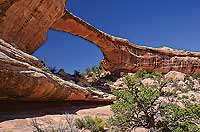
If you’re worn out from hiking to Sipapu and Kachina, you’ll be glad to know that the third and smallest bridge, Owachomo, is a much shorter trail—only .4 miles round-trip. If you’re short on time, a good option is to view the first two bridges from the rim overlooks and then take a quick walk down to Owachomo.
A Brief History of Bridge Names
The Southwest has been intermittently inhabited for the last 12,000 years, so it would be a stretch to say that geologic wonders like arches and natural bridges were “discovered” in the past 100 years or so. Prehistoric cultures, and even trappers and prospectors in the 1800s, undoubtedly encountered the bridges during their travels through the area.
What we can say is that by most accounts, the first white man to see the bridges was Cass Hite, who happened upon them while looking for gold in 1883. He named the bridges the President, the Senator, and the Congressman and began telling people about the “three whoppin’ natural bridges” he had seen.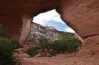
In 1903 local rancher J.A. Scorup and mining engineer Horace Long embarked on an expedition to photograph and measure the bridges. They also gave the bridges new names: Augusta (Long’s wife), Caroline (Scorup’s mother), and Edwin (Col. Edwin Holmes, who sponsored their trip). In 1904, National Geographic published Long’s report titled “Colossal Natural Bridges of Utah,” and the public was introduced to Natural Bridges on a grand scale.
In 1908 President Theodore Roosevelt established Natural Bridges National Monument as Utah’s first National Park Service unit, and a government survey party changed the bridge names to Sipapu, Kachina, and Owachomo, the Hopi words for “place of emergence,” “spirits,” and “rock mound.”
As an alternative to taking the three separate trails to the bridges, you can hike the 8.2-mile Loop Trail, which begins at the Sipapu Bridge trailhead and takes you to all three bridges. Be aware that the Loop Trail is not regularly maintained like the shorter trails from Bridge View Drive.
Getting There
From Moab:
Head south on Hwy 191 for 79 miles. Turn right on SR-95 and continue for about 30 miles to the signed turnoff for the park. Turn right on SR-275 and continue for 4.7 miles to the visitor center.
To read about more must-see sites and their history, check out Laurie Schmidt’s book, Utah Canyon Country: 20 Must-See Sites and Short Hikes, available on Amazon at: amzn.to/29pRRT7.
|