Moab Happenings Archive
Return to home

Scenic Roads Happenings September 2009

Sand Flats Road
By Rob Cassingham

The Sand Flats Road is most commonly known as the access point for the world-famous Slickrock Bike trail, but the route continues for another 17 miles on a well-maintained dirt road through a landscape that is nearly National Park quality in terms of scenic splendor. Sandstone fins, deep canyons, vast sweeping panoramas-there is much here to delight the eyes, and on many days you will have it all to yourself.

Originally, the Sand Flats Road was the main route between Moab and Castle Valley prior to the construction of the River Road, which is today’s Utah Highway 128. The mesa that the road crosses is named Wilson Mesa, but the early road was so often covered with deep windblown sand that Wilson Mesa became commonly known as Sand Flats. A rider on horseback could ride the distance in several hours, but a loaded wagon would bog down in the sand and could take two or three days to make the arduous trip. Today, regular road maintenance has made deep sand a thing of the past, and this road is generally passable to passenger cars in dry weather. Please note that the road does have some short sections of minor washboard , so watch your speed. Too much speed on a corner rippled with washboards can result in your vehicle’s trunk trying to pass your hood!

To begin this scenic drive, drive to the intersection of Main and Center Streets in downtown Moab, and reset your tripmeter to zero.
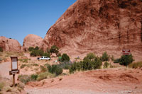
Mile 0 You are at the intersection of Main and Center Streets, adjacent the Moab Information Center. Proceed south on Main Street

Mile .3 Turn left on 300 South

Mile .75 Turn right on 400 East

Mile .8 Turn left on Millcreek Drive. There is a small convenience store at this intersection.

Mile 1.3 Stop sign, and a three way intersection. You are to continue east and proceed up the hill. This is the beginning of the Sand Flats Road.

Mile 2.1 The Moab Landfill is on the right. Several years ago, the landfill was designated “America’s Most Scenic Dump”.

Mile 2.9 You are at the entrance station for the Sand Flats Recreation Area, and a small fee is required to enter. Cars and trucks must pay a $5 fee, while bicycles and motorcycles are charged $2. The fee is good for 3 days of access. There are many splendid campsites to choose from in the Sand Flats Recreation Area. The nightly camping fee is $10 per vehicle.

Mile 3.1 RESET YOUR TRIPMETER. You are adjacent to the trailhead for the world-famous Slickrock Bike Trail.

Mile .4 The paved road transitions to dirt at the entrance to campsite cluster D .

Mile 1.9 The road enters a very scenic area of sandstone fins and superb campsites.

Mile 2.4 The road narrows as it climbs between two sandstone fins. There is only room for one vehicle at a time, so watch your speed and proceed with caution.

Mile 5.6 Juniper Campground

Mile 6.3 This is the trailhead for the Porcupine Rim Trail. There are pit toilets and water here. Negro Bill Canyon is to the right of the Sand Flats Road, and Rill Canyon drops away on the right side. The Porcupine Rim Trail is widely considered one of America’s best mountain biking trails. This is excellent habitat for porcupines, and the presence of the prickly varmints is the reason behind the name. Over the next two miles, the road hugs the edge of Rill Canyon.

Mile 8.3 You have climbed up and out of Rill Canyon.

Mile 10 Some very nice views of the La Sal Mountains to the south. The density of Piñon Pine and Utah Juniper has increased dramatically. This type of forest is called a ‘pygmy forest’. The density of trees rivals that found in more ‘traditional’ forests, but few trees stand over 20 feet tall.

Mile 10.3 The cattle guard marks the boundary of National Forest land.

Mile 10.6 A road to the right leads to the Castle Valley overlook, and is a truly stunning, classically western panorama. The access road is .6 miles long one-way and is suitable for light duty 4x4 vehicles, such as the Toyota RAV4 and all-wheel drive Subarus for .5 miles. The final .1 mile may require a vehicle with slightly more ground clearance. If you decide to drive the overlook road, note your mileage and adjust the mileages given in this road log accordingly.
There is a pit toilet a short distance up this road.

Mile 11.7 The road passes a short section studded with sandstone bluffs, Quaking Aspens and Ponderosa Pines. Several of the larger Ponderosa pines are growing improbably out of narrow fissures in the sandstone.

Mile 12.8 A large boulder sits on the right side of the road with an interesting ‘tunnel’ arch. Just beyond this point, the road tops out and passes through more of the Piñon-Juniper forest and several houses. Over the next few miles the road can have sections of mild washboard surface.

Mile 17.0 The Sand Flats Road ends at the intersection with the La Sal Loop Road. For more information on this scenic paved road, please refer to the August 2009 issue of the Moab Happenings. Turning left at this point will take you to Castle Valley, and a turn to the right will take you back to Moab by the fastest way possible.

The Moab Happenings hopes you have enjoyed your scenic drive, and we remind you that this is only one of dozens of enjoyable scenic drives in the area. Please look for an additional road log to be detailed in each monthly issue of the Moab Happenings!


Return to Archive Index
return to home
 
Return to home