Scenic Roads Happenings April 2010
Mill Canyon, Klondike Bluffs, Copper Ridge
Article and photos by Rob Cassingham
This month, the Moab Happenings will take you on a journey through time to a stagecoach station, dinosaur fossils and tracks, and old copper mining operations. These three road logs are all accessed from US Highway 191 north of Moab. The first and third routes detailed (Mill Canyon and Copper Ridge) are normally easily traveled by standard passenger vehicles. The second, Klondike Bluffs, has a short section that will challenge stock 4x4 rigs. Please drive carefully, and bring plenty of water just in case!
Mill Canyon
Drive north of Moab on US 191 15.4 miles from the intersection of Main and Center streets in downtown Moab. Approximately 100 feet north of milepost 141, turn left (west) and reset your trip meter.
Mile 0.0 Continue west on the dirt road. The route is normally passable to passenger cars, but after rain storms large mud puddles may prevent travel. 4x4 vehicles should not encounter any difficulties.
Mile 0.6 Keep to the left at this intersection.
This fossil was a scapula (shoulder blade) of a long-necked sauropod. |
Mile 1.1 Right at this intersection. The road to the left leads to the Halfway Stage Station, which you may visit on your return trip.
Mile 1.4 The road crosses a shallow wash. After very heavy rains, this dip may become washed out. Watch your speed!
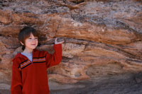
Mile 1.8 The road ends at the Mill Canyon fossil walk trailhead. This easy stroll is well-marked with interpretive signs, making it easy to view fossilized bones left from Jurassic dinosaurs. There are fossils left behind by Allosaurus (a massive predator), Stegosaurus (famous for having bony plates along its spine and spikes on the tail) and Camarasaurus (a long-necked sauropod similar to “Brontosaurus”). At the last interpretive sign on this .25 mile hike is a sign identifying Determination Towers, which are visible at the head of the canyon farther west. If you look across canyon to your left, you may be able to spot the two remaining walls of an old copper mill. This old copper mill, never very productive and long defunct, is the reason for Mill Canyon being named thusly.
When finished, please return to US Highway 191 the same route you traveled. If you wish to visit the remains of the Halfway Stage Station first, proceed back toward the intersection noted at Mile 1.1, above. Reset your trip meter at the intersection
The walls of the Halfway Stage Station still await the next stagecoach. |
Halfway Stage Station
Mile 0.0 You are at the marked intersection. Drive south.
Mile 0.1 Right at this intersection.
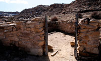
Mile 0.3 Halfway Stage Station. When the railroad finally entered Grand County, the closest railroad stop to Moab was at Thompson Springs, some 35 miles distant. Stagecoaches were utilized to transport passengers and mail to Moab, which took eight hours to make the trip. Freight bound for Moab was loaded onto wagons, and the trip for freighters took two days. The Halfway Stage Station was, as the name implies, half way between Moab and Thompson. Stagecoaches would stop here to let the horses rest and the passengers have lunch, but freighters would stop for dinner, stay overnight, and depart after breakfast. This stage station was in use from the mid-1880s until the late 1890s when it was replaced by another facility. The ‘new’ Halfway Stage Station was in use until the 1920s, but no traces of it remain.
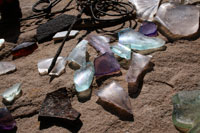
Colorful broken glass found at the Halfway Stage Station. Taking historic artifacts is illegal.
|
When you are ready, head back to US Highway 191 and continue north for 1.1 miles.
Klondike Bluffs
At .1 mile past milepost 142, you will see a marked turnoff on the right for Klondike Bluffs. This route does have some obstacles that will challenge stock 4x4 vehicles, and getting high-centered and/or mild body damage IS a possibility. Visitors that wish to view the Klondike Bluffs dinosaur tracks but do not have a vehicle capable of the whole route will have to make the easy hike another .5 mile to the first dinosaur tracks, and an additional .6 mile to the best set of tracks.
Mile 0.0 Reset your tripmeter. You are at the parking lot cattle guard that marks the beginning of this road log. This is a popular mountain biking route, so please drive courteously and watch for bicyclists!
Mile 2.6 Turn left at this intersection. You will be paralleling some greenish slopes on your right. Approximately 145 million years ago, these green slopes were deposited in river flood plains.
Mile 2.9 A cattleguard and an informational kiosk is the landmark for this mileage.
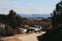
Beautiful vistas and dino tracks reward Klondike Bluffs visitors. Jeep courtesy of Canyonlands Jeep Adventures.
|
Mile 3.1 Cross the shallow wash.
Mile 3.7 Right at this intersection.
Mile 4.0 A rock ledge is the first real obstacle on this trail. Not all vehicles will surmount it.
Over the next .3 mile, you will come across other obstacles, including a tight squeeze past a menacing boulder, a shallow wash that can become too eroded to drive, and more rock ledges.
Mile 4.5 You have reached a large expanse of white slickrock. The first dinosaur tracks are visible near the soft red soil to your left as soon as you reach the white sandstone. Geologists call this sandstone “Moab Member” of the Curtis Formation, but 160 million years ago it was a white sand beach.
As you continue up the trail for another .6 miles, keep close to the reddish soil (usually 10 to 20 feet distance) on your left and watch for more dinosaur tracks between you and the red soil. Many of the tracks have a circle of stones around them, making the tracks easier to spot. Take great care not to drive over them!
The Klondike Bluffs have many theropod tracks. This set is among the best.
|
Mile 5.1 The best set of dinosaur tracks on this road log. They are very close to the reddish slope, but may not be as well-marked. If you do not see them, know that you have gone too far if the ‘road’ curves around a red projection of soil and then starts heading downhill. The tracks are just before this point.
The Klondike Bluffs trail continues for another mile or two before ending at a fence marking the boundary of Arches National Park. Though the view from the trail’s end is spectacular, there are very few dinosaur tracks to be seen and is beyond the scope of this road log.
When you are ready, drive back to US 191 via the same route you just traveled.
Copper Ridge Sauropod Trackway
To access this site, continue north on US 191 6.5 miles from the start of the Klondike Bluffs trail. The turnoff is about .5 mile past milepost 148. The road will be on your right (east), and crosses railroad tracks as soon as you leave the highway. This road is easily passable to all passenger vehicles except right after a rainstorm, which may leave short muddy stretches.
Mile 0.0 Cross the railroad tracks.
In a short distance you will pass a sign that reads “Dinosaur Tracks 2”. Navigation on this route is very straightforward-simply stay on the main road. You will travel south past a low bluff, after which the road turns back to the north.
Mile 2.0 You are at the trailhead for the Copper Ridge Sauropod Trackway. The tracks can be found 500’ distant from the parking area.
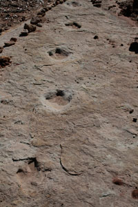
Some 150 million years ago, the sandstone was deposited in a shallow river, and it appears to have been the scene of a Jurassic drama. The star attraction at this site are the deep circular impressions left from a sauropod as the creature was making a hard turn to the right. Sauropod tracks are rare (this was the first site discovered in Utah, back in 1989), and changes in direction preserved in any dinosaur trackways are also very rare, making this site very special indeed. Likely candidates for the trackmaker are Diplodocus, Camarasaurus, or Apatosaurus (better known by the popular name “Brontosaurus”). Some paleontologists speculate the sharp turn was made to avoid predation, possibly from one or more Allosaurs.
In addition to the sauropod tracks, there are trackways from four theropods present (again, likely Allosaurus). Some of the smaller tracks may only be visible in low-level light. The theropod tracks just slightly uphill to the east of the sauropods are particularly interesting-they show an alternating stride of five feet and four feet between tracks. It appears that this predator may have been injured and was limping.
If you were to continue hiking up the old road, you would eventually top out on Copper Ridge, which affords an excellent panorama of the surrounding country. Copper Ridge was once the location of a copper mining operation similar to the one found at Mill Canyon, but far more extensive.
The Moab Happenings thanks you for visiting Moab, and we welcome you back to Moab as often as you can visit. Be sure to check out every issue of the Moab Happenings for more information on local events, great hiking and biking, restaurant and lodging guides, and more spectacular local drives! |