Have you ever opened up satellite view in Google Maps to get directions, only to find yourself zooming around to explore what your backyard, neighborhood, and city look like from above? Scientists use images like these to investigate patterns in vegetation, soils, and geology across vast landscapes. They call this method of identifying and measuring objects on the Earth’s surface with photos taken by planes and satellites “remote sensing”.
Radar is one of the best-known forms of remote sensing, used for everything from weather forecasts to speeding tickets. A radar instrument sends out radio waves and measures how long it takes them to return to the instrument. When radio waves hit a nearby object, they bounce back quickly; radio waves that hit distant objects take longer to come back. The differences in return times reveal where objects are and how fast they are moving. Radio waves can travel through several feet of sand, so archaeologist have used radar to locate buried stone ruins in southern Utah.
A newer technique, called Light Detection And Ranging (LiDAR), can make more detailed maps by using laser beams instead of radio waves. The tiny dots of light that lasers create allow LiDAR systems to detect small variations in surfaces. Scientists at Grand Canyon use LiDAR to map sandbars of the Colorado River and learn about how they change with different river flows. These sandbars provide shallow waters where native fish can spawn, and excellent campsites for river rafters.
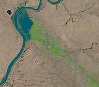
Measuring the same locations over many years provides valuable information about how and why landscapes change. In 1972, NASA launched a satellite program called Landsat to take photos spanning the entire globe every two weeks. The images are low-resolution compared to what you’ll find on Google Maps – each pixel covers an area the size of two basketball courts. However, they provide enough detail to show changes in vegetation over several decades. Ecologists are using this information to understand how drought affects different types of plants on Colorado Plateau rangelands. Climate change is causing more frequent and severe droughts in the Southwest, so understanding how vegetation may shift under these conditions is important for the future management of public lands.
 |
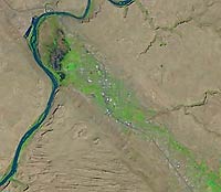 |
| Landsat images of Moab in June 1984 (left) and June 2019 (right). |
Remote sensing is a powerful scientific tool that helps us understand the past, present, and future of the dynamic landscape of the Colorado Plateau.
|
Every winter Southeastern Utah and Western Colorado are visited by bald and golden eagles looking for an ideal site to nest. A few of these eagles decide to call the cottonwood trees – nestled between sandstone cliffs and the Colorado River below – their winter home. Beyond the bald eagle, many other species of birds call this narrow band of riparian habitat running through the desert climate of the Colorado Plateau home. Canyon wrens, killdeer, belted kingfisher, great blue herons, and red-tailed hawks are just a few of the species seen along the Colorado River in late winter.
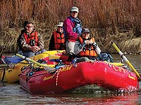 |
| CFI Eagle Float 2018
(Tom Haraden photo) |
Join us and view these majestic creatures on Saturday, February 29 on Canyonlands Field Institute’s (CFI) annual Eagle Float on the Colorado! On this day long excursion we will float from Loma, Colorado to Westwater Ranger Station, Utah. A mostly smooth, 25-mile stretch of river leads us through Horsethief and Ruby Canyons and their red sandstone cliffs. Throughout the trip, we will keep our eyes and binoculars pointed towards the cliffs edge, cottonwood trees, and sky above for signs of our avian friends.
You don’t have to be an expert birder to enjoy the Eagle Float. Accompanying us are members of the Moab Bird Club and staff from HawkWatch International who are all excited to answer any ornithological questions you might have. In addition to our wonderful birding volunteers we will also have guidebooks and printouts on hand to help identify birds as we see them.
Beyond birding, we will also see some incredible geology. As we float through Ruby canyon we enter into the Black Rock section. This geologic oddity is composed of a rock layer called the Vishnu schist that has been dated to 1.7 billion years old. Among these rocks, we will talk a bit about the endangered fish species that live in this section of the river.
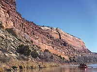 |
| CFI Eagle Float 2018
(Tom Haraden photo) |
Our group will be in rafts for the majority of the day, floating quietly as much as possible; motors will be used at times to make this 25-mile stretch in one-day. Occasionally, we will join up to share information, hear comments from our guest experts. Throughout the day we will make several stops on shore to stretch and have lunch. Snacks, water, and lunch are all provided by CFI.
Canyonlands Field Institute is a non-profit outdoor education organization whose mission is to increase awareness and appreciation for the Colorado Plateau through direct natural and cultural experiences. All profits help support youth and school outdoor education programs.
For more information about this seminar or tours CFI provides go to our website at cfimoab.org, call us at 435-259-7750, or by email at info@cfimoab.org.
 Southeast Utah 500 Women Scientists
Mission and Values: Southeast Utah 500 Women Scientists
Mission and Values:
Our Mission:
• To share the importance of science.
• To support one another as a community of women scientists in Southeast Utah
• To be in service in the name of science to the communities of Southeast Utah.
Our Values
• Being a supportive group for women scientists in Southeast Utah
• Advocate for inclusivity in our group and in science at large
• Increase scientific literacy for locals and tourists
• Mentor and support students of science (especially girls) |
|