Hiking Happenings
April 2006
The Big
by Rory Tyler
Day Canyon |
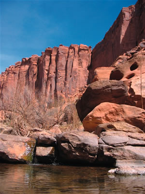
If bigger is better then
Moab’s terrain is better than most. The chief geological
component of the Big in Moab is Wingate sandstone. When
you see sheer, red vertical cliffs hundreds of feet high
stretching on for miles and miles, that’s Wingate
sandstone. At Canyonlands National Park and Dead Horse
Point State Park you can drive right up to the edge of
the Wingate cliffs that ring the great canyon and peg your
personal Wow-meter with ease. But getting your itty-bitty
boots on the ground and doing the bug-on-the-wall crawl
is even more effective.
Wingate sandstone formed about 200 million years ago in
a vast, sterile desert and was revealed in the more recent
millions by the canyon-cutting action of the Colorado River.
The cliffs often sport a gleaming black sheen. This comes
from a peculiar substance known as desert varnish. To the
best of our knowledge, bacteria living on the cliff walls
digest dust and rock over untold centuries, leaving a black
manganese-oxide residue on the Wingate and other geological
formations.
Because of the decidedly vertical character of most Wingate
exposures, the majority of people who know it intimately
are rock climbers. For those of us without whipcord physiques
and nerves of steel, getting into the Wingate can pose
a problem. Good Wingate hikes are limited, and rarer still
if you’re not ready to climb and claw and struggle…not
everyone’s cup of tea. But there are a few places
in the Wingate that lend themselves to the pedestrian pursuits
of the less gifted.
If you like it when things are looking up, Day Canyon fills
the bill. It is a narrow, rocky chasm rimmed by perpendicular
precipices, soaring columns and towers. Day Canyon makes
you feel like one of those teeny beetles crawling around
in a cactus blossom. All that color and form ringing you
round and you’re there at the heart of it.
To get to Day Canyon turn on the Potash Road north of town,
then 11.5 miles to the mouth of the canyon - a deep, narrow
defile on the right. The trailhead has a wire-mesh gate
and broken-down fence across its mouth. It was once a cattle
trail, then a 4-wheel drive road (now closed to cars),
and is maintained these days mostly by rock climbers. When
the trail turns left after a few hundred yards, you have
a choice of staying in the thick brush in the canyon bottom
or crossing the wash and climbing onto a rocky bench on
the right. Go for the bench unless you prefer doing the
Fanghorn Forest shuffle through thickets of invading tamarisk.
Both trails rejoin in less than a half mile. For a longer
walk, there’s still enough of the old cattle trail
left to climb out. Round trip is seven or eight miles.
To start at the top, try Hell Roaring Canyon. A white sandstone
bench wends along the canyon rim for miles for nice low-impact
walking. Here, you can really see how the Wingate sheers
off once the underlying geological formations have eroded
away.
To get to Hell Roaring Canyon take the Deadhorse Road,
Highway 313, for 8 ½ miles and turn right on a
gravel road at the far end of the giant red mesa you’ve
been paralleling for a few miles. (It’s made from
Entrada sandstone.) When the road turns left and splits,
go straight on the Spring Canyon fork. Four miles from
Hwy 313 you cross a cattle guard. Turn left on the dirt
track, go another hundred yards, and the rest is self-explanatory.
The head of Hell Roaring was a key point in one of the
region’s main Indian routes for thousands of years.
An ancient trail leads from the top of the canyon to the
floor, but good luck finding it.
Last but not least, the transect. My preference is to start
from the bottom, using up the most energy while I’m
still fresh. Kane Creek Road (turn at McDonald’s)
leads you to some fine Wingate transects. The canyon widens
four miles from the cattle guard where the road changes
from paved to gravel, where a dirt road takes off to the
right. This former uranium mining road, now a mountain
bike trail, follows the slope of the geology up and up
to some great vistas.
An ambitious, experienced hiker will drive another mile
and a half to the crest of a hill topped by a mottled,
brick red Cutler sandstone outcrop. A ridge on the left
leads to a gap in the cliff line. This is a hard-core,
off-trail route. The top consists of several wildly branching
canyons that start shallow and entrench radically as they
converge to the north. The Wingate undulates and rolls
here, rather than dropping precipitously, because the erosion
hasn’t cut through to the bottom of this sheer-prone
formation. Once you know this way you’ll have a lot
to do for quite a while, but be careful. It’s remote
and confusing, so pay careful attention to where you’re
going and where you’ve been and don’t take
chances. (A lot of local hikers have thanked me for writing
this column. This last route is really for you and I hope
you have a lot of fun with it.)
Rory Tyler is available for cowboy
poetry/campfire song gatherings which include lore, science,
history and lies of the Moab area. (Suitable for all
age groups). Rates are negotiable. Give Rory a call at
435-260-8496.
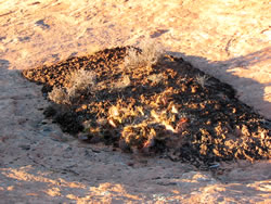
Cryptobiotic soil
garden
|
|