HIKING HAPPENINGS
August 2007
Climbing Manns
Peak – Hold On To Your Hat
by Marcia Hafner
 The
moment I step out of the jeep at the trailhead to Burro Pass,
I step back in again for a quick change of clothes - off
come my shorts, on go my hiking pants. At a high elevation
even in the summer, it is hard to guess what the weather
will be and I always come prepared with a fleece top, long
pants, and a windproof raincoat. The
moment I step out of the jeep at the trailhead to Burro Pass,
I step back in again for a quick change of clothes - off
come my shorts, on go my hiking pants. At a high elevation
even in the summer, it is hard to guess what the weather
will be and I always come prepared with a fleece top, long
pants, and a windproof raincoat.
Twenty-five to thirty million years ago, the intrusive molten
magma cooled into igneous rock and overlying, less-resistant
sandstone eroded away resulting in the formation of the La
Sal Mountains. This mountain range covers an area 25 miles
long (north-south) by 15 miles wide (east-west) and is the
second highest range in Utah after the Uintas. Collecting
moisture from westerly air currents, they recharge the aquifers
and water table for Moab and other nearby communities.
A prominent landmark on the Old Spanish Trail, the name “La
Sal” was originally recorded in the 1776 journals of
Dominquez and Escalante, two Franciscan friars on an expedition
to find a route between the Catholic missions in California
and New Mexico. They were also interested in claiming more
land for Spain and Mexico. Their Ute guides had referred
to this mountain range as “Sierra de la Sal” (“The
Salt Mountains”) for the salt deposits at the base
of the range. With twelve peaks over 12,000 feet, they are
divided into three distinct groups; north, middle and south.
There are two passes: La Sal Pass (10,125ft.) and Geyser
Pass (10,500 ft.) Geyser Pass, however, has nothing to do
with a geyser. Instead it is named after Al Geyser, an early
cattleman. Tomasaki Peak, Mount Waas and Mount Tukuhnikivatz
were named after Ute leaders by members of the Hayden Survey
in 1875. Tradition suggests that the translation of Tukunikivatz
from the Ute language is “place where the sun sets
last.” The highest peak, Mount Peale (12,721 feet)
was named after Albert Charles Peale, a geologist on the
Hayden Survey team.
 Our
goal for the day, Manns Peak (12,272 feet), is the
fifth highest peak. It is my favorite peak to climb
because the route up the south ridge is easy to follow
and the distance from the trailhead to the summit is
much shorter than other peaks above 12,000 feet. That
eliminates both the fear of getting lost and the long
grunt to the top. The added bonus is there is a minimum
of talus (piles of loose unstable rock) so the footing
is more secure. Our
goal for the day, Manns Peak (12,272 feet), is the
fifth highest peak. It is my favorite peak to climb
because the route up the south ridge is easy to follow
and the distance from the trailhead to the summit is
much shorter than other peaks above 12,000 feet. That
eliminates both the fear of getting lost and the long
grunt to the top. The added bonus is there is a minimum
of talus (piles of loose unstable rock) so the footing
is more secure.
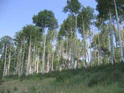
At the beginning of the trail there is a turnstile next to
the cattleguard. A short walk through aspens, firs, and spruce
with one easy stream crossing brings us to a lush meadow.
In mid-June aside from dandelions and wild parsley, it’s
too early for the big production of wildflowers. To our right
we can now see Manns Peak and a little further south Tomasaki
Peak with the ridge that connects the two of them. On the
talus slopes we hear the shrill, piercing calls of marmots
and pikas. The marmot, a high elevation relative of the groundhog,
goes into hibernation for the winter. Pikas are related to
rabbits and with their small rounded ears and no visible
tail, look like brown guinea pigs. Active in their dens throughout
the winter, in late summer they gather green plants for their
cold weather food supply.
It is not unusual to see golden eagles and today an immature
with classic white markings circles overhead. Two curious
mule deer take a long look at us before ambling off. Secretive
elk thrive in the backcountry and are seldom seen.
On the switchbacks up the slope to Burro Pass, we walk cautiously
across a lingering snowfield. We have now gained approximately1,000
feet and are at an elevation of 11,180 feet. It is time to
take a break!
Now more refreshed we leave the main trail which continues
north down the other side of the pass to either Warner Lake
or Oowah Lake. Instead we go up the northeast ridge following
a primitive trail until Manns Peak comes into sight again.
Tempting as it is to stay on this easy-walking trail, that’s
my signal to veer off it before it starts going down away
from Manns Peak to Deep Creek. I swing left to avoid the
talus slope directly ahead of us.
In the tundra the wind is fierce and we’re putting
on an extra layer of clothes. The higher we march, the more
fierce and bitter the wind becomes. Almost knocking us off
our feet, my hiking partner is wondering when I’ll
suggest we turn back. I keep hoping that she’ll make
the suggestion! But the close-looking summit that still feels
so far away keeps teasing us on. Trudging along, bucking
a now raging wind, we finally take refuge in the rock shelter
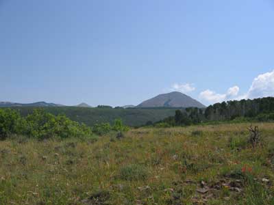
on top where there’s a dynamite view of nine of the
twelve peaks over 12,000 feet. East into Colorado, we are
looking at the snow-capped San Juan Mountains, the Uncompahgre
Plateau, Paradox Valley and the canyons of the Dolores River.
On the northeastern slope directly below us is Beaver Basin
and beyond that is Castle Valley. We shift our position for
a westerly, windblown look at down-sized Moab Valley and
Spanish Valley. Further out we have a vision of the Henry
Mountains with the rugged floorboard of the canyonland country
in between. Being knocked around on the way up was a small
price we had to pay for the dramatic scene we’ve just
witnessed.
To get to the Burro Pass Trailhead, drive south eight miles
on highway191 out of Moab. Then take the left hand turn to
Ken’s Lake. Go half a mile to the stop sign and take
a right on to Spanish Valley Drive which turns into the La
Sal Loop Road. Twenty miles after leaving Moab there will
be a sign for a right hand turn on to the Geyser Pass Road.
Another eight miles gets you to the pass. It is a dirt-washboard
road and the last few miles, which are impassable in the
winter, is narrow so be prepared to pull over or back up
for oncoming vehicles. Not far past Geyser Pass take a left
fork and continue approximately another mile. Then turn left
at the sign for Burro Pass. For the last half mile to the
trailhead, four-wheel drive is highly recommended.
A word of caution: Mountains create their own weather. When
the clouds start to build, keep in mind conditions can change
in a hurry. If you’re on an open, exposed area and
there’s lightning close by, get down to more sheltered
areas as fast as you can.
|
Biological
Soil Crust (aka)
Cryptos (krip’ tose):
The surface of
Moab’s desert is held together by a thin
skin of living organisms known as cryptobiotic
soil or cryptos. It has a lumpy black appearance,
is very fragile, and takes decades to heal when
it has been damaged. This soil is a critical part
of the survival of the desert. The cryptobiotic
organisms help to stabilize the soil, hold moisture,
and provide protection for germination of the seeds
of other plants. Without it the dry areas of the
west would be much different. Although some disturbance
is normal and helps the soil to capture moisture,
excessive disturbance by hooves, bicycle tires
and hiking boots has been shown to destroy the
cryptobiotic organisms and their contribution to
the soil. When you walk around Moab avoid crushing
the cryptos. Stay on trails, walk in washes, hop
from stone to stone. Whatever it takes, don’t
crunch the cryptos unless you absolutely have to! |
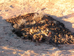
Cryptobiotic soil
garden
|
|
|