HIKING HAPPENINGS
November 2007
Finding Hidden
Valley
by Marcia Hafner
 The
name speaks for itself. It can’t be seen until you’re
almost in it. I’ve walked this trail many times and
I still have trouble guessing exactly where the opening is
on the rim that allows for easy access into Hidden Valley.
Mentally I know where it must be but visually it’s
disconcerting not to be able to pick it out. Even after climbing
the 680 feet to the rim, it still stays evasive, not willing
to give up its secret identity until I step into its wide,
expansive grasslands. The
name speaks for itself. It can’t be seen until you’re
almost in it. I’ve walked this trail many times and
I still have trouble guessing exactly where the opening is
on the rim that allows for easy access into Hidden Valley.
Mentally I know where it must be but visually it’s
disconcerting not to be able to pick it out. Even after climbing
the 680 feet to the rim, it still stays evasive, not willing
to give up its secret identity until I step into its wide,
expansive grasslands.
This trail has probably been used for several thousand years
starting with the Basketmaker culture that were here for
just eight to nine hundred years. Mainly hunter-gatherers
in this part of Utah, they produced many of the petroglyphs
in this area.
To get to the Hidden Valley Trailhead, start from Center
and Main Street and drive south on highway 191 three and
a half miles. Turn right at a stucco building on to Angel
Rock Road. If you go whizzing on by the Shell station you
have missed your turn by about half a mile! Drive the short
distance on Angel Rock Road until it dead-ends. Then turn
right on to Rimrock Road and follow the signs to the trailhead
where there’s an 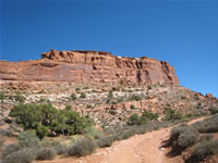 informational
sign at the beginning of the trail. It’s two miles
to the pass at the north end of Hidden Valley where there’s
a long panel of petroglyphs. Allow three hours for the round
trip hike. informational
sign at the beginning of the trail. It’s two miles
to the pass at the north end of Hidden Valley where there’s
a long panel of petroglyphs. Allow three hours for the round
trip hike.
The Hidden Valley Trail goes through Behind The Rocks Wilderness
Study Area (WSA) and motorized vehicles are not allowed.
Since the pre-existing trail predates the wilderness study
area bicycles may use it but all riders must stay on the
trail.
On my most recent hike into Hidden Valley, the nip in the
air had put me in an autumnal mood. Despite the lack of large
deciduous trees anywhere on this trail the evidence of fall
still held with the rabbitbrush and snakeweed in their full
flush of seasonal yellow blooms. Scattered sunflowers and
asters also made their own statement of summer coming to
an end. Even the subdued grass blended in with the fall color
scheme.
At the beginning of my walk the trail register is my reminder
for what comes next; a short section of steep, pebbly terrain
that 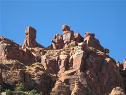 adds
up to an uncomfortable walking-on-marbles feeling. I always
approach it with caution especially when I’m coming
down because it easily slips out from underfoot. Making it
safely past that, I’m at my favorite spot on this upward
section of the trail that is a hollowed out streambed with
a healthy serviceberry tree growing in it. The moisture collects
here making it lusher and in the summer a wee bit cooler.
Soon after that the serious switchbacks (all eleven of them)
join in with the ledgy, high rock stepping part of the trail
to the rim. As I wind around each switchback I gaze down
at my truck to gauge my gain in elevation and that makes
me aware of the good progress I am making up to the rim.
With every glance to the east, there are full views of the
La Sal Mountains now freshly dusted with snow. adds
up to an uncomfortable walking-on-marbles feeling. I always
approach it with caution especially when I’m coming
down because it easily slips out from underfoot. Making it
safely past that, I’m at my favorite spot on this upward
section of the trail that is a hollowed out streambed with
a healthy serviceberry tree growing in it. The moisture collects
here making it lusher and in the summer a wee bit cooler.
Soon after that the serious switchbacks (all eleven of them)
join in with the ledgy, high rock stepping part of the trail
to the rim. As I wind around each switchback I gaze down
at my truck to gauge my gain in elevation and that makes
me aware of the good progress I am making up to the rim.
With every glance to the east, there are full views of the
La Sal Mountains now freshly dusted with snow.
The chukar often sound off with their “chuk-chuk-chuk” alarm
call. Sometimes these handsome, medium-sized upland game
birds, which have been introduced from the Middle East, blow
their cover and flush out on a frenzied, downhill whirl of
wings. If I’m lucky I’ll even have a chance to
see their bold black markings before they spook. Aside from
Castle Valley, this is the only place I ever see them.
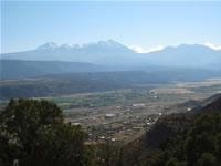 At
the rim, I always take a break to kick back and absorb
the view of Spanish Valley. I can pick out a lot from
my high-ended perch – Rim Village, Spanish Trail
Arena, Highway 191, White’s Ranch, Spanish Valley
Drive, the golf course and the OK RV Park. In early
fall, this break is particularly delightful because
the mourning doves find this ridgeline to their liking
where they plaintively coo their duets. At
the rim, I always take a break to kick back and absorb
the view of Spanish Valley. I can pick out a lot from
my high-ended perch – Rim Village, Spanish Trail
Arena, Highway 191, White’s Ranch, Spanish Valley
Drive, the golf course and the OK RV Park. In early
fall, this break is particularly delightful because
the mourning doves find this ridgeline to their liking
where they plaintively coo their duets.
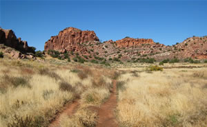
The steepest, hardest part of the trail is over and I cross
the boundary to the Behind The Rocks Wilderness Study Area.
After a short, uphill bump through the pinyons and junipers,
the view at last opens up and the broad shelf of Hidden Valley
stretches out ahead of me. To my left is the formidable backdrop
of Wingate sandstone walls that jealously guard Hidden Valley
from that side. Half way across the valley I can see a huge
square rock to the right of the trail that looks like a big
house. After passing the rock house, the trail makes a gradual
ascent to a low pass where there are dramatic views of Poison
Spider Mesa, Island In The Sky section of Canyonlands National
Park, and the large sandstone fins of Behind The Rocks. It
then drops down .3 miles to meet up with the Moab Rim Jeep
Trail. If you set up a shuttle you can make a loop hike by
following the trail west to the Moab Rim Trailhead on Kane
Creek Blvd. It’s a great hike up to the Moab Rim and
back down to the river.
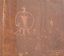 To
find the petroglyphs, at the pass follow a trail to
the right walking alongside the south-facing wall.
These panels depict hunting and fighting scenes and
are filled with the figures of big horn sheep, deer,
tracks and odd human figures including one inside of
another. To
find the petroglyphs, at the pass follow a trail to
the right walking alongside the south-facing wall.
These panels depict hunting and fighting scenes and
are filled with the figures of big horn sheep, deer,
tracks and odd human figures including one inside of
another.
In the summer during most of the day there is little shade.
To avoid the heat, go early in the morning or late in the
afternoon. At that time of year it is crucial to carry plenty
of water. Ironically in the winter the trail to the rim captures
the shade for most of the day. Consequently when it snows,
it takes a long time to melt off and becomes a treacherous
slide-on-ice walk. When it’s like that I pick a different,
sunnier trail to hike on.
Spring and fall are the ideal times to explore the treasures
of Hidden Valley but be prepared to meet up with other hikers.
It’s popular with both the locals and the visitors.
|
Biological
Soil Crust (aka)
Cryptos (krip’ tose):
The surface of
Moab’s desert is held together by a thin
skin of living organisms known as cryptobiotic
soil or cryptos. It has a lumpy black appearance,
is very fragile, and takes decades to heal when
it has been damaged. This soil is a critical part
of the survival of the desert. The cryptobiotic
organisms help to stabilize the soil, hold moisture,
and provide protection for germination of the seeds
of other plants. Without it the dry areas of the
west would be much different. Although some disturbance
is normal and helps the soil to capture moisture,
excessive disturbance by hooves, bicycle tires
and hiking boots has been shown to destroy the
cryptobiotic organisms and their contribution to
the soil. When you walk around Moab avoid crushing
the cryptos. Stay on trails, walk in washes, hop
from stone to stone. Whatever it takes, don’t
crunch the cryptos unless you absolutely have to! |
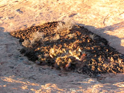
Cryptobiotic soil
garden
|
|
|