HIKING HAPPENINGS
September 2008
Moonlight Meadows – Downhill All The Way
by Marcia Hafner
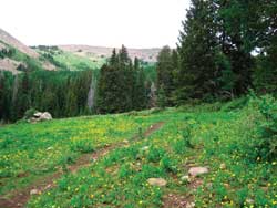
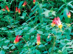 If you have been yearning for the soothing coolness of a high country walk through acres and acres of lush knee-high grass, then Moonlight Meadows is the ideal location for you. Each spring-fed meadow is a carpet of green that sparkles with the yellow hues of dandelions and buttercups. Along the banks of bubbling, playful streams, wild geraniums, red columbines and pale bluebell flowers nod their lovely heads in the cooling mist. To enhance your alpine experience, they are woven within a patchwork of aspens, firs and spruce where the minuscule, but oh-so-precious beauty of violets is shyly tucked away in shaded relief. If you have been yearning for the soothing coolness of a high country walk through acres and acres of lush knee-high grass, then Moonlight Meadows is the ideal location for you. Each spring-fed meadow is a carpet of green that sparkles with the yellow hues of dandelions and buttercups. Along the banks of bubbling, playful streams, wild geraniums, red columbines and pale bluebell flowers nod their lovely heads in the cooling mist. To enhance your alpine experience, they are woven within a patchwork of aspens, firs and spruce where the minuscule, but oh-so-precious beauty of violets is shyly tucked away in shaded relief.
I, however, am saving the best news for last. If you start at the trailhead on the Geyser Pass Road, it is downhill all the way to Oowah Lake. In the steep mountainous terrain of the La Sal Mountains, it doesn’t get much better than that.
 To avoid the uphill grind back to the Geyser Pass Road, you have to arrange a shuttle. To do this, go to Oowah Lake first. To get there from Moab, go south on Highway 191 for approximately eight miles. Turn left at the Ken’s Lake - La Sal Loop Road sign. Then take a right at the dead-end, which becomes the La Sal Loop Road. Continue 4.5 miles past the turn off for the Geyser Pass Road to a narrow dirt road (just before the bridge) that leads to Oowah Lake. This five-mile road is fine for cars but because of the tight switchbacks, trailers and RV’s are not advised. Leave one vehicle at that trailhead and drive back in the other to the Geyser Pass Road, which is graded and passable for all vehicles, even though a lot of traffic does make it washboardy. Geyser Pass (elevation 10,500 feet) is named after Al Geyser, an old time cattleman, not some waterspout. The trailhead for Moonlight Meadows is just beyond the pass. Don’t take the main fork that veers right to Dark Canyon Lake. Instead take a left, go about a quarter of a mile to the Moonlight Meadows trailhead, and park your other vehicle there. To avoid the uphill grind back to the Geyser Pass Road, you have to arrange a shuttle. To do this, go to Oowah Lake first. To get there from Moab, go south on Highway 191 for approximately eight miles. Turn left at the Ken’s Lake - La Sal Loop Road sign. Then take a right at the dead-end, which becomes the La Sal Loop Road. Continue 4.5 miles past the turn off for the Geyser Pass Road to a narrow dirt road (just before the bridge) that leads to Oowah Lake. This five-mile road is fine for cars but because of the tight switchbacks, trailers and RV’s are not advised. Leave one vehicle at that trailhead and drive back in the other to the Geyser Pass Road, which is graded and passable for all vehicles, even though a lot of traffic does make it washboardy. Geyser Pass (elevation 10,500 feet) is named after Al Geyser, an old time cattleman, not some waterspout. The trailhead for Moonlight Meadows is just beyond the pass. Don’t take the main fork that veers right to Dark Canyon Lake. Instead take a left, go about a quarter of a mile to the Moonlight Meadows trailhead, and park your other vehicle there.
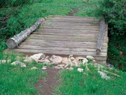
 From start to finish this three-mile descent drops approximately 1,000 feet and is heavily used by hikers and mountain bikers. Surprisingly the steeper upper part is the easiest. The first two stream crossings even have sturdy wooden bridges, and the next few crossings are a simple rock-hop across. At this altitude wild turkeys are not on my mind - but there they are at the very top of the trail moving toward the security of a deep wooded thicket. These birds have made a strong comeback from the brink of extinction and it is not unusual to see small flocks of them in the higher elevations. From start to finish this three-mile descent drops approximately 1,000 feet and is heavily used by hikers and mountain bikers. Surprisingly the steeper upper part is the easiest. The first two stream crossings even have sturdy wooden bridges, and the next few crossings are a simple rock-hop across. At this altitude wild turkeys are not on my mind - but there they are at the very top of the trail moving toward the security of a deep wooded thicket. These birds have made a strong comeback from the brink of extinction and it is not unusual to see small flocks of them in the higher elevations.
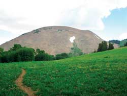
The two dominant peaks on the upper section of this trail are Haystack Mountain to the north and Mount Mellenthin to the south. Up through the tundra almost to the summit of Haystack, the outline of stunted trees gives this mountain a distinctive appearance.
 Mount Mellenthin, with its numerous lingering snowfields, is back-dropped by blackened, angry thunderheads. This massive mountain is named after Rudolph Mellenthin. Born in Germany in 1884, he, with his family, later immigrated to the United States where they gravitated to the West. It didn’t take long for Mellenthin to fall in love with that rugged lifestyle. To prove his loyalty to his adopted country he fervently wanted to join the U.S. army, and he was deeply disappointed when he wasn’t accepted for military service. Instead, on August 9, 1909, he settled for an assignment as a “forest guard” in the La Sal National Forest. Three years later he married and bought a home in Moab where he and his wife Blanche could raise their three sons. Mount Mellenthin, with its numerous lingering snowfields, is back-dropped by blackened, angry thunderheads. This massive mountain is named after Rudolph Mellenthin. Born in Germany in 1884, he, with his family, later immigrated to the United States where they gravitated to the West. It didn’t take long for Mellenthin to fall in love with that rugged lifestyle. To prove his loyalty to his adopted country he fervently wanted to join the U.S. army, and he was deeply disappointed when he wasn’t accepted for military service. Instead, on August 9, 1909, he settled for an assignment as a “forest guard” in the La Sal National Forest. Three years later he married and bought a home in Moab where he and his wife Blanche could raise their three sons.
Unfortunately, ranchers, used to a free rein in the La Sal Mountains, resented the intrusion of government restrictions. Mellenthin’s German accent and fanatical devotion to forest regulations earned him the nickname “Kaiser.”
In stark contrast to the passionately patriotic Mellenthin, Ramone Archuletta was an army deserter who had already escaped from two previous recaptures. Attempting to avoid detection, he traveled with his father-in-law, Ignacio Martinez, and another companion, Francesco Maestas, in the remote regions of southeast Utah to a sheep camp on Pine Bluff, a few miles north of La Sal. In July 1918, San Juan County sheriff Frank Barnes deputized Mellenthin to arrest Archuletta. Two of his friends went with him to investigate the outlaw’s camp. When Mellenthin ordered Archuletta to hand his rifle over to his father-in-law, the deserter began firing. Mortally wounded, Mellenthin still had the strength to draw his pistol to shoot Archuletta through the knee and hand.
Mellenthin’s friends ran for help and the posse arrived just a few minutes before he died. Both Archuletta and Martinez surrendered without a fight. Convicted of second-degree murder, Archuletta served just six years of his life sentence before being released on parole. Due to a lack of evidence, the Utah Supreme Court overturned Martinez’s sentence, and he became a free man in September 1920.
In giving up his life Mellenthin finally proved his fierce patriotic loyalty. In honor of that sacrifice, Mount Mellenthin bears his name.
After two miles the meadows finally run themselves out and the two peaks disappear from view. Now a fairly level grade follows the Mill Creek drainage, where there is the surging rush of waterfalls, dashing along in two adjacent creeks on a collision course that joins them together as one. Before the trail drops down to Clark’s Lake, it forks, and the upper trail continues on to the Geyser Pass Road. The lower trail travels above Clark’s Lake and then proceeds down to the last steep mile of descent to Oowah Lake, where your chariot awaits you.
|
Biological Soil Crust (aka)
Cryptos (krip’ tose):
The surface of
Moab’s desert is held
together by a thin skin of living organisms known as cryptobiotic
soil or cryptos. It has a lumpy black appearance, is very
fragile, and takes decades to heal when it has been damaged.
This soil is a critical part of the survival of the desert.
The cryptobiotic organisms help to stabilize the soil, hold
moisture, and provide protection for germination of the seeds
of other plants. Without it the dry areas of the west would
be much different. Although some disturbance is normal and
helps the soil to capture moisture, excessive disturbance
by hooves, bicycle tires and hiking boots has been shown
to destroy the cryptobiotic organisms and their contribution
to the soil. When you walk around Moab avoid crushing the
cryptos. Stay on trails, walk in washes, hop from stone to
stone. Whatever it takes, don’t crunch the cryptos
unless you absolutely have to! |
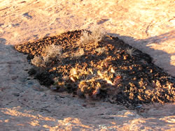
Cryptobiotic soil garden
|
|
|