HIKING HAPPENINGS
August 2009
Squaw Springs Trail – Back To The Mountains
by Marcia Hafner
 It doesn’t take long for the blistering desert heat to wear me down and my soul begs for relief. Fortunately it’s no secret that relief is less than an hour’s drive away. That’s all the time it takes to migrate 6,000 feet up to the La Sal Mountains - a gain in elevation that makes all the difference in the world, and every summer I’m back once again to enjoy cool, refreshing hikes on our nearby mountain trails. It doesn’t take long for the blistering desert heat to wear me down and my soul begs for relief. Fortunately it’s no secret that relief is less than an hour’s drive away. That’s all the time it takes to migrate 6,000 feet up to the La Sal Mountains - a gain in elevation that makes all the difference in the world, and every summer I’m back once again to enjoy cool, refreshing hikes on our nearby mountain trails.
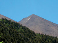
For thousands of years Native Americans made this seasonal upward migration. That influence is reflected in the naming of Tomasaki Peak and Mount Waas after two Ute leaders, a designation made by members of the Hayden survey crew in 1875. Tradition suggests that the translation of “Tukunikivatz” means place where the sun sets last – an appropriate term for one of the more prominent peaks in the La Sals.
Twenty-five to thirty million years ago, intrusive molten magma cooled into igneous rock. Then the overlying, less-resistant sandstone eroded away and resulted in the formation of the La Sal Mountains - a range that is 25 miles long (north-south) and 15 miles wide (east-west). The La Sals are the second highest range in Utah. With fourteen peaks (some of them unnamed) over 12,000 feet, they are divided into three distinct groups - north, middle and south. Mount Peale, the highest peak at 12,721 feet, was named after Albert Charles Peale, a geologist on the Hayden Survey team. There are two passes: La Sal Pass (10,125 feet) and Geyser Pass (10,500 feet). La Sal Pass divides the south group from the middle and Geyser Pass is between the middle and north. If you’re asking, Where’s the geyser?! It’s useful to know that there isn’t one. The pass is named after Al Geyser, an early cattleman.
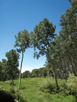
 I am fond of hiking the well-used and well-marked Squaw Springs Trail. Since it has a minimal increase in elevation, it is not a lung buster as it weaves in and out of a patchwork quilt of oaks, aspens and with short stretches of riparian conifer forest. During most of the hike Spanish Valley, Moab Valley, Brumley Ridge and the Henry Mountains on the far distant western horizon steadily pop in and out of view. The farther I go, the better the long distance vistas. At one spot you can actually pick out the well-known Moab landmarks such as Behind the Rocks, Hidden Valley, the Potash Mine, and Spanish Trail Arena. I am fond of hiking the well-used and well-marked Squaw Springs Trail. Since it has a minimal increase in elevation, it is not a lung buster as it weaves in and out of a patchwork quilt of oaks, aspens and with short stretches of riparian conifer forest. During most of the hike Spanish Valley, Moab Valley, Brumley Ridge and the Henry Mountains on the far distant western horizon steadily pop in and out of view. The farther I go, the better the long distance vistas. At one spot you can actually pick out the well-known Moab landmarks such as Behind the Rocks, Hidden Valley, the Potash Mine, and Spanish Trail Arena.
The trail begins on the Geyser Pass Road and ends approximately four miles later at the La Sal Pass Road. Traveling there via the La Sal Pass Road requires a high clearance four-wheel drive vehicle while the Geyser Pass Road is graded gravel. So make it easy on yourself and your vehicle and take the Geyser Pass Road.
To get to that trailhead from Moab go south on Highway 191 for approximately eight miles. Then turn left at the Ken’s Lake - La Sal Loop Road sign followed by a right at the dead-end, which becomes the La Sal Loop Road. After a big elevation gain, there will be a sign to turn right on to the Geyser Pass Road. Drive 3.1 more miles to the trailhead, which begins at the hairpin on the right side of the road.
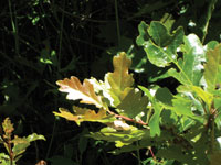
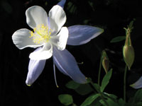 Along much of the trail abundant snowberry plants hang heavy with tiny bell-shaped creamy white blossoms. Early in the fall their snow-white berries are edible, but they taste like Ivory soap! In the shaded, moist areas I am delighted to find huge collections of the exquisite blue columbine swaying in a slow breeze-tossed dance. To me these delicate, uniquely designed flowers of varying shades of blue and creamy white are symbolic of the higher elevations. Commonly found growing in moist soils with lots of shade, it’s no mystery as to why the blue columbine, which is in the buttercup family, was chosen to be the state flower of Colorado. Along much of the trail abundant snowberry plants hang heavy with tiny bell-shaped creamy white blossoms. Early in the fall their snow-white berries are edible, but they taste like Ivory soap! In the shaded, moist areas I am delighted to find huge collections of the exquisite blue columbine swaying in a slow breeze-tossed dance. To me these delicate, uniquely designed flowers of varying shades of blue and creamy white are symbolic of the higher elevations. Commonly found growing in moist soils with lots of shade, it’s no mystery as to why the blue columbine, which is in the buttercup family, was chosen to be the state flower of Colorado.
Not far into the walk, there’s a dry crossing over a sweet little stream that is accompanied by the charming gurgle of a small waterfall. Just before dropping into the Brumley Creek drainage, you come to a grazing allotment fence with a sign “Please Close the Gate.” I eliminate that hassle by squeezing through the opening at the bottom for I know all too well these gates often require the strength of Hercules to open and close. The roar of Brumley Creek, which was named after the owner of a sawmill in Gold Basin, can be heard long before I get to it. The stream crossing requires either rock hopping or a careful walk over a log - I found the log-walk worked the best. Beware of stinging nettles, a tall plant with saw-tooth edged leaves that when touched, do sting because the stinging hairs, when disturbed, secrete formic acid.
 As I wander through the deep dark forest of conifers towards Dorry Creek, named for the pioneer sheepherder Dorry Crouse, the damp, cool air is filled with the delightful scent of pine. At the crossing I swing left and cross the two logs over the stagnant creek bed. Then to avoid muddy feet, I tiptoe gingerly over piles of logs that have been strategically placed over a messy bog. As I wander through the deep dark forest of conifers towards Dorry Creek, named for the pioneer sheepherder Dorry Crouse, the damp, cool air is filled with the delightful scent of pine. At the crossing I swing left and cross the two logs over the stagnant creek bed. Then to avoid muddy feet, I tiptoe gingerly over piles of logs that have been strategically placed over a messy bog.
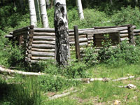
Climbing out of that drainage, the views change and South Mountain, Mount Tukunikivatz, Tuk No and the Abajo Mountains, a range on the southwestern horizon, come into sight. Shortly after that, I drop down to Squaw Springs, a treasured, romantic stop reminiscent of times gone by where the corral and roofless cabin still stand with a rusted bed frame languishing inside the dwelling. Pieces of metal and remnants of the cast iron stove are scattered on the ground completing the portrayal of a forgotten, serene way of life.
 Directly below the corral a stream gently trickles out of the spring and starts its journey through the lush green meadow beyond the cabin – a perfect pasture for an old timer’s livestock. The air vibrates with the sound of locust. A tiny warbling vireo sings his loud song. Ravens pass each other on their highway of pale blue sky having discussions known only to ravens. It is so cool and soothing I can’t resist a long break. So I stretch out in the luxurious shade of the whispering aspens pondering the lost history of where I am until finally I get my rear in gear for the final short stretch to the junction with the La Sal Pass Road. Directly below the corral a stream gently trickles out of the spring and starts its journey through the lush green meadow beyond the cabin – a perfect pasture for an old timer’s livestock. The air vibrates with the sound of locust. A tiny warbling vireo sings his loud song. Ravens pass each other on their highway of pale blue sky having discussions known only to ravens. It is so cool and soothing I can’t resist a long break. So I stretch out in the luxurious shade of the whispering aspens pondering the lost history of where I am until finally I get my rear in gear for the final short stretch to the junction with the La Sal Pass Road.
To make the most of everything the Squaw Springs Trail has to offer, plan on a full day so you can enjoy an unrushed sojourn into the refreshing summertime high of the La Sal Mountains.
|
Biological Soil Crust (aka)
Cryptos (krip’ tose):
The surface of
Moab’s desert is held
together by a thin skin of living organisms known as cryptobiotic
soil or cryptos. It has a lumpy black appearance, is very
fragile, and takes decades to heal when it has been damaged.
This soil is a critical part of the survival of the desert.
The cryptobiotic organisms help to stabilize the soil, hold
moisture, and provide protection for germination of the seeds
of other plants. Without it the dry areas of the west would
be much different. Although some disturbance is normal and
helps the soil to capture moisture, excessive disturbance
by hooves, bicycle tires and hiking boots has been shown
to destroy the cryptobiotic organisms and their contribution
to the soil. When you walk around Moab avoid crushing the
cryptos. Stay on trails, walk in washes, hop from stone to
stone. Whatever it takes, don’t crunch the cryptos
unless you absolutely have to! |
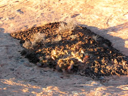
Cryptobiotic soil garden
|
|
|