HIKING HAPPENINGS August 2010
The Mountain View Trail – A View From The Other Side
by Marcy Hafner
 The La Sal Mountains were formed over twenty-five to thirty million years ago. At that time intrusive molten magma cooled into igneous rock and the overlying, less resistant sandstone eroded away, resulting in the formation of fourteen peaks over 12,000 feet. Covering an area in both San Juan and Grand Counties that is 25 miles long (north-south) by 15 miles wide (east-west), the La Sals are the second highest mountain range in Utah. Those of us lucky enough to live here are blessed to have these high altitude crown jewels in our backyard. Divided into three distinct groups - north, middle and south - this massive landmark with its distinctive profile dominates the horizon from both western Colorado and southeastern Utah, and whenever I’m on the road it’s my beacon signaling me that I am getting close to home. The La Sal Mountains were formed over twenty-five to thirty million years ago. At that time intrusive molten magma cooled into igneous rock and the overlying, less resistant sandstone eroded away, resulting in the formation of fourteen peaks over 12,000 feet. Covering an area in both San Juan and Grand Counties that is 25 miles long (north-south) by 15 miles wide (east-west), the La Sals are the second highest mountain range in Utah. Those of us lucky enough to live here are blessed to have these high altitude crown jewels in our backyard. Divided into three distinct groups - north, middle and south - this massive landmark with its distinctive profile dominates the horizon from both western Colorado and southeastern Utah, and whenever I’m on the road it’s my beacon signaling me that I am getting close to home.
We are very fortunate that the majority of this mountain range, this land of many uses for water, timber, grazing, minerals and recreation, is not privately owned. Instead, under the protection of the Manti La Sal National Forest, which was established in 1907, it remains open to the public where everyone has access to this delightful mountain wonderland. With a huge gain in elevation, residents and visitors alike seek this alpine refuge - especially in the summer to escape the baking desert heat, but also in the winter to cross-country ski and snowshoe.
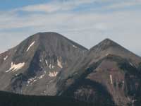
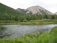 Warner Lake, at 9400 feet with its idyllic mountain scenery, which is dominated by Haystack Mountain, is an ideal place to pass a lazy afternoon. Close to the lake there’s a picnic area and a campground ($10.00 a night) with twenty sites, while the group camping area accommodates fifty people. The water in the campground, however, is not safe for drinking. Warner Lake, at 9400 feet with its idyllic mountain scenery, which is dominated by Haystack Mountain, is an ideal place to pass a lazy afternoon. Close to the lake there’s a picnic area and a campground ($10.00 a night) with twenty sites, while the group camping area accommodates fifty people. The water in the campground, however, is not safe for drinking.
It takes less than an hour to drive the estimated 35 miles to Warner Lake. To get there from Moab, go south on Highway 191 approximately 7.5 miles and turn left at the sign for the Ken’s Lake-La Sal Loop Road. Continue half a mile to the stop sign at the tee and turn right on to the Spanish Valley Drive-La Sal Loop Road. Go past the turn offs for Pack Creek Ranch, Geyser Pass Road and Oowah Lake. The next major road on your right after Oowah Lake will have a sign for Warner Lake.
This five-mile graveled road is suitable for any vehicle, but it is only open during the summer-early fall season. By late September-early October, depending on the weather, the possibility exists that the road will be closed for the winter.
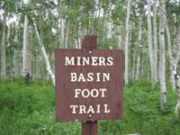
Warner Lake is the hub for a lot of trails; some are heavily used. I decide to take the less traveled Miners Basin Trail, which provides access to the Mountain View Trail. The signed trail begins at the information kiosk. Not far up the trail another sign has the following information: Miners Basin-Warner Trail #040, three miles to Miners Basin, Mountain View Trail #185 - .07 miles.
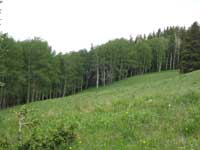
 This foot trail starts in the richness of dark blue lupines that flanks me on both sides. After two very easy open-and-close gates I take a right on to a dirt road and immediately look for the next sign with an arrow pointing for another right turn. Soon I’m following a wide switchback through the aspens to the trail register. Then the thick branches of Engelmann spruce and sub-alpine fir umbrella me in rippled shade where the mountain chickadees “dee-dee-dee” their trademark calls while red-breasted nuthatches “yank-yank-yank” a tinny trumpeted song that mingles with the enchanting fluted chorus of the hermit thrush. This foot trail starts in the richness of dark blue lupines that flanks me on both sides. After two very easy open-and-close gates I take a right on to a dirt road and immediately look for the next sign with an arrow pointing for another right turn. Soon I’m following a wide switchback through the aspens to the trail register. Then the thick branches of Engelmann spruce and sub-alpine fir umbrella me in rippled shade where the mountain chickadees “dee-dee-dee” their trademark calls while red-breasted nuthatches “yank-yank-yank” a tinny trumpeted song that mingles with the enchanting fluted chorus of the hermit thrush.
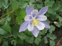 This steady uphill trail with its lovely bouquet of blue columbines, red columbines and bluebells clings next to the stream as it wanders past the sloping jumble of loose rock called scree. I easily tiptoe across the only stream crossing and when the firs and spruce give way to an aspen lined meadow, I am at a signed junction - right for the Mountain View Trail, left for the Miners Basin Trail. I go right to walk about a mile to the end of the trail. This steady uphill trail with its lovely bouquet of blue columbines, red columbines and bluebells clings next to the stream as it wanders past the sloping jumble of loose rock called scree. I easily tiptoe across the only stream crossing and when the firs and spruce give way to an aspen lined meadow, I am at a signed junction - right for the Mountain View Trail, left for the Miners Basin Trail. I go right to walk about a mile to the end of the trail.
Layered with pine needles, shredded bark and mangled cones, this path is cushy underneath my feet as I listen to the voices of a western tanager, juncos, pine siskins and a ruby-crowned kinglet. Well marked with rock cairns and notched trees this trail starts out along a small endearing stream that once again reminds me there’s nothing more soothing than the rhythmic beat of moving water. At one spot I pause to admire a miniature waterfall that drops into a small pool.
 Since this trail is on the shady, mossy north side of the mountain it collects excessive amounts of snow. With an above average snowfall this winter, sections of it stayed buried until the very end of June. In these deep woods of spruce and fir a plentitude of fallen trees adds to the dank mysterious mood. The flowers bloom late in the summer season, but sometimes in an open meadow where the sun breaks through there’s a big splash of color– the soft blue of the Jacob’s ladder with leaves patterned in the shape of a ladder along with the bright yellow of the golden pea and the nodding charm of the bluebell. Since this trail is on the shady, mossy north side of the mountain it collects excessive amounts of snow. With an above average snowfall this winter, sections of it stayed buried until the very end of June. In these deep woods of spruce and fir a plentitude of fallen trees adds to the dank mysterious mood. The flowers bloom late in the summer season, but sometimes in an open meadow where the sun breaks through there’s a big splash of color– the soft blue of the Jacob’s ladder with leaves patterned in the shape of a ladder along with the bright yellow of the golden pea and the nodding charm of the bluebell.
At one of those meadows it takes a few seconds for it to register what is moving behind that mule deer doe - her wobbly-legged, heavily spotted twins are no bigger than a medium-sized dog! She watches intently for any sign of danger so that she and her adorable fawns can safely wander off into the tall, thick green grass that completely hides the little ones.
As the trail climbs up from the stream towards the ridge I hear the jackhammer pounding of woodpeckers. I scan the dead trees and find two “three-toed woodpeckers” - a male sporting a yellow cap accompanied by a drabber looking female. Most woodpeckers have four toes - this rarely seen species has only three, which compromises the ability to climb but instead helps deliver a stronger forceful blow.
 The trail tops out at a meadow edged with aspens filled with parsley, yarrow, golden pea and larkspur. It ends shortly thereafter on a rock field of scree where a huge stone monument marks this astounding site of backside views of Mount Tukuhnikivatz, Tuk No, Mount Peale, pre-Laurel ridge with the weather station, Laurel Peak, Haystack Mountain, Mount Mellenthin, Tomasaki Peak and Manns Peak. On the western slope I look down on the steep cliffs of Mill Creek Canyon, Bald Mesa and the winding Loop Road. Down on the valley floor, the faint image of Moab appears, and beyond that are canyonlands stretching clear to the Henry Mountains on the far distant horizon. The trail tops out at a meadow edged with aspens filled with parsley, yarrow, golden pea and larkspur. It ends shortly thereafter on a rock field of scree where a huge stone monument marks this astounding site of backside views of Mount Tukuhnikivatz, Tuk No, Mount Peale, pre-Laurel ridge with the weather station, Laurel Peak, Haystack Mountain, Mount Mellenthin, Tomasaki Peak and Manns Peak. On the western slope I look down on the steep cliffs of Mill Creek Canyon, Bald Mesa and the winding Loop Road. Down on the valley floor, the faint image of Moab appears, and beyond that are canyonlands stretching clear to the Henry Mountains on the far distant horizon.
According to the map, this route is called Don’s Trail, but recent signage has renamed it Mountain View. The name fits the description well for it delivers the unusual views, the other side views, off the beaten path views. Until recently, I didn’t even know it existed. What a wonderful discovery to see these familiar mountains from an entirely different perspective.
|
Biological Soil Crust (aka)
Cryptos (krip’ tose):
The surface of
Moab’s desert is held
together by a thin skin of living organisms known as cryptobiotic
soil or cryptos. It has a lumpy black appearance, is very
fragile, and takes decades to heal when it has been damaged.
This soil is a critical part of the survival of the desert.
The cryptobiotic organisms help to stabilize the soil, hold
moisture, and provide protection for germination of the seeds
of other plants. Without it the dry areas of the west would
be much different. Although some disturbance is normal and
helps the soil to capture moisture, excessive disturbance
by hooves, bicycle tires and hiking boots has been shown
to destroy the cryptobiotic organisms and their contribution
to the soil. When you walk around Moab avoid crushing the
cryptos. Stay on trails, walk in washes, hop from stone to
stone. Whatever it takes, don’t crunch the cryptos
unless you absolutely have to! |

Cryptobiotic soil garden
|
|
|