HIKING HAPPENINGS November 2010
Seven-Mile Canyon – The North Fork
by Marcy Hafner
 It’s anyone’s guess as to how Seven Mile Canyon received its name, but maybe, just maybe, at one time it was estimated to be seven miles long when it reached its terminal point at the confluence of Courthouse Wash in Arches National Park. Beneath the well-known landmarks of Monitor and Merrimac Buttes, the eastern portion of Highway 313 travels along its extremely wide bottom before leaving the canyon when the switchbacks start up to Canyonlands National Park and Dead Horse Point State Park. It’s anyone’s guess as to how Seven Mile Canyon received its name, but maybe, just maybe, at one time it was estimated to be seven miles long when it reached its terminal point at the confluence of Courthouse Wash in Arches National Park. Beneath the well-known landmarks of Monitor and Merrimac Buttes, the eastern portion of Highway 313 travels along its extremely wide bottom before leaving the canyon when the switchbacks start up to Canyonlands National Park and Dead Horse Point State Park.
There are two major forks at the beginning of Seven Mile - the North Fork and the South Fork - and both of them are easily accessible from Highway 313. The North Fork, with its intriguing history and side canyons to explore, is a hiker’s delight that is a quick scenic drive from Moab. To get there, go north on Highway 191 for approximately nine miles and turn left on to Highway 313. Then drive three more miles and park at a pullout on the right just before the cattle guard. Pay attention – this pullout is easy to pass by!!
To make the descent, I climb over the sag in the metal fence and scramble down the rubble of rock that is piled up at the base of a huge culvert. An alternate route is to cross the highway and drop down via the culvert. No trail has been established through the wide girth of this canyon, but with the wash in this drainage so easy to walk in who needs a trail? An old dirt road, however, does extend through this canyon and traces of it can still be found.
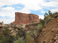
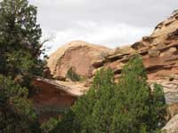
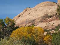 Kayenta Sandstone is the building block of these canyon walls. Exquisitely rounded and layered, they have a pleasing, gentle flow that creates an entirely different sensation from the awesome power of the sheer walls of Navajo and Wingate Sandstone. Kayenta Sandstone is the building block of these canyon walls. Exquisitely rounded and layered, they have a pleasing, gentle flow that creates an entirely different sensation from the awesome power of the sheer walls of Navajo and Wingate Sandstone.
The fast growing cottonwood trees like to keep their feet wet and in the dampness at the beginning of my walk they form a leafy tunnel. Strolling through the reedy water-loving grass, I am captivated by the impression of walking under a giant, lacy umbrella. At this nostalgic time of year the stirring of yellowing foliage constantly whispers that fall has taken command. Related to aspens and poplars, the saw toothed cottonwood leaves share the same enchanting ability to shake and sway with the breeze. Some leaves have already turned; others haven’t yet made that transition – green against yellow whispers that fall is just getting started.
The surface water quickly runs dry and the cottonwoods become more scattered until they are replaced by the juniper, sagebrush and rabbitbrush. The rabbitbrush in full bloom adds to my fallish mood. A recent rain has enhanced the sharp intense fragrance of the sagebrush and pinching off some foliage I breathe deeply to inhale that wonderful pungent scent. This toxic bitter tasting desert plant seems to suit the palate of the pronghorn antelope and they browse on it extensively. Native Americans found sagebrush useful as a dressing to treat infections, an antidote for internal bleeding and a cleansing tonic to expel internal parasites.
 Three-fourths of a mile into my walk, I swing right to explore a short side canyon and before long I am brought to an abrupt halt by a huge overhanging pour-off. After some internal debate, I spur myself up the steep trail to the left to the unexpected verdant growth of cottonwoods, thick grasses, skunkbush and oaks. Coming from the sparseness below, this is a pleasant surprise. Hemmed in by a short box canyon, however, it doesn’t take long before the walls close in. Unless I sprout wings and fly, this is the end of the line. Three-fourths of a mile into my walk, I swing right to explore a short side canyon and before long I am brought to an abrupt halt by a huge overhanging pour-off. After some internal debate, I spur myself up the steep trail to the left to the unexpected verdant growth of cottonwoods, thick grasses, skunkbush and oaks. Coming from the sparseness below, this is a pleasant surprise. Hemmed in by a short box canyon, however, it doesn’t take long before the walls close in. Unless I sprout wings and fly, this is the end of the line.
Returning to the main fork, I continue moseying along towards the mouth of the canyon. Dryness gradually turns to dampness and then to wetness until the underground seepage forms large pools. Ahead of me a huge cluster of cottonwoods is a clue that I’m getting close to the end and soon I’m in a runaway growth of six-foot tall grass, cottonwood, willow, Gambels oak and skunkbush. In the streambed recent flash flooding has flattened the reedy, leafless scouring rush all in the same direction making that vegetation look like a big layer of green knitting needles.
All of a sudden what I’m hoping to find angles up in front of me - a heavy steel cable that remains visible along the canyon wall all the way to the rim. I have read that this cable was used to haul supplies for the stockmen who were herding cattle in the pastures above the canyon.
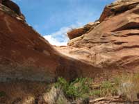 The pour-off at the mouth of the canyon is so tantalizingly close, but to make my way through this impenetrable jungle, I need a machete! If I had made the passage, I’d be looking for the trail to the left around the pour-off and the two wooden ladders that went from there straight to the top. Obviously a lot has happened since the placement of those two ladders and I suspect by now they are long gone. The pour-off at the mouth of the canyon is so tantalizingly close, but to make my way through this impenetrable jungle, I need a machete! If I had made the passage, I’d be looking for the trail to the left around the pour-off and the two wooden ladders that went from there straight to the top. Obviously a lot has happened since the placement of those two ladders and I suspect by now they are long gone.
On this perfect fall day the whole canyon has been empty and I find little impact from other hikers. But once upon a time, before the main highway made traveling quick and easy, it is obvious this route was traveled regularly through the North Fork and on up the rim – a feat that would quickly give me a severe case of vertigo!! I wonder what it must have been like back then during a more rustic era, when paved roads into these canyons didn’t exist and could only be imagined in an old timer’s daydreams.
|
Biological Soil Crust (aka)
Cryptos (krip’ tose):
The surface of
Moab’s desert is held
together by a thin skin of living organisms known as cryptobiotic
soil or cryptos. It has a lumpy black appearance, is very
fragile, and takes decades to heal when it has been damaged.
This soil is a critical part of the survival of the desert.
The cryptobiotic organisms help to stabilize the soil, hold
moisture, and provide protection for germination of the seeds
of other plants. Without it the dry areas of the west would
be much different. Although some disturbance is normal and
helps the soil to capture moisture, excessive disturbance
by hooves, bicycle tires and hiking boots has been shown
to destroy the cryptobiotic organisms and their contribution
to the soil. When you walk around Moab avoid crushing the
cryptos. Stay on trails, walk in washes, hop from stone to
stone. Whatever it takes, don’t crunch the cryptos
unless you absolutely have to! |

Cryptobiotic soil garden
|
|
|