HIKING HAPPENINGS August 2011
The Lake To Lake Link – Warner To Oowah
article and photos by Marcy Hafner
In the spring of 1933, during the grip of the Great Depression, a Civilian Conservation Corps camp, which employed almost 200 men, was established at the Warner Ranger Station. Franklin D. Roosevelt, desperate to get men back to work, proposed this five year public relief program to provide three million jobs for the conservation and development of natural resources in rural areas of the United States.
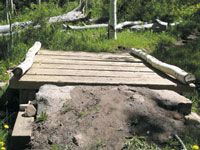
 In one season the laborers completed range improvements, overhauled trails and also constructed the stream-fed reservoirs of Medicine, Oowah and Clark, while making improvements on Warner, which was originally built as part of an irrigation system to Wilson Mesa. These projects, especially our beautiful alpine lakes, have now become an integral part of the La Sal Mountains. It’s hard to imagine all the strenuous work that went into their construction, and even harder to picture our high country landscape without them. In one season the laborers completed range improvements, overhauled trails and also constructed the stream-fed reservoirs of Medicine, Oowah and Clark, while making improvements on Warner, which was originally built as part of an irrigation system to Wilson Mesa. These projects, especially our beautiful alpine lakes, have now become an integral part of the La Sal Mountains. It’s hard to imagine all the strenuous work that went into their construction, and even harder to picture our high country landscape without them.
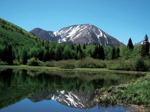
We are lucky to have visions of the La Sal Mountains on our eastern horizon year round, and even luckier during the scorching summer heat to have this delightful mountain oasis a short drive away - an upward migration of 6,000 feet or more miraculously drops the temperature down to an uplifting comfort zone of refrigerated coolness. When the thermometer in Moab is climbing past the century mark, Warner Lake, at an elevation of 9,350 feet, is an idyllic location to chill out - the reflection of Haystack Mountain on its refreshing blue waters a perfect cure for the summer time blues. Close by, there’s a picnic area, a campground with twenty sites ($10.00 per night) and a group campsite that accommodates fifty people.
To get to Warner Lake from Moab, drive almost eight miles south from the center of town on Highway 191 and turn left at the sign for the Ken’s Lake-La Sal Loop Road. Continue half a mile to the stop sign at the “T” and turn right on to the Spanish Valley Drive-La Sal Loop Road. Drive past the Geyser Pass and Oowah Lake turn-offs, and 12.7 miles from the “T” take a right at the sign for Warner Lake. Despite the often washboard condition, this five mile graveled road is suitable for any vehicle, but is only open during the summer and early fall seasons.
 This majestic mountain lake, a popular spot for fishermen, is a hub for six well-used trails. For my hike on the Oowah Lake Trail, I walk past the south side of the lake and at the first signed fork, I go right for the Oowah Lake-Schulman Gulch Trail rather than turning left on to the Burro Pass-Dry Fork Trail. At the next marked intersection, I take a left for the two mile route that will end at Oowah Lake. This majestic mountain lake, a popular spot for fishermen, is a hub for six well-used trails. For my hike on the Oowah Lake Trail, I walk past the south side of the lake and at the first signed fork, I go right for the Oowah Lake-Schulman Gulch Trail rather than turning left on to the Burro Pass-Dry Fork Trail. At the next marked intersection, I take a left for the two mile route that will end at Oowah Lake.
Gradually heading down in a southerly direction, I relish the pungent earthy scent of pine and the wonderful dance of the quaking aspen. The stronger the breeze, the faster those heart-shaped leaves move – there’s no better wind chime than their delightful rustle.
A variety of birds, protectively hidden in the denseness of firs and spruce, reveal their identity when they open their mouths to belt out their lively tunes. The most prominent and prolonged are the voices of the warbling vireos as these boisterous birds pour forth in song without ever seeming to take a deep breath. Occasionally, a ruby-crowned kinglet jumps in with his jumble of energetic notes. In this thick foliage I seldom see these constantly-in-motion dynamos, let alone catch a glimpse of the male’s brilliant red crown, which is usually concealed. From the tips of the trees, I hear the harsh rattling call of a Steller’s jay and as always, I am enchanted with the melodious flute-like chorus of the hermit thrush that carries so hauntingly from within the thicket of the lower level of the trees.
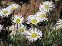
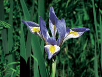
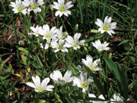
Walking through a wealth of wildflowers, I often pause to soak in their special beauty as I admire the charming nod of the bluebells, the petite size and loveliness of the creamy white to pale blue violets and the dazzling brilliance of the deep blue larkspur. In their preferred wetness zone, the mountain iris has been prolific this year. Bluish-purple, softly streaked with yellow, these flowers always deserve a close-up look.
In certain areas, the profuse glitter of the golden peas and dandelions – a cornucopia of gold - stuns my visual senses. Swallowtails and mourning cloak butterflies, which are intent on this blossoming bounty, languidly flutter from flower to flower to sip on this sweet cocktail of nectar. These uniquely marked winged beauties look so fragile, but as long as their habitat stays intact, as a species, these fascinating insects are inherently resilient.
At some of the stream crossings, recent snowmelt has overflowed their banks, and a normally dry trail is now transformed into a wet marshy bog - a slip-sliding quagmire of mud – something the large group of happy, playful kids behind me don’t mind at all! Further along, I am grateful for the wooden bridge that transports me over the rushing waters and most of the mud!
Once in awhile, the thick trees give way to a drier, wide-open slope, and when that happens the views are spectacular. I can’t pass up one particularly advantageous spot, and anxious to heave my heavy pack off my back, I plop down for a long break so I can appreciate this long distance setting. At this special moment on a crystal clear day, I am enjoying immensely this high altitud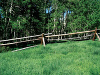 e interlude as I look down on a hot isolated landscape, which stretches for miles and miles across a tangled web of canyons, mesas and buttes – a wondrous scene that is climaxed on the western horizon with the sharply defined profile of the three separate sections of the Henry Mountains. e interlude as I look down on a hot isolated landscape, which stretches for miles and miles across a tangled web of canyons, mesas and buttes – a wondrous scene that is climaxed on the western horizon with the sharply defined profile of the three separate sections of the Henry Mountains.
Much later, I reluctantly push myself back up on my feet to move along on the last part of the trail, which abruptly drops down into the Mill Creek drainage. My knees feel the grueling 15% grade, as I jounce down on this rocky section to the Oowah Lake Road. Now the route, which continues on the road, mellows out as I walk the final uphill half-mile to the trailhead at the lake finishing a gratifying two mile high elevation hike.
|
Biological Soil Crust (aka)
Cryptos (krip’ tose):
The surface of
Moab’s desert is held
together by a thin skin of living organisms known as cryptobiotic
soil or cryptos. It has a lumpy black appearance, is very
fragile, and takes decades to heal when it has been damaged.
This soil is a critical part of the survival of the desert.
The cryptobiotic organisms help to stabilize the soil, hold
moisture, and provide protection for germination of the seeds
of other plants. Without it the dry areas of the west would
be much different. Although some disturbance is normal and
helps the soil to capture moisture, excessive disturbance
by hooves, bicycle tires and hiking boots has been shown
to destroy the cryptobiotic organisms and their contribution
to the soil. When you walk around Moab avoid crushing the
cryptos. Stay on trails, walk in washes, hop from stone to
stone. Whatever it takes, don’t crunch the cryptos
unless you absolutely have to! |

Cryptobiotic soil garden
|
|
|