HIKING HAPPENINGS APRIL 2012
Ken’s Lake Recreation Area – The Rock Loop Trail
article and photos by Marcy Hafner
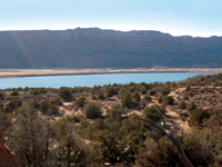
 Ken’s Lake, a man-made surprise, just happens to be located smack dab in the middle of a desert environment in Upper Spanish Valley. This body of deep blue water contrasts sharply against the surrounding arid landscape where only prickly pear, perennial grasses and other low-lying vegetation manage to survive. Ken’s Lake, a man-made surprise, just happens to be located smack dab in the middle of a desert environment in Upper Spanish Valley. This body of deep blue water contrasts sharply against the surrounding arid landscape where only prickly pear, perennial grasses and other low-lying vegetation manage to survive.
The water, which feeds this oasis, is diverted out of Mill Creek through Sheley Tunnel underneath Flat Pass. After that 645 foot course, it cascades over boulders and rock ledges on its route to Faux Falls followed by the final dash down a clear, fast moving stream to Ken’s Lake.
Around the beginning of the twentieth century Horace Sheley attempted to construct the tunnel, but was unsuccessful in boring through the entire length of sandstone. After that first attempt, the project languished for decades until the early 1970’s when a cycle of drought pressed the need for more water – a concern that triggered a renewed interest to investigate the possibility of completing the tunnel and building the reservoir. Finally, after years of planning, ground breaking began on October 4, 1979.
Ken McDougald, former mayor and water conservancy district chairman, labored for 15 years before this project was completed. Named in his honor, Ken’s Lake was dedicated on June 5, 1981 – an enterprise developed mainly for irrigation purposes in upper Spanish Valley, long known as Poverty Flats because of its serious lack of water. The 96 foot high earthen dam holds an estimated 2,610 acre feet of water, which allows for the cultivation of approximately 900 acres – an ambitious endeavour that cost four million dollars.
 The Utah Division of Wildlife stocks Ken’s Lake with brown and rainbow trout, who thrive in the maximum depth of 70 feet. Anglers, swimmers, ice skaters in the colder winters and non-motorized boaters flock to this placid place to enjoy a tranquil interlude. It’s also a great location to observe the migration of waterfowl, shorebirds and osprey. The Utah Division of Wildlife stocks Ken’s Lake with brown and rainbow trout, who thrive in the maximum depth of 70 feet. Anglers, swimmers, ice skaters in the colder winters and non-motorized boaters flock to this placid place to enjoy a tranquil interlude. It’s also a great location to observe the migration of waterfowl, shorebirds and osprey.
To get to Ken’s Lake from Moab go south on Highway 191 approximately 7.5 miles and turn left at the sign for the Ken’s Lake-La Sal Loop Road. Then continue to the stop sign and turn right. After driving about 1.4 miles, turn left on the Ken’s Lake-Flat Pass Road. The turnoff for the Ken’s Lake Campground is just beyond the entrance for the lake. Campers take note: drinking water is not available.
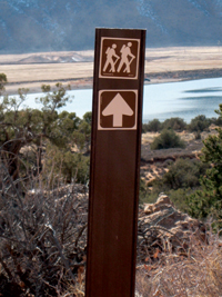
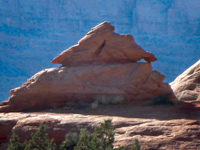
 The Ken’s Lake Recreation Area includes three trails - the Lake Loop, Faux Falls and the Rock Loop. More secluded and less crowded than the other two trails, the Rock Loop offers an interesting circle around a large outcrop of Navajo Sandstone called “The Rock.” Located on the east side of Ken’s Lake, portions of this one mile trail follow an old road, while also connecting with the Red Rock Horse Trail. The Ken’s Lake Recreation Area includes three trails - the Lake Loop, Faux Falls and the Rock Loop. More secluded and less crowded than the other two trails, the Rock Loop offers an interesting circle around a large outcrop of Navajo Sandstone called “The Rock.” Located on the east side of Ken’s Lake, portions of this one mile trail follow an old road, while also connecting with the Red Rock Horse Trail.
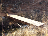
The trail begins across from campsite 25 and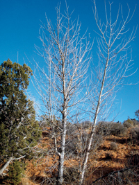 immediately drops down to a wooden bridge that crosses the fast moving stream that started its journey at Sheley’s Tunnel. On the western skyline the outline of Behind The Rocks presents a sawtoothed profile, while in the opposite direction South Mountain offers an alluring glimpse of snow-covered alpine scenery before disappearing from view. immediately drops down to a wooden bridge that crosses the fast moving stream that started its journey at Sheley’s Tunnel. On the western skyline the outline of Behind The Rocks presents a sawtoothed profile, while in the opposite direction South Mountain offers an alluring glimpse of snow-covered alpine scenery before disappearing from view.
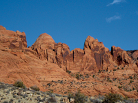
The dramatic scene on the eastern horizon rivets my attention to a stunning parade of sandstone structures, which travel in a north-south direction. If I could fly above them, I’d be looking down on Mill Creek. Piercing the baby-blue sky, they flank both sides of Flat Pass, while another section of sheer cliffs stretches up almost to the edge of Johnson’s Up On Top mesa. I stop often to study this massive concentration of giant-sized formations - gargantuan slabs of rocks, rocks and more rocks - a frenzy of wild contortions either tilted sideways, backwards or shooting straight up from the ground.
The weathered sign at the first junction is almost unreadable, but with The Rock as my guide, it is obvious I should go straight on the rock-lined trail, rather than right for Faux Falls, which is another great excursion. Except for one short stretch of sand on the upper end, this trail is well marked with rock cairns and signs.
 At the next fork I take a right for the counterclockwise route and continue my walk through the typical vegetation of junipers, pinyon pines, Mormon tea, blackbrush, Indian rice grass, saltbush and yucca. As I get closer to The Rock, several of its unique configurations stir my imagination - a flattened hat on a huge tilted block of rock - a gigantic snail with its head hanging out. At the next fork I take a right for the counterclockwise route and continue my walk through the typical vegetation of junipers, pinyon pines, Mormon tea, blackbrush, Indian rice grass, saltbush and yucca. As I get closer to The Rock, several of its unique configurations stir my imagination - a flattened hat on a huge tilted block of rock - a gigantic snail with its head hanging out.
 As I make the final swing around The Rock the views change, and now I capture a brief glimpse of the lake, which is harboring a flock of noisy Canada geese. After that I follow a wash down the west side until I finish the loop. As I make the final swing around The Rock the views change, and now I capture a brief glimpse of the lake, which is harboring a flock of noisy Canada geese. After that I follow a wash down the west side until I finish the loop.
On this wonderfully warm day, I stop for a cool refreshing break next to the creek. With the late afternoon sun softly caressing my face, I dreamily watch the wispy clouds traveling across the beautiful blue sky. An itsy-bitsy lizard scampering around the rocks has also responded to the sudden warmth, while a multitude of freshly hatched insects hover on fluttering wings above the water.
This riparian world is so soothing as the gurgling, crystal clear water bounces over the moss-covered rocks blocking out all other noises. As it glides through a small pool, the stream’s momentum is temporarily lost before making another mad dash to Ken’s Lake.
Always associated with wetness, the willows and cottonwoods cling close to the shore. On dryer ground the shaggy bark of a gnarled juniper reminds me of an old man - and old this tree must be for junipers live hundreds of years.
Enjoying this mesmerizing spot, I stay much longer than I should.
Finally I realize it really is time to go! But with such a short drive, I can easily return another day for the bird watching, the spectacular scenery, the hiking - or just to goof around.
|
Biological Soil Crust (aka)
Cryptos (krip’ tose):
The surface of
Moab’s desert is held
together by a thin skin of living organisms known as cryptobiotic
soil or cryptos. It has a lumpy black appearance, is very
fragile, and takes decades to heal when it has been damaged.
This soil is a critical part of the survival of the desert.
The cryptobiotic organisms help to stabilize the soil, hold
moisture, and provide protection for germination of the seeds
of other plants. Without it the dry areas of the west would
be much different. Although some disturbance is normal and
helps the soil to capture moisture, excessive disturbance
by hooves, bicycle tires and hiking boots has been shown
to destroy the cryptobiotic organisms and their contribution
to the soil. When you walk around Moab avoid crushing the
cryptos. Stay on trails, walk in washes, hop from stone to
stone. Whatever it takes, don’t crunch the cryptos
unless you absolutely have to! |

Cryptobiotic soil garden
|
|
|