HIKING HAPPENINGS July 2013
Hell’s Canyon Trail – A Long Way Down
by Marcy Hafner |
 Hell’s Canyon with its rugged, sharp-edged walls rightly deserves its name, as a scramble through its deep, brush-choked chasm would be a hellish passage. Fortunately, the trail follows the ridgeline that divides the Hell’s Canyon drainage from Pack Creek. Originally known as Pack Saddle Creek, this intermittent stream, which originates on the western slope of the La Sal Mountains, was named after two men fleeing from a band of Indians. In their haste to lighten their load, they left their packs along the creek. Hell’s Canyon with its rugged, sharp-edged walls rightly deserves its name, as a scramble through its deep, brush-choked chasm would be a hellish passage. Fortunately, the trail follows the ridgeline that divides the Hell’s Canyon drainage from Pack Creek. Originally known as Pack Saddle Creek, this intermittent stream, which originates on the western slope of the La Sal Mountains, was named after two men fleeing from a band of Indians. In their haste to lighten their load, they left their packs along the creek.
Creeping along on the rubbly-rock surface of the La Sal Pass Road – a bumpy, bone-rattling ride – we are en route to the upper entrance of the Hell’s Canyon Trail. As we slowly move along, the big drop-off just outside my window is making me very nervous. On this long narrow portion of our jolting keep-you-wide-awake drive, I am relieved that we do not meet any oncoming vehicles - backing up on this one-way road would be a logistical nightmare!
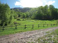 After bouncing along at a snail’s pace for 5.5 tedious miles, we finally arrive at the Squaw Springs trailhead; the sudden lack of momentum feels amazingly good. At last we’re back to the high country and the pine-scented air is cool and refreshing as I stretch to work out the kinks in my stiffened body. Summer has finally blossomed in the La Sal Mountains and I savor once again the rhythmic sway of the aspen leaves, the lush green meadow protected by a rail fence and the soothing trickle of a nearby stream. After bouncing along at a snail’s pace for 5.5 tedious miles, we finally arrive at the Squaw Springs trailhead; the sudden lack of momentum feels amazingly good. At last we’re back to the high country and the pine-scented air is cool and refreshing as I stretch to work out the kinks in my stiffened body. Summer has finally blossomed in the La Sal Mountains and I savor once again the rhythmic sway of the aspen leaves, the lush green meadow protected by a rail fence and the soothing trickle of a nearby stream.
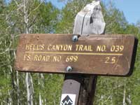
For a long time I’ve wanted to hike the entire length of the Hell’s Canyon Trail, and with my husband running the shuttle, that opportunity has arrived. A sign a short distance up the road marks the beginning of my long journey, a four mile hike that culminates in a dramatic drop in elevation to the desert floor.
 At 8600 feet, I begin my strenuous uphill climb along the ridgeline to the highest point on the trail. At this elevation the alpine country is advertising its special attractions – boggy stream crossings –wild roses that thickly flank the trail - yellow blooms of the golden pea - groves of aspens - the remarkable repertoires of the warbling vireos - tiny shy violets - and the nodding charm of bluebells. At 8600 feet, I begin my strenuous uphill climb along the ridgeline to the highest point on the trail. At this elevation the alpine country is advertising its special attractions – boggy stream crossings –wild roses that thickly flank the trail - yellow blooms of the golden pea - groves of aspens - the remarkable repertoires of the warbling vireos - tiny shy violets - and the nodding charm of bluebells.
Crawling under a log, I press onward as the steep climb continues. Gradually the dense vegetation gives way to wide-open meadows filled with dandelions, where sassy Steller’s jays are darting around.
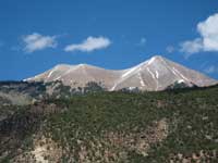
Finally I top out at 9,130 feet! By then I am breathing hard and more than ready for the downward portion, where at a fork I stay on “Trail 029,” following the sign that indicates the more difficult mountain biking route.
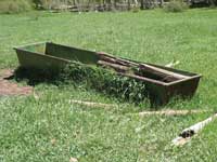 Soon, a cool carpet of green with a watering trough and great views of Mount Tukuhnikivatz and Tuk N are too appealing to pass up and so I linger. It’s been a long wait since last summer and I am delighted to see the aspens come alive again. Comfortably stretched out on the grass in this lovely meadow, I cherish a long break that enables me to absorb those oval leaves charismatically dancing against an incredibly blue sky while listening to their breeze-tossed rustle, nature’s wind chime that never gets too loud. Soon, a cool carpet of green with a watering trough and great views of Mount Tukuhnikivatz and Tuk N are too appealing to pass up and so I linger. It’s been a long wait since last summer and I am delighted to see the aspens come alive again. Comfortably stretched out on the grass in this lovely meadow, I cherish a long break that enables me to absorb those oval leaves charismatically dancing against an incredibly blue sky while listening to their breeze-tossed rustle, nature’s wind chime that never gets too loud.
Eventually I push myself up for the continuation of the long trek down. The further on I go, the more incredible the long distance views – Spanish Valley, the inviting greenness of the pastures surrounding upper and lower Pack Creek, the sheer jagged skyline of Behind The Rocks, miles and miles of canyonlands followed by the far distant Henry Mountains and the Bookcliffs.
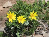
 Gradually leaving the aspens, I enter a thick forest of oaks, which are just barely leafing out. Before long, in the open areas where the green grass grows, an enchantingly lush cornucopia of flowers with a wealth of brilliant colors envelops me: purple larkspur, brilliant red Indian paintbrush, blue flax, blue pentstemon, tiny white cutleaf daisies, the bright yellow daisy-like balsamroot and Colorado loco, which is a magenta colored flower in the bean family. Flowers attract hummingbirds and a male broad-tailed hummer buzzes by so close he almost gives me a haircut! Gradually leaving the aspens, I enter a thick forest of oaks, which are just barely leafing out. Before long, in the open areas where the green grass grows, an enchantingly lush cornucopia of flowers with a wealth of brilliant colors envelops me: purple larkspur, brilliant red Indian paintbrush, blue flax, blue pentstemon, tiny white cutleaf daisies, the bright yellow daisy-like balsamroot and Colorado loco, which is a magenta colored flower in the bean family. Flowers attract hummingbirds and a male broad-tailed hummer buzzes by so close he almost gives me a haircut!
When I reach the pinyons and junipers, the trail becomes very steep – slide-out-from-under-your feet steep! How can mountain bike riders possibly do this? Constantly slamming on the brakes, I struggle to stay upright and only tumble three times, which I considered not too shabby considering the loose marbles I’m walking on! At a downed tree, I throw my pack and walking stick over and then heave myself up and over.
Needing a distraction, I don’t mind pausing now and then to listen to the melancholy chant of the mourning dove and the trumpety call of the red-breasted nuthatch. The bird watching prize for the day, however, goes to a dazzling male western tanager with his iridescent red head and striking black and yellow body. He and his lady friend, clad mostly in yellow, are engaged in a steady conversation.
As the day warms up, this downhill with its wide-sweeping switchbacks seems to go on forever, but at an elevation of 6,900 feet I have finally bottomed out! In approximately four miles, I have ascended 530 feet and descended 2,230 feet!
My ride is waiting and gratefully I hop in. After that tremendous workout sitting down on a cushy seat feels so good and pulling boots off my battered, smoking feet is divine! Driving out, we’re once again traveling on a rough route for several miles until it ends at the road through Pack Creek Ranch, where we now have smooth-sailing all the way home.
| To get to the La Sal Pass Road from Moab, go south on Highway 191 for approximately eight miles and then turn left at the Ken’s Lake-La Sal Loop Road sign. At the dead-end, turn right and drive approximately six more miles to the turn off for Pack Creek Ranch. The next three potholed miles to the picnic area are suitable for any vehicle, but after that for the 5.5 miles to the Squaw Springs trailhead, the La Sal Pass Road is a serious high-clearance, four-wheel drive route. |
|
Biological Soil Crust (aka)
Cryptos (krip’ tose):
The surface of
Moab’s desert is held
together by a thin skin of living organisms known as cryptobiotic
soil or cryptos. It has a lumpy black appearance, is very
fragile, and takes decades to heal when it has been damaged.
This soil is a critical part of the survival of the desert.
The cryptobiotic organisms help to stabilize the soil, hold
moisture, and provide protection for germination of the seeds
of other plants. Without it the dry areas of the west would
be much different. Although some disturbance is normal and
helps the soil to capture moisture, excessive disturbance
by hooves, bicycle tires and hiking boots has been shown
to destroy the cryptobiotic organisms and their contribution
to the soil. When you walk around Moab avoid crushing the
cryptos. Stay on trails, walk in washes, hop from stone to
stone. Whatever it takes, don’t crunch the cryptos
unless you absolutely have to! |
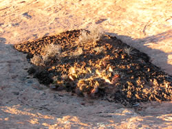
Cryptobiotic soil garden
|
|
|