In upper Gold Basin, beneath the lofty peaks of Tukuhnikivatz, Tuk No and Laurel, a heartbeat of water is born. Brumley is an elusive, intermittent stream; sometimes you see it, sometimes you don’t. During the full flush of spring runoff, it’s a crazy fool lover surging on a crash course to join up with Pack Creek. After that huge fling its fluctuating throb has a tendency to mysteriously disappear. Later in the summer when it crosses the Squaw Springs Trail, it is usually shyly tucked away underground, but then a short distance further it abruptly re-emerges in a thunderous surge as it tumbles down a crack in a huge rock wall that is popular with climbers.
 By the time its unpredictable flow has reached the pinyon-juniper country, it hunkers down again just barely below the surface where enough moisture sustains a wealth of water loving plants and trees. But whenever we are blessed with an abundance of rain, this reticent stream once again crawls out from under and bounteously runneth over.
Since the snow has started to fly in the mountains, the time has come to move my hiking agenda down to lower elevations. Starting at approximately 7,000 feet, a walk down to Brumley Creek is the perfect location for that transition.
To get there I head south out of town on Highway 191 for approximately eight miles and turn left at the sign for the Ken’s Lake-La Sal Loop Road. At the stop sign I turn right on to Spanish Valley Drive, which quickly becomes the La Sal Loop Road. Then I drive nine more miles and shortly after mile marker 15 I hang a right on to a jeep road and after a short but abrupt drop, I park, grab my pack and cautiously step over the bright yellow cattle guard.
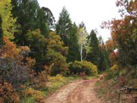
 Once my feet are firmly planted on the other side, I start my hike on a smooth going descent through the pinyon pines and junipers. Even though I’m barely hitting my stride I can’t resist stopping to give my full concentration to a wide screen, three-dimensional view - a tangled web of mesas, plateaus and canyons - an expansive landscape that stretches for miles and miles before bumping up against the horizontal silhouette of the Henry Mountains and the Abajos – a far reaching scene that never ceases to astound me.
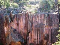
Then a mile further down the road I reach another awesome overlook above the Brumley-Dorry confluence. Here I ever so cautiously walk along the edge of a huge precipice above plummeting walls of sandstone which deceivingly look as smooth as polished marble crayoned over with varying hues of brown, black, yellow and gray. From the creek’s nourishing bottom Douglas firs shoot up straight and tall, while on top prickly pear cactus precariously cling to the edge.
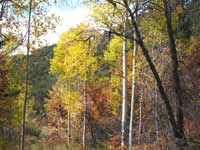 Suddenly I’m stepping back, this on-the-edge cliffside balcony is making me very nervous! It’s time anyway to mosey on and before long, passing through a rail fence with a wide-open gate, I arrive at the dry creek channel where the gentle descent bottoms out. Pulled in by the spell of a riparian paradise filled with the murmurings of fall, I savor the musky cidery fragrance – the flaming oaks – the golden aspen leaves fluttering in the breeze – the changing colors of the box elders - the crackling leaf-crunch underfoot – and the tiny streamside meadows covered with a fresh coating of fallen leaves.
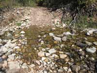
Then walking 1.3 miles I pass by a seldom-used, easy-to-miss crossing over Brumley’s dry belly. At this point a different jeep trail commences an interesting loop route up the ridge to a few deserted uranium mines. I proceed straight ahead on the more obvious track, and before long the underground water magically pops up to the surface with a gurgling purr; there a series of miniature cliffs bunched up beside the road present an intriguing setting, especially when there’s a chipmunk on top munching away on some tasty tidbit.
 Upon covering a distance of 2.5 miles, I reach a major junction and go right, where leap-frogging over some rocks gets me to the other side of the stream. By now the hour of noon is beckoning me to stop for lunch, and a bank above the creek provides that perfect opportunity. Oh how luxurious it feels to sit down, kick back and do absolutely nothing except bask in the warmth of the sun - absorb the crystal clear water prancing down a course of tiny waterfalls - watch the golden aspen leaves beating their own steady rhythm against the cerulean blue sky – and observe an industrious northern flicker hammering on the trunk of a tree.
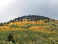
After that long, refreshing pause I continue up the road, which has been overtaken by an exuberant growth of oaks. With little room to spare I wiggle around several big puddles. From here I can peer down on the Brumley drainage from whence I just came and look up at the spectacular alpine presence of Mount Tukuhnikivatz and Tuk No flanked expansively in the foothills by the full blown autumnal plumage of oaks and aspens.
 At the crest there’s a road on the left that is not on the map. Now, curiosity overtakes me and I embark on a mission to discover where it goes. Immediately, an easy to open gate is followed by an uphill grind on a rubbly rock road. Determinedly I keep trudging along through a land dominated mainly by pinyons, wondering all the while, where can I possibly be going?
Eventually the pinyons peter out and ensconced in a solid grove of oaks, I hear the haunting bugle of an elk! When the road suddenly disappears in a scooped out meadow, I can’t resist the urge to proceed a little further to an enticing grove of glowing aspens. Upon reaching them, there at an elevation of 9,000 feet, I am immensely surprised to be standing on the Squaw Springs Trail! Wow! From start to finish I’ve gained a whopping 2,000 feet in elevation - no wonder I’m feeling so breathless! But it’s all been worthwhile - now I know where this uncharted road goes!