Let It Rain |
|
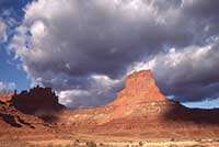 Rainstorms. Lightning. Thunder. Deluge. Drizzle. There may be 180 different words or phrases for snow and ice in the Inuit language, but in the desert, there are an equal number of words that describes the rarity of rain. No one says “Hey, it’s raining today.” The indigenous local population separates rain into “male” and “female” types. You can imagine male rain – thunderstorms and downpours versus the gentle, caressing, sweet female rains. Rainstorms. Lightning. Thunder. Deluge. Drizzle. There may be 180 different words or phrases for snow and ice in the Inuit language, but in the desert, there are an equal number of words that describes the rarity of rain. No one says “Hey, it’s raining today.” The indigenous local population separates rain into “male” and “female” types. You can imagine male rain – thunderstorms and downpours versus the gentle, caressing, sweet female rains. Though August may seem like an unlikely month for the monsoon season to peak, it represents the second wettest month of the year trailing only October. But August represents a month of greater extremes, where daily highs temperatures average close to 96°F daily, but also average 0.9” of rain about one-tenth of the annual average rainfall.  As storms roll up from the Southwest off of the Pacific Ocean, moisture is carried inland over the desert. As the air heats and rises, the water vapor begins to condense at higher elevations and form clouds. Cumulus clouds, those white, fluffy puffballs that parade across the area, are the typical summer cloud. As these cumulus clouds gain in elevation their shape changes to a cauliflower-like head with a dark underbelly. Now known as cumulonimbus clouds, these are the thunderheads that may be only a 1000’ above the ground but tower up to 40,000’ above the Earth. As storms roll up from the Southwest off of the Pacific Ocean, moisture is carried inland over the desert. As the air heats and rises, the water vapor begins to condense at higher elevations and form clouds. Cumulus clouds, those white, fluffy puffballs that parade across the area, are the typical summer cloud. As these cumulus clouds gain in elevation their shape changes to a cauliflower-like head with a dark underbelly. Now known as cumulonimbus clouds, these are the thunderheads that may be only a 1000’ above the ground but tower up to 40,000’ above the Earth.Energy released from the condensation of the water vapor transfers into lightning and thunder and the possibility of a downpour. These same clouds can create tornadoes, but in Utah this is a very rare event. The typical summer day weather forecast is something like this – chance of afternoon showers, clearing in the evening. Mornings tend to be cool and clear, but as the temperature rises so does the moisture in the air, what little there is of it. 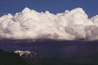 One year I was a fee collector at Natural Bridges National Monument, west of Blanding. The slowness of the day was punctuated by afternoon thunderstorms that would build up on the west edge of Elk Ridge before they recycled over the park. I had a front row seat to the buildup and could have shot time lapse photos showing the transformation from blue sky to towering thunderheads. When the clouds would let loose with a torrential downpour I was always jealous. Trapped in the fee booth, I wanted to drive out to the Kachina or Sipapu overlooks and watch as chocolate brown floods roared down the canyons. Literally, just add water and you have instant flash flood. One year I was a fee collector at Natural Bridges National Monument, west of Blanding. The slowness of the day was punctuated by afternoon thunderstorms that would build up on the west edge of Elk Ridge before they recycled over the park. I had a front row seat to the buildup and could have shot time lapse photos showing the transformation from blue sky to towering thunderheads. When the clouds would let loose with a torrential downpour I was always jealous. Trapped in the fee booth, I wanted to drive out to the Kachina or Sipapu overlooks and watch as chocolate brown floods roared down the canyons. Literally, just add water and you have instant flash flood. The storm’s duration determined the extent of flooding. After some storms White Creek barely rose and a few waterfalls cascaded off of the cliffs. Other days, the creek went bank to bank with a foaming and churning mass of water bullying its way down through the canyon. Waterfalls sluiced off the canyon walls, a truly remarkable site. Of course, this article is not meant to scare folks away from visiting the area in August. The message is to be aware, watch the sky for thunderhead formations, get down off the high points when lightning strikes, appreciate the floods and waterfalls, and enjoy the ephemeral aerial landscape that floats above the Canyon Country and rivals its earthly counterpart.
|