Trail Happenings February 2010
Jewel Tibbetts Arch Hiking Trail
by Katy Stevens
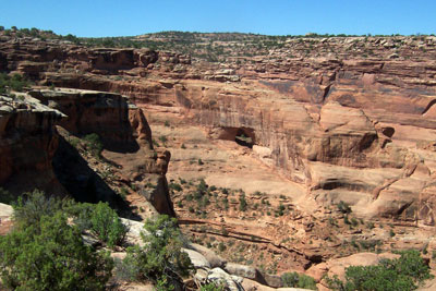 There is a spectacular arch at the head of Hell Roaring Canyon, just a few miles from busy Utah Highway 313. Despite its proximity to the highway, relatively few people have visited this treasure. In 2009, the Moab Office of the Bureau of Land Management developed a trailhead and finished marking a two mile hiking loop to highlight this beautiful natural feature. There is a spectacular arch at the head of Hell Roaring Canyon, just a few miles from busy Utah Highway 313. Despite its proximity to the highway, relatively few people have visited this treasure. In 2009, the Moab Office of the Bureau of Land Management developed a trailhead and finished marking a two mile hiking loop to highlight this beautiful natural feature.
The arch is named in honor of Jewel Tibbetts, a Moab-area woman who lived at the nearby Horsethief Ranch in the 1950’s and 1960’s with her husband, Bill Tibbetts. Jewel was originally from Oklahoma and moved to Moab in the early 1920’s. Ray Tibbetts, who lives in Moab, is the youngest of their 4 sons. The Tibbetts’ often took ranch visitors to see the arch at the head of Hell Roaring Canyon. Jewel told visitors that this arch was the prettiest arch that she had ever seen.
The arch overlooks Hell Roaring Canyon. The canyon is about 12 miles in length and flows into the Green River with a 400 foot drop-off at the arch overlook. The Hell Roaring Canyon does not have permanent water for most of the year, but it floods during severe rainstorms. These flashfloods carry a tremendous volume of water to the Green River. The canyon was formed through the endless forces of erosion, including the flooding that repeatedly scoured the canyon over the ages. Hell Roaring Canyon cuts through several layers of sandstone as it descends toward the Green River. The hiking trail is largely on the Kayenta Formation, which has relatively flat surfaces. The cliff face with the arch is from the Wingate Sandstone formation. The sandstone layers of Hell Roaring Canyon have been exposed by the forces of water and wind, creating this fantastic scenery.
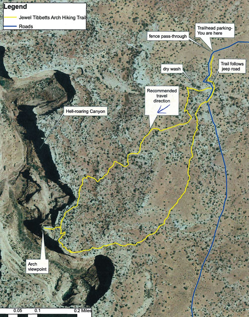
Access: Drive nine miles north of Moab, and turn west onto Utah Highway 313, towards Dead Horse Point State Park. Continue approximately 9.5 miles on Highway 313. Turn right on a dirt road which is located just prior to a cattle guard and fence. There is a small BLM sign at the road junction; “Jewel Tibbetts Arch 1.3 miles”. Proceed down the dirt road following the arrows at route intersections to get to the parking area and bulletin board. This dirt road may require some vehicular clearance – those without higher clearance vehicles may wish to park near Highway 313 and walk to the trailhead.
The Jewel Tibbetts Arch hiking trail makes a loop which begins at the parking area. The entire loop trail is about 2 miles in length and is fairly easy with a few minor obstacles. The trail starts on the road for the first hundred yards to a fence pass-through on the left of the bulletin board. Then walk south down the road until a sign directs you west (right) into a dry wash. You will be in the wash only a short distance before exiting on the left. (The recommended direction of travel is to walk the loop counter-clockwise.) The hiking trail combines wash walking with a cross country route including walking across rock ledges until you reach the rim of the curiously-named Hell Roaring Canyon.
The hiking trail is marked by cairns (small stacked piles of rocks) and arrows. As you get closer to the rim of Hell Roaring Canyon, be careful of steep drop-offs, especially at the arch viewpoint itself. Enjoy the view of this spectacular arch as well as the views into Hell Roaring Canyon. Continue the loop by following the marked trail up the hill behind the arch viewing area. The loop returns to the parking area on a higher ridge and affords views of the surrounding area. Alternately, hikers may retrace their steps from the arch viewing area to the parking area.
Hiking Safety Tips: Although the Jewel Tibbetts Arch Hiking Trail is a fairly easy two-mile walk, some simple concepts will ensure a safe trip:
• Bring plenty of water, especially in summer (at least 2 quarts)
• Wear a hat and use sunscreen
• Follow the route markings. If you lose track of them, return to the last marker and look hard for the next one. Look for the stacked piles of rocks called “cairns”.
• Expect uneven ground but fairly easy walking .
• Cliff Edges. Keep track of children. There are no guard railings at the arch viewpoint.
Jewel Tibbetts Arch makes a wonderful excursion on its own. The hike can also be combined with a trip to Dead Horse Point State Park or to Canyonlands National Park. There are many wonderful sights to see along Utah Highway 313, the Dead Horse Mesa Scenic Byway.
 Katie Stevens, the Outdoor Recreation Planner for the BLM is a member of Trail Mix, representing the BLM at our monthly meetings. The Bureau of Land Management is an integral part of the government entities that help form the committee.
Trail Mix is the Grand County advisory Committee representing non motorized trail users, (hikers, bikers, skiers and equestrians) in developing and maintaining a variety of trails throughout Grand County. Everyone is invited to our meetings held the second Tuesday of each month at the Grand Center from 12-2:00.
 There are many opportunities to volunteer to help with trail work. Contact Sandy Freethey sngmoab@preciscom.net 259-0253 or moabtrailmixinfo@gmail.com. For more volunteer information visit the Trail Mix website at www.grandcountyutah.net/trailmix/. |
|