Trail Happenings December 2011
Amasa Back - A Winter Destination
by Kirstin Peterson
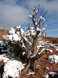 Winter in Moab. This thought conjures up images of solitude on the slickrock, exploring without the crowds of tourist season, and a light dusting of snow on the higher slopes of the red rock canyons. But often the light dusting is actually 6-12” of persistent snow that foils many a mountain bike or hiking adventure and steers many to the skiing opportunities in the La Sal Mountains. What many locals have discovered is that Moab has a nearby classic trail with a south facing orientation, making it snow-free earlier than any other spot plus offering an amazing array of riding and hiking opportunities – the Amasa Back trail. Winter in Moab. This thought conjures up images of solitude on the slickrock, exploring without the crowds of tourist season, and a light dusting of snow on the higher slopes of the red rock canyons. But often the light dusting is actually 6-12” of persistent snow that foils many a mountain bike or hiking adventure and steers many to the skiing opportunities in the La Sal Mountains. What many locals have discovered is that Moab has a nearby classic trail with a south facing orientation, making it snow-free earlier than any other spot plus offering an amazing array of riding and hiking opportunities – the Amasa Back trail.
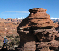 Amasa Back is a raised point of land that juts out of the Kane Creek Canyon area and is bordered on three sides by the Colorado River. Named after Amasa Larsen, a colorful local character who ran cattle in the area, Amasa Back is a multiple-use area that offers great opportunities for the mountain biker and hiker as well as the motorized recreationist. Often you’ll encounter all of these users happily sharing the trail and enjoying their own day out in this spectacular setting. The trail and terrain is by no means easy as there are ledges to navigate and steep sections to climb and descend, but the rewards are worth the effort. The views from the high overlooks are world class whether gazing out at the Jackson Hole monolith, looking across the Colorado River at Poison Amasa Back is a raised point of land that juts out of the Kane Creek Canyon area and is bordered on three sides by the Colorado River. Named after Amasa Larsen, a colorful local character who ran cattle in the area, Amasa Back is a multiple-use area that offers great opportunities for the mountain biker and hiker as well as the motorized recreationist. Often you’ll encounter all of these users happily sharing the trail and enjoying their own day out in this spectacular setting. The trail and terrain is by no means easy as there are ledges to navigate and steep sections to climb and descend, but the rewards are worth the effort. The views from the high overlooks are world class whether gazing out at the Jackson Hole monolith, looking across the Colorado River at Poison 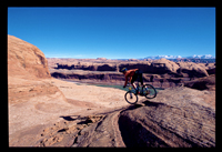 Spider Mesa, or searching for the Island in the Sky plateau and Dead Horse Point. Additional non-motorized routes off the main trail give mountain bikers fantastic singletrack options and range from a fun intermediate trail from the top to Pothole Arch to the extremely challenging Rock Stacker and Jackson Trails. These are great hiking routes as well which contour and drop through the cliffs overlooking the river and can be done alone or as a loop when combined with the jeep trail. Spider Mesa, or searching for the Island in the Sky plateau and Dead Horse Point. Additional non-motorized routes off the main trail give mountain bikers fantastic singletrack options and range from a fun intermediate trail from the top to Pothole Arch to the extremely challenging Rock Stacker and Jackson Trails. These are great hiking routes as well which contour and drop through the cliffs overlooking the river and can be done alone or as a loop when combined with the jeep trail.
To find the trailhead, either ride or drive from town on Kane Creek Road to the end of the pavement (4.5 miles) and park in one of two parking lots, the first on the right lies at the bottom of the Jackson Trail and the second is a half mile further, also on the right. The trailhead is another half mile up the road and is well signed. The trail itself immediately drops down towards the creek below. Often the creek has almost no water but occasionally the hiker needs to be inventive or barefooted!
Mileage on the trail will depend on what variation you decide on. Mountain bikers should plan on 3 hours to ride to the top 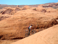 overlooking the Potash mine and back. A 5-6 hour variation adds the extra mileage of the challenging route to Pothole Arch and the option of the Rock Stacker and Jackson Trails. Plan to pick up a map at one of the bike shops in town and talk to staff about the difficulty of these trails to make sure this is the ride for you before heading out. overlooking the Potash mine and back. A 5-6 hour variation adds the extra mileage of the challenging route to Pothole Arch and the option of the Rock Stacker and Jackson Trails. Plan to pick up a map at one of the bike shops in town and talk to staff about the difficulty of these trails to make sure this is the ride for you before heading out.
Hikers can explore side canyons and with a careful eye will spot some of the rock art panels along the route as well as on the road approach to the trail. One favorite route is to hike up the jeep trail and back down the Jackson Trail which is a 6 mile loop although the Jackson Trail portion may be snowy for part of the winter due to its north facing slopes.
| The author, Kirstin Peterson, is the co-owner of Rim Mountain Bike Tours and an avid outdoors person. She has been active with Trail Mix and MTA since each organization was first started. |
 Trail Mix This committee represents non motorized trail users including: bikers, hikers, equestrians, and skiers. Many government agencies and private citizens comprise the “mix” that makes this group work so well. We meet the 2nd Tues. of each month from 12-2 at the Grand Center (500W. 182 N.). Everyone is welcome. Trail Mix This committee represents non motorized trail users including: bikers, hikers, equestrians, and skiers. Many government agencies and private citizens comprise the “mix” that makes this group work so well. We meet the 2nd Tues. of each month from 12-2 at the Grand Center (500W. 182 N.). Everyone is welcome.
Contact Sandy Freethey 259-0253 or find us online: wwwgrandcountyutah.net/trailmix/ or at moabtrailmixinfo@gmail.com.
|
|