|
|
TRAIL HAPPENINGS FEBRUARY 2012
Fisher Towers
by Dave Erley
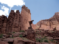
The Fisher Towers Trail is an intermediate hiking trail that has been designated by the Secretary of the Interior as a National Recreation Trail. This popular trail features towering red sandstone pinnacles in purple and red hues surrounded by stunning scenery in every direction. The trail is approximately 2 ½ miles one way, and usually takes about three to four hours to hike. The Grand County Trail Mix Committee and volunteer groups did extensive work on this trail a few years ago. Expect uneven ground but fairly easy walking for healthy individuals. At the halfway point, a metal ladder is attached to the rock wall which will help you to cross a small canyon. This is a great hike, no matter how far you go.
The-King-Fisher---
van der Steenstraeten Photo-by-Yrma |
|
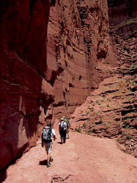
One of the best and most beautiful hiking trails on the Colorado Plateau and an experience not to be missed, the Fisher Towers Trail is spectacular in the winter or early spring when the red rocks contrast with the snow-covered La Sals Mountains, making for a very memorable hiking experience. While the snow and the red rocks will make an incredible picture, it may make the trail slippery or muddy, so is an easier winter hike if the trail is snow free. In the spring you will enjoy an array of beautiful desert flowers. Watch for the active lizards and ravens. A summer hike should begin very early in the morning to minimize the effects of the scorching heat.
Hiking Fisher Towers -
Photo by Yrma van der Steenstraeten |
|
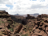
The rock formations along the trail are often used by experienced rock climbers. The Titan Tower, rising over 900 feet, was first climbed in May of 1962 by Huntley Ingals, Layton Kor, and George Hurley. The climb was cutting edge for the time and was featured in National Geographic magazine. Today, the Fisher Towers, and the Titan in particular, are home to some of the worlds most difficult and dangerous aid climbing routes. The towers are composed of the Organ Rock Tongue of the Cutler geologic formation capped by the Moenkopi formation.
View from Fisher Towers -
Photo by Yrma van der Steenstraeten |
 |
The access route to reach the Fisher Towers Trail follows the Colorado River Corridor, which is a Scenic Byway, so you can expect an incredibly beautiful drive along the river. The corridor accommodates a variety of recreational activities; river rafting, horseback riding, hiking, climbing, mountain biking, and camping are all very popular.
Besides beautiful scenery, this is an area rich in motion picture history. Countless commercials, some music videos, and many movies have been filmed using this landscape as a spectacular background. To tap into the rich film history of the area, it is worth a visit to the Moab Museum of Film and Western Heritage located conveniently in the Colorado River Corridor at the Red Cliffs Lodge at Mile Post 14 on Highway 128, better known as the River Road.
Set aside half a day to enjoy the area. Perhaps you will stop in for lunch or dinner at the Red Cliffs Ranch or the Sorrel River Ranch, which feature fine restaurants with great views.
Please follow the Hiking Safety Tips listed below. These simple recommendations will help you enjoy a safe trip wherever you choose to hike.
- Bring plenty of water (at least two quarts per person), especially in the summer.
- Wear a hat and use sunscreen.
- Follow the route markings. If you lose track of them, return to the last marker and look hard for the next one. Look for stacked piles of rocks called “cairns.”
- Take special care with cliff edges and exposure, and keep track of children. There are no guard rails.
To access the Fisher Towers Road and trail, take Utah State Highway 128, (the River Road), from its junction with Highway 191 at the Colorado River crossing stoplight. Coming from Moab, turn right at Milepost 21, and head up the dirt access road for 2.2 miles. There is a small five-site, but wonderful, primitive camp nestled among the pinyon and juniper trees near the trailhead and parking area, which includes a toilet, but no water.
Dave Erley is the Mayor of Castle Valley, and an active member of the Grand County Trail Mix Committee. Dave is a river runner, hiker, and mountain biker who works to make sure there is a place for the birds and the bees alongside recreational and other uses of our public lands.
Photos courtesy: Yrma van der Steenstraeten. |
 Trail Mix This committee represents non motorized trail users including: bikers, hikers, equestrians, and skiers. Many government agencies and private citizens comprise the “mix” that makes this group work so well. We meet the 2nd Tues. of each month from 12-2 at the Grand Center (500W. 182 N.). Everyone is welcome. Trail Mix This committee represents non motorized trail users including: bikers, hikers, equestrians, and skiers. Many government agencies and private citizens comprise the “mix” that makes this group work so well. We meet the 2nd Tues. of each month from 12-2 at the Grand Center (500W. 182 N.). Everyone is welcome.
Contact Sandy Freethey 259-0253 or find us online: wwwgrandcountyutah.net/trailmix/ or at moabtrailmixinfo@gmail.com.
|
|
"Staying Safe Doesn't Have to Mean Staying Home"
Manti-La Sal Avalanche Center |
When the weather in Moab gets cold, freezing the Colorado River and putting snow and ice on everybody’s favorite bike trail or climbing route, there is another alternative available. Find yourself in an inversion? It is time to go and discover the recreation opportunities in the La Sal Mountains. 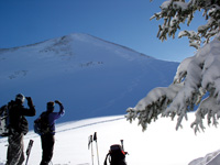
The La Sals are second only to the Uintas as the highest peaks in the state of Utah. These mountains soar to almost 13,000 feet above sea level and over 8,000 feet above the valley floor. A laccolith process formed the La Sals. With this process, a mass of igneous rock intruded between layers of sedimentary rock, resulting in uplift. You could call them frustrated volcanoes too. Aside from the volcanoes of the Pacific-Northwest, there are no peaks with greater rise in the continental U.S.
Winter recreation in the La Sals includes cross country skiing, skate skiing, snowshoeing, sledding, back-country skiing and snowmobiling. The winter access to the mountains is provided from two routes kept open by the Grand and San Juan County Road Departments.
1. The La Sal Mountain Loop Road is plowed regularly. The Geyser Pass road is kept open to the restrooms and parking area at 9,600’. The Geyser Pass Road and Gold Basin Road beyond the winter trailhead is a popular area for cross country skiing, snowshoeing and snowmobiling. Groomed trails are provided by the Lower Utah Nordic Alliance (LUNA). Volunteers groom trails approximately twice a week, which provide 12 kilometers of a groomed trail-system, open to every winter user group. These roads also provide access to backcountry skiing and snowboarding in the Mt. Tomasaki and Gold Basin areas. There is a sledding hill just below the parking lot. If you are using the sledding hill, please park in the parking lot so other vehicles can get to the parking lot. The road in the winter is narrow enough!
 Snowmobiles are not allowed to leave the road in Gold Basin. Please respect this closure of the most popular skiing area in the La Sals - the rest of the entire range is open to you! Snowmobiles are not allowed to leave the road in Gold Basin. Please respect this closure of the most popular skiing area in the La Sals - the rest of the entire range is open to you!
2. From near Old La Sal at the south end of the range, the road is plowed regularly two miles short of Dark Canyon Lake, just below Mount Peale. The San Juan Road Department makes a parking lot at about 9,600’.
Winter Huts are available for rent from…
Tag-A-Long Tours: 435-259-8946
These simple cabins are great for folks who want to spend several days in the mountains, but don’t want to lose a couple of hours driving back and forth from town every day. The hut operators can snow cat your supplies and camping gear in for you saving you the heavy carry.
Avalanche Hazard in the La Sal Mountains
The La Sals are rubbly piles of fractured stone. The angle of repose for this broken stone is 38 degrees, and since snow is also a granular substance, 38 degrees is the bulls-eye slope angle for snow avalanches. Keep in mind though, that avalanches run on terrain from 30 - 45 degrees. Most people caught in avalanches are in terrain that is 30 - 35 degrees of steepness. The La Sal Mountains usually possess one of the weakest snow packs imaginable.
For Current Advisories
259-SNOW (7669)
or on the Internet at
http://utahavalanchecenter.org/advisory/moab |
Why do we care? Because 30% of people completely buried by avalanches are killed by trauma and many of those remaining die from suffocation. These are not good odds. It’s not good policy to plan on outrunning an avalanche, even on a fast snowmobile, because avalanches have been clocked at well over 200 mph. Grim statistics showing that snowmobilers are the most likely people to be killed in avalanches also support this.
So what do we do? Fortunately, staying safe doesn’t have to mean staying at home! The good news is that most people trigger the slide that catches them, so if we learn a little about snow and adjust our behavior to suit the conditions, we can continue to enjoy our winter playground!
The Manti-La Sal Avalanche Center in Moab exists to help you make the right decisions. The MLSAC Forecasters examine the snow and produce an advisory informing you of where you are most likely to run into problems and just how sensitive the snow is. They also produce a mountain weather forecast, work with the Moab Winter Search and Rescue Team and provide avalanche education to the community in numerous ways. The MLSAC educates the community through the advisories, classes held periodically, radio announcements on the weekends on KZMU, the website and at the Geyser Pass Trailhead information board. The center director is Max Forgensi.
The website is a great tool for:
• Finding a weather forecast for the Moab area,
including radar images
• A current photo gallery of the La Sal Mountains
• Advisories for the La Sals and the Abajo Mountains
• A current course schedule for southeast Utah
UPCOMING AVALANCE CLASSES
Basic Avalanche Awareness Talk
Friday, January 6th, 2012 at 6:00 pm in the Grand County Library.
AIARE Level 1 Avalanche Course
Friday, February 3rd - Sunday February 5th.
Call to sign up 435-636-3335
You can also find class announcements online at
•http://utahavalanchecenter.org
•http://www.cnha.org/friends/
or by calling 259-SNOW (7669) |
Watch for periodic special events like ski swaps and avalanche awareness classes. If you need to talk to one of the avalanche forecasters, please call 259-7155 Monday-Friday during normal business hours and be sure to mention you read about it in Moab Happenings.
|
|
|
|
|
|
© 2002-2026 Moab Happenings. All rights
reserved.
Reproduction of information contained in this site is
expressly prohibited.
|
|