When the snow arrives in the La Sal Mountains, the white peaks present a dramatic backdrop to our red rock desert. This small mountain range beckons, and visitors and locals flock to ski and snowshoe in this private winter wonderland just a half hour or so from Moab.
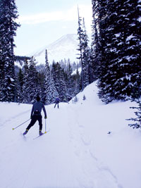 |
| Photo: Kirstin Peterson |
The Lower Utah Nordic Alliance (LUNA) works with the Manti-La Sal Forest Service to groom a Nordic track system starting from the Geyser Pass Trailhead. Beginning in mid-December or whenever the snowpack is established, dedicated LUNA volunteers drive snowmobiles pulling grooming equipment to lay a Nordic track wide enough for skate skiing plus parallel tracks on the side for classic skiers.
Starting at Geyser Pass Road winter trailhead at 9600 feet, the groomed track goes up from there, and sections are suitable for all levels of skiers and snowshoers. As you set out from the parking area, most of the track is “shared use,” and you will see a variety of winter recreationists including snowmobilers, backcountry skiers and snowboarders, snowshoe and sledding parties, often with canine companions. Please be courteous to other users, move right to allow others to safely pass, and stay under control when traveling downhill.
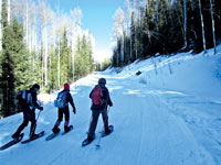 |
| Photo: Marc Thomas |
The Meadow Loop is the easiest and closest track to the parking lot. Ski a short way uphill from the trailhead, and you’ll see the Meadow Loop take off on the left and wind through aspens into a beautiful open meadow with Haystack Mountain in the background. The terrain is rolling, and the loop rejoins the main track close to where you entered. This .3-mile, sunny loop is fun to ski in either direction and is the perfect place to work on your form and get your lungs used to the high elevation.
Gold Basin is an intermediate track and is reached by continuing up the main Geyser Pass Road track from the Meadow Loop to the intersection with the Gold Basin Road, which branches right. The Gold Basin Track is rolling, though more uphill on the return, and offers a peaceful ski through pines and aspens with occasional views of the red rock desert below. You may see backcountry skiers accessing many of the popular runs above the track or returning from turns in the powder. The Gold Basin Track ends at the point where motorized travel is prohibited from going further, thus making this an out-and-back excursion totaling 8 km (5 miles) round trip from the trailhead.
For the ambitious and fit skier, Geyser Pass and the La Sal Loppet Loop, which branches off at the top of the pass, offer a challenging and beautiful Nordic skiing experience. The Lasaloppet [loppet is Swedish for long-distance cross-country ski event] was started by McKay Edwards of Moab Springs Ranch and marked the first true grooming of a big meadow loop off Geyser Pass. From the Gold Basin intersection, Geyser Pass is another 3.5 km (2 miles) mostly uphill. Geyser Pass tops out at 10,600 feet, and the La Sal Loppet Loop takes off to the right along the road towards Dark Canyon. After approximately .5 miles, the track leaves the main route on the left and winds through open meadows to a point offering views of Colorado, including the San Miguel and Wilson Mountains near Telluride. This rolling loop continues through the trees and emerges on the east side of the Geyser Pass Road, where you will take a left up a short hill back to the pass, adding an additional 1.8 miles (3 km) to your distance (13.2 km/8.6 miles total from trailhead). From the pass, it is mostly downhill back to the trailhead, so be sure to have a warmer, wind-protective layer for the descent. Whether you prefer skinny or fat skis, telemark or randonee [Alpine touring], classic or skating, snowboards or snowshoes or sleds, there’s something for you in Moab’s upper extremes.
Directions to trailhead: From Moab, head south on Highway 191 to the La Sal Mountain Loop Rd turn off at the south end of Spanish Valley. Turn left off the highway and then right onto the Loop Road for about 13 miles to a well marked turn onto Geyser Pass Road. From here, travel 3.5 miles to the trailhead. Note that snow tires and/or 4wd are recommended for this road. The road is plowed fairly regularly, but call 435-259-7155 or check http://utahavalanchecenter.org/advisory/moab for current conditions and the latest information about road clearing. Be prepared for winter conditions in the mountains, and bring appropriate warm clothing, water, and food for any outing into the backcountry. Other than toilet facilities, there are no services at the trailhead.
Kirstin Peterson is the ski representative for Trail Mix-
the Grand County non-motorized trails advisory committee when she’s not running her mountain bike tour company, Rim Tours. Trail Mix is a contributor to the ski-grooming program. If you are interested in volunteering to be one of the ski groomers, contact kirstin.m.p@gmail.com.
|
 Trail Mix This committee represents non motorized trail users including: bikers, hikers, equestrians, and skiers. Many government agencies and private citizens comprise the “mix” that makes this group work so well. We meet the 2nd Tues. of each month from 12-2 at the Grand Center (500W. 182 N.). Everyone is welcome.