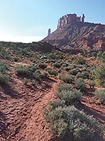
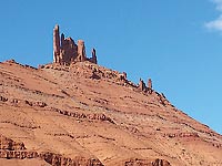
A great hike with some of the best views that the red rock country has to offer may be enjoyed along the Sylvester Trail. This is a photographer’s dream trail featuring the iconic Castleton Tower, the Priest and Nuns, Adobe Mesa and the La Sal mountains as a backdrop to a pleasant hike that may be lined with beautiful spring flowers. There are many unusual rock formations, and beckoning side canyons to explore, time permitting. Castleton Tower or Castle Rock is a favorite for climbers who access the rock tower via Castle Valley, so you may hear or see some climbers on your hike.
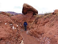
 The hike is intended as an out and back excursion. If you go to the top of the trail it will be 3 miles one way with approximately 800’ elevation gain. You begin with a gentle incline that increases as you go up the slope, becoming a moderate level hike as the trail narrows. The trail is not difficult, and becomes more scenic the higher you go. The good news is that when you choose to turn around, it is all downhill. Most of the trail is clearly identified, and occasionally you will find cairns, (small rock piles) to guide you. Bring food, sunscreen, a hat, binoculars and plenty of water on your hike. The hike is intended as an out and back excursion. If you go to the top of the trail it will be 3 miles one way with approximately 800’ elevation gain. You begin with a gentle incline that increases as you go up the slope, becoming a moderate level hike as the trail narrows. The trail is not difficult, and becomes more scenic the higher you go. The good news is that when you choose to turn around, it is all downhill. Most of the trail is clearly identified, and occasionally you will find cairns, (small rock piles) to guide you. Bring food, sunscreen, a hat, binoculars and plenty of water on your hike.
Typical vegetation in the area includes pinyon, juniper, and cottonwood trees, rabbit brush, black brush, cliff rose, prickly pear and claret cup cactus, and snake weed plants that all thrive in the Permian Cutler Geologic Formation, while the towering rocks are in the Windgate Formation.
The trail probably started as a cow trail and used by the local ranchers. It is occasionally used by equestrians. The Grand County Trail Mix Crew and the Bureau of Land Management teamed up to define and sign the trail, maneuvering around some rock obstacles to make the route a little easier for equestrians.
The Sylvester Trail is located off of Hwy 128, (the River Road). This beautiful stretch of road can be busy, so have patience and marvel at all the recreational activities along the Scenic Byway as you drive to the trailhead. Coming from Moab you will drive along side the amazing new paved bike path, which is an engineering feat and used by thousands of visitors and mountain bikers coming off of the Porcupine Rim Trail. As the road winds through the red rock canyon you may catch glimpses of kayakers and rafters enjoying the Colorado River, you will pass many happy campers lucky enough to get a spot next to the river.
 To access the trailhead turn right at mile post18.2 coming from Moab. A small sign reads, “Ranch Road Dead End”. A very faded hwy sign indicates that Onion Creek is two miles further up the road. The dirt road is suitable for all vehicles except after heavy rains. Continue on the dirt road until it ends in two miles. There is a kiosk at the trailhead that shows a map and gives a history of the area and talks about the name of the trail. To access the trailhead turn right at mile post18.2 coming from Moab. A small sign reads, “Ranch Road Dead End”. A very faded hwy sign indicates that Onion Creek is two miles further up the road. The dirt road is suitable for all vehicles except after heavy rains. Continue on the dirt road until it ends in two miles. There is a kiosk at the trailhead that shows a map and gives a history of the area and talks about the name of the trail.
Professor Valley and Professor Creek are named after Dr. Richardson, nicknamed, “the Professor”. Dr. Richardson led a colorful and eclectic life, holding many roles and titles; Doctor of medicine, teacher, geologist, postmaster, road builder, saw mill operator, shop owner, and county commissioner, to name a few. Sylvester, (from New York), and his wife, Mary Jane moved to Utah from Colorado and were among the early settlers in Professor Valley in the 1880’s. In 1898 the town named after Richardson was a uranium shipping point, now a ghost town. Enjoy the magnificent surroundings of canyons and cliffs, buttes and towers, and remember those who came before us.
 As an alternative to the out and back hike, the Sylvester Trail may be done as a one-way downhill route if you use two vehicles to do a shuttle starting at the top of the trail, which is accessed from Castle Valley/Castleton road. Driving on the Castleton Road for 5.2 miles you will turn left onto a dirt road before the paved road makes a sharp right and goes over a bridge. Take the left fork of the dirt road up the hill through a wire gate to reach the rim where you will park. Vehicles should have a bit of high clearance for this slightly more rugged road. Walk along the rim towards Castleton Tower, turn right as the trail goes downhill towards Professor Valley for a three mile hike. As an alternative to the out and back hike, the Sylvester Trail may be done as a one-way downhill route if you use two vehicles to do a shuttle starting at the top of the trail, which is accessed from Castle Valley/Castleton road. Driving on the Castleton Road for 5.2 miles you will turn left onto a dirt road before the paved road makes a sharp right and goes over a bridge. Take the left fork of the dirt road up the hill through a wire gate to reach the rim where you will park. Vehicles should have a bit of high clearance for this slightly more rugged road. Walk along the rim towards Castleton Tower, turn right as the trail goes downhill towards Professor Valley for a three mile hike.
Campgrounds in the area are found at Onion Creek and at Fisher Towers, as well as the many camps along the river.
 Trail Mix This committee represents non motorized trail users including: bikers, hikers, equestrians, and skiers. Many government agencies and private citizens comprise the “mix” that makes this group work so well. We meet the 2nd Tues. of each month from 12-2 at the Grand Center (500W. 182 N.). Everyone is welcome. Trail Mix This committee represents non motorized trail users including: bikers, hikers, equestrians, and skiers. Many government agencies and private citizens comprise the “mix” that makes this group work so well. We meet the 2nd Tues. of each month from 12-2 at the Grand Center (500W. 182 N.). Everyone is welcome.
Contact Sandy Freethey 259-0253 or find us online: wwwgrandcountyutah.net/trailmix/ or at moabtrailmixinfo@gmail.com.
|
|