|
|
Trail HAPPENINGS April 2016
|
New Trail Provides Access to Rarely-Visited Arch
by Marc Thomas |
Want to hike a relatively short trail that still provides panoramic views of petrified sand dunes, Behind the Rocks, and the LaSal Mountains, while throwing in rock art near its beginning and a graceful 60 foot arch at its end? Then go out and savor the 1.2 mile (each way) Longbow Arch Trail established in late 2015 by the BLM and Grand County Trail Mix..jpg)
Like the new Poison Spider Bench Trail described in February’s Moab Happenings, the freshly-minted trail to Longbow Arch is located off Potash Road (Hwy 279), starting at the Poison Spider 4x4 Trailhead just after the Williams Bottom Campground. At the east end of the parking area, there is a small trail map on the kiosk and the trail starts next to the pit toilet.
Beginning, you briefly follow the 200-yard trail to the Potash Road dinosaur tracks. At the signed trail junction, look for the painted green dots that point your way up the drainage you will be following. Before long you zigzag your way to the top of the first pour-off, with the spur to a hunting scene rock art panel (viewable from trail) just beyond.
Returning to the trail, you are soon climbing up a series of short, stony pour-offs until your way is seemingly blocked by a longer and steeper pour-off or “jump.” Here the trail builders have installed several ascending horseshoe-shaped steel bars that provide foot and hand holds to help you to climb the pour-off.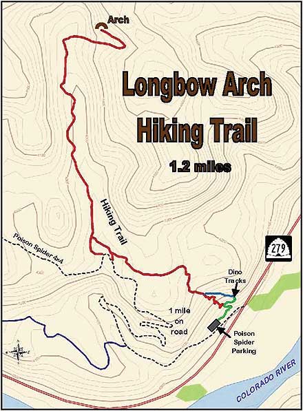
After the “jump”, the trail continues straight up the drainage. opening into a high desert landscape of juniper trees, blackbrush plants, and prickly pear cacti. While the bushes and cacti weren’t blooming when I hiked here in early March, they should be in flower for much of the spring.
Now a mixture of dirt, sand, and slickrock, the trail skirts a series of Navajo sandstone fins and domes that invite further play and exploration. Moving onward, you stroll into a scenic desert amphitheater rimmed by massive sandstone domes. Enclosed within these sandstone arms, the trail alternates between packed sand and slickrock before entering a small wash.
Following 200 yards of well-trodden sand, and the occasional paint stripe, the trail crosses a small sandstone fin and shortly turns right into the side canyon containing Longbow Arch, high up on its left wall. Snaking its way up both sides of the canyon drainage, in one place a short series of Moki steps helps you cross over a small stone wall. As you climb, the trail briefly passes by the arch, before a final upward turn to the left takes you right under the arch’s long and slender span.
Longbow Arch is close against the canyon wall, reminding one of Wall Arch in Arches National Park which famously collapsed back in 2008. This arch seems built to last, however, so it invites sitting or standing under it. As you face it, a stone platform at the left end of the arch makes a great spot to eat a snack and gaze upon the desert below or the sandstone fins surrounding you.
Return the way you came, although halfway back two “escape spurs” to the Poison Spider 4x4 Road can be accessed by anyone uneasy about backing down the horseshoe-shaped rebar at the dry waterfall “jump.”
 Trail Mix This committee represents non motorized trail users including: bikers, hikers, equestrians, and skiers. Many government agencies and private citizens comprise the “mix” that makes this group work so well. We meet the 2nd Tues. of each month from 12-2 at the Grand Center (500W. 182 N.). Everyone is welcome. Trail Mix This committee represents non motorized trail users including: bikers, hikers, equestrians, and skiers. Many government agencies and private citizens comprise the “mix” that makes this group work so well. We meet the 2nd Tues. of each month from 12-2 at the Grand Center (500W. 182 N.). Everyone is welcome.
Contact Sandy Freethey 259-0253 or find us online: wwwgrandcountyutah.net/trailmix/ or at moabtrailmixinfo@gmail.com.
|
|
Corona Arch
by Laurie Schmidt |
People come to Moab from all over the world to see the sandstone arches in Arches and Canyonlands National Parks. But believe it or not, one of the area’s most spectacular arches is not in a national park.
Located in a side canyon of the Colorado River called Bootlegger Canyon, Corona Arch stands more than 100 feet high with a 140-foot-wide opening. In official arch terminology it is known as a buttress arch, where one side is connected to the rock face and the other side projects out from the cliff, making it a partly freestanding arch. 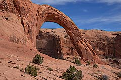
It’s not certain where the name Corona came from, but some folks suggest that the arch was so named because it looks like a solar flare arching off the sun (these flares are known as coronas). On some older maps, the arch is referenced as “Little Rainbow Bridge,” implying a smaller version of the famous Rainbow Bridge in Glen Canyon National Recreation Area, which is almost as tall as the Statue of Liberty.
The Trail
From the parking lot, you’ll start by climbing a short steep hill, but after that it’s not difficult hiking. At the top of the hill, you’ll cross the railroad tracks and go through a cattle guard. Soon the trail turns to the right, bringing you to a rocky section that takes you up through a gap in the rim. From here the trail alternates between sections of sandy path and rock cairns that lead you through a wash, over a sandy pass, and then down to the base of a cliff, where a safety cable leads you around a left turn.
Although the trail’s total elevation gain is only 440 feet, you will have to negotiate a steep 20-foot section of slickrock using another safety cable and steps carved into the rock. Immediately after that, a short ladder boosts you up to the top of the sandstone bench. None of these obstacles are difficult, but if you’re not feeling overly adventurous or energetic, you can still get a distant view of Corona Arch without climbing to the top. From the top of the ladder, it’s an easy walk along the bench to the base of Corona Arch.
As you make your way to the arch, there are many overhangs that provide shade for a nice rest or lunch stop. You’ll also pass beneath Bowtie Arch, a sandstone pothole arch with a diameter of about 30 feet. Pothole arches form when water collects in pothole depressions, eventually cutting through to the layer below via chemical weathering. Below Bowtie Arch is a series of hanging seeps, where mosses and greenery grow in sharp contrast to the surrounding redrock.
“Arch Enemy #1”
As you stand beneath the behemoth Corona Arch, try to imagine someone flying a plane through it. That’s exactly what Tim Martin used to do. Now in his 70s, Martin grew up in Moab. At the age of 36 he decided to take flying lessons, and he was such a natural that his flight instructor let him take his first solo flight after about four hours of training. But simply flying over the Canyonlands area wasn’t enough—Martin took recreational flying to another level.
The same year he got his pilot’s license, he flew his fixed-wing plane through the arch opening of the massive Rainbow Bridge. According to Martin, one day he just looked at the arch and thought to himself…I could probably fly through that. And he did. But Martin decided that Rainbow Bridge didn’t offer much of a challenge, due to its large opening. So he moved on to other smaller arches, including Corona Arch.
Martin estimates that since the early 1980s, he’s piloted his plane through Corona Arch about 300 times. But his arch flying days are pretty much behind him now, which he says his wife is very thankful for. If you want to get up in the air with him, though, he still works for a local aviation company in Moab, taking visitors on scenic flights over the Arches, Canyonlands, and Monument Valley areas.
Hiking Distance (round-trip): 3 miles
Difficulty: Moderate
Fees: No fee
Cautions: High temperatures during summer; some ladder climbing required
Getting There
From Moab, Utah: Drive north from Moab on Hwy 191 for about 4 miles and turn left onto Hwy 279 (Potash Road). Continue for about 10 miles to the signed turnoff for the Corona Arch trailhead. The trail is on the right as you pull into the gravel parking lot.
Laurie Schmidt is the author of Utah Canyon Country: 20 Must-See Sites and Short Adventures. This article is excerpted from the book. Visit her Canyon Country Blog at www.utahcanyonhikes.com
|
|
|
|
|
|
© 2002-2024 Moab Happenings. All rights
reserved.
Reproduction of information contained in this site is
expressly prohibited.
|
|