In May hobbits, elves, dwarves, rangers (with a small “r”), ents and other nature lovers can pursue their quests in the realms of Moab’s Middle Earth. Our Middle Earth comprises the mesas and canyons tucked between the increasingly dry and desiccating desert and the snowy forests of the high La Sal. Here you will find mystic towers, red-walled castles, impenetrable ramparts, and intricate mazes of forest and boulder replete with such exotic flower and form that no imagination can remain unenchanted. To reach the inner sanctums of the Land of Beyond an intrepid pedestrian must seek the lonely glens and glades that are unreachable by loud, smelly orc-a-types. Fortunately, there are many pristine pockets of serenity in Middle Earth where the dizzying wizardry of the wheel hardly penetrates.
FISHER MESA
Fisher Mesa is a simple place to walk for carefree miles and offers phenomenal vistas in all directions. While the mesa does invite wheeled visitors, it isn’t very busy and there is plenty of room for one and all. It requires about an hour of driving through epic scenery to reach the trailhead. Take the River Road (Hwy 128) to the Castle Valley turnoff. Proceed up Castle Valley and follow the signs toward Gateway; don’t turn on to the Loop Road. This paved road climbs and climbs. At the top you come to a large parking area just before the road goes to gravel. The trailhead starts here, passing through a pedestrian gate in a wire fence. Sometimes this is as far as I get. Bring a picnic and relax. The air is cool. The view is breathtaking. The ecosystem is rare and exceptional. And, as a bonus, about fifty yards past the fence and slightly to the left, there are some of the biggest dinosaur tracks in the Moab area. Further adventures are guaranteed if you drive a little further and take the turn to Beaver Mesa.
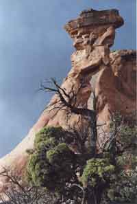
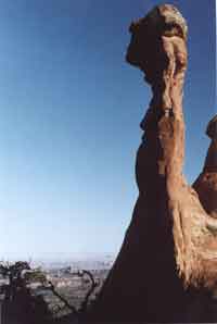
THE LOST WORLD
A great treasure can be in front of your face, unnoticed but for some fortuitous circumstance. The Lost World is one such place. Often observed, but seldom visited, the Lost World is an isolated province of intricately eroded Entrada sandstone perched in splendid isolation inside Mill Creek Canyon. It’s so close…too obvious. People always stop, but seldom enter. I can’t remember seeing a fresh footprint there that didn’t belong to me or a companion. Take the La Sal Loop Road past the Pack Creek turn off and ascend the first set of switchbacks. There is a parking area at the top of these switchbacks. The canyon below is your goal. Go down the ridge to your left and seek a way into the mystic citadel beneath your feet…fairy towered and corridored with a lovely slot canyon. The far rim looms above Mill Creek and is rich with panoramic viewpoints. Although there is access down to the creek, the route is obscure. Any such attempt is best left to the experienced on a later visit.
THE BURKHOLDER- RILL DIVIDE
There is a Divide between Burkholder Creek and Rill Creek, two fingers of Mill Creek’s Left Hand. Drive up Sand Flats Road past the Porcupine Rim Trailhead. The road gets steep and rough, but is negotiable by patient two-wheel driving. Rill Creek Canyon is on your right. That promontory is the point of the divide. Some maps call this Tombstone Ridge, but I hate those nasty old cowboy names, especially when they imply something wicked, grim, or morbid of a place that is innately sacred, uplifting, and enlivening. My friend, Joel, whimsically named this area “Bubbleland” for the strange froth of boulders on top. Although I prefer this to “Tombstone”, I’m afraid it will never catch on.
Two miles past the Porcupine Rim trailhead is a turnout near the top of Rill Creek Canyon. This is a good place to begin. Work your way around the head of the canyon and past the point of the ridge. It’s a straightforward hike but there is no trail. About two miles out, after you turn the point, there is a saddle on the left that takes you into the head of Burkholder Canyon. This is an excellent place to seek a personal definition of the word “magic”.
The easiest way to get to the top of the Divide is to drive one mile east, or up hill. The ridge on your right has a large bowl in it. Go up there then bear right. This can be a challenging walk but is still the easiest way to get your ticket punched for an amusing visit to Bubbleland. Wear long pants in any case. Note well where you access the top as this area can divert you to confusion. Other descents are possible but problematical and usually include a steep, brushy torture-thrash through thick oak scrub and a high probability of a ruefully memorable experience.
Rory Tyler leads custom rock art tours and backcountry hikes for people of all skill levels for Canyon Voyages Adventure Company.
|
Cryptos (krip’ tose): The surface of Moab’s desert is held together by a thin skin of living organisms known as cryptobiotic soil or cryptos. It has a lumpy black appearance, is very fragile, and takes decades to heal when it has been damaged. This soil is a critical part of the survival of the desert. The cryptobiotic organisms help to stabilize the soil, hold moisture, and provide protection for germination of the seeds of other plants.
Without it the dry areas of the west would be much different. Although some disturbance is normal and helps the soil to capture moisture, excessive disturbance by hooves, bicycle tires and hiking boots has been shown to destroy the cryptobiotic organisms and their contribution to the soil. When you walk around Moab avoid crushing the cryptos. Stay on trails, walk in washes, hop from stone to stone.
Whatever it takes, don’t crunch the cryptos unless you absolutely have to! |
|